Login
Register


DLL
Baraboo/Wisconsin Dells Regional Airport
Official FAA Data Effective 2026-02-19 0901Z
Chart Supplement

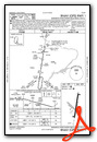
VFR Chart of KDLL
Sectional Charts at SkyVector.com
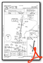
IFR Chart of KDLL
Enroute Charts at SkyVector.com
Location Information for KDLL
Coordinates: N43°31.32' / W89°46.27'Located 03 miles NW of Baraboo, Wisconsin on 312 acres of land. View all Airports in Wisconsin.
Surveyed Elevation is 980 feet MSL.
Operations Data
|
|
Airport Communications
| AWOS-3: | 118.325 Tel. 608-356-1071 |
|---|---|
| MADISON APPROACH: | 135.45 343.7 |
| MADISON DEPARTURE: | 135.45 343.7 |
| UNICOM: | 123.050 |
| CTAF: | 123.050 |
| AWOS-3PT at C35 (9.1 W): | 118.95 608-768-0023 |
| AWOS-3 at 82C (24.8 NW): | 123.925 608-562-6153 |
| ASOS at LNR (25.8 SW): | 119.425 608-583-2576 |
- APCH/DEP SVC PRVDD BY CHICAGO ARTCC ON FREQS 133.3/257.925 (LONE ROCK RCAG) WHEN MADISON APCH CTL CLSD.
Nearby Navigation Aids
|
| ||||||||||||||||||||||||||||||||||||||||||||||||||||||||||||


Runway 01/19
| Dimensions: | 5010 x 100 feet / 1527 x 30 meters | |
|---|---|---|
| Surface: | Asphalt in Excellent Condition | |
| Weight Limits: | S-30, D-55 | |
| Edge Lighting: | Medium Intensity | |
| Runway 01 | Runway 19 | |
| Coordinates: | N43°30.94' / W89°46.30' | N43°31.75' / W89°46.13' |
| Elevation: | 977.0 | 967.5 |
| Traffic Pattern: | Left | Left |
| Runway Heading: | 9° True | 189° True |
| Markings: | Non-Precision Instrument in good condition. | Non-Precision Instrument in good condition. |
| Glide Slope Indicator | P2L (3.00° Glide Path Angle) PAPI UNUSBL BYD 8 DEGS LEFT OF CNTRLN. | P2L (3.00° Glide Path Angle) |
| REIL: | Yes | Yes |
| Obstacles: | 50 ft Trees 1555 ft from runway, 290 ft left of center | |
Runway 14/32
| Dimensions: | 2725 x 100 feet / 831 x 30 meters | |
|---|---|---|
| Surface: | Turf in Good Condition | |
| Runway 14 | Runway 32 | |
| Coordinates: | N43°31.44' / W89°46.60' | N43°31.13' / W89°46.16' |
| Elevation: | 971.9 | 977.2 |
| Traffic Pattern: | Left | Left |
| Runway Heading: | 134° True | 314° True |
| Markings: | None | None |
| Obstacles: | 85 ft Tree 1325 ft from runway, 90 ft right of center | |
Services Available
| Fuel: | 100LL (blue), Jet A+ |
|---|---|
| Transient Storage: | Hangars,Tiedowns |
| Airframe Repair: | MAJOR |
| Engine Repair: | MAJOR |
| Bottled Oxygen: | NONE |
| Bulk Oxygen: | NONE |
| Other Services: | PILOT INSTRUCTION,AIRCRAFT RENTAL |
Ownership Information
| Ownership: | Publicly owned | |
|---|---|---|
| Owner: | VILLAGE OF LAKE DELTON | |
| PO BOX 50 | ||
| LAKE DELTON, WI 53940 | ||
| 608-254-2558 | ||
| Manager: | TIM MCCUMBER | |
| PO BOX 50 | ||
| LAKE DELTON, WI 53940 | ||
| 608-254-2558 | EXTENSION 227 | |
Other Remarks
- BIRDS ON & INVOF ARPT IN FALL.
- FOR CD CTC MADISON APP/DEP CON AT 608-249-8240. WHEN MADISON APCH CLSD, FOR CD CTC CHICAGO ARTCC AT 630-906-8921.
- RWY 14/32 NOT PLWD & CLSD NOV 15 THRU APR 15; CFM STS CTC - 608-356-2270.
- NOISE ABATEMENT: AVOID OVERFLIGHT OF WILDLIFE SANCTUARY 1.5 NM NE.
- MKD WITH YELLOW/BLACK A-FRAMES AND YELLOW CONES.
- MKD WITH YELLOW/BLACK A-FRAMES AND YELLOW CONES.
- 0LL 24 HR FUEL AVBL WITH CREDIT CARD.
- MIRL RWY 01/19 PRESET TO LOW SS-SR; TO INCR INTST & ACTVT REIL RWY 01 & 19; PAPI RWY 01 & 19 - CTAF.
Weather Minimums


Instrument Approach Procedure (IAP) Charts


Nearby Airports with Instrument Procedures
| ID | Name | Heading / Distance | ||
|---|---|---|---|---|
 |
C35 | Reedsburg Municipal Airport | 271° | 9.3 |
|
C47 | Portage Municipal Airport | 079° | 12.8 |
|
91C | Sauk/Prairie Airport | 177° | 13.5 |
|
82C | Mauston/New Lisbon Union Airport | 320° | 24.8 |
|
KLNR | Tri-County Regional Airport | 224° | 25.8 |
|
63C | Adams County Legion Field Airport | 358° | 26.3 |
|
C29 | Middleton Municipal/Morey Field Airport | 156° | 26.6 |
|
93C | Richland Airport | 238° | 27.1 |
|
KMSN | Dane County Regional/Truax Field Airport | 140° | 29.8 |
|
KVOK | Volk Field Airport | 320° | 32.7 |
|
KDAF | Necedah Airport | 336° | 33.6 |
|
87Y | Blackhawk Airfield Airport | 134° | 35.9 |
Airport Images
Do you have a recent image of this airport? Upload it here!


