Login
Register


C35
Reedsburg Municipal Airport
Official FAA Data Effective 2026-01-22 0901Z
Chart Supplement

VFR Chart of C35
Sectional Charts at SkyVector.com
IFR Chart of C35
Enroute Charts at SkyVector.com
Location Information for C35
Coordinates: N43°31.55' / W89°58.99'Located 01 miles E of Reedsburg, Wisconsin on 153 acres of land. View all Airports in Wisconsin.
Surveyed Elevation is 906 feet MSL.
Operations Data
|
|
Airport Communications
| AWOS-3PT: | 118.95 Tel. 608-768-0023 |
|---|---|
| MADISON APPROACH: | 135.45 343.7 |
| MADISON DEPARTURE: | 135.45 343.7 |
| UNICOM: | 122.800 |
| CTAF: | 122.800 |
| AWOS-3 at DLL (9.1 E): | 118.325 608-356-1071 |
| AWOS-3 at 82C (19.9 N): | 123.925 608-562-6153 |
| ASOS at LNR (20.7 SW): | 119.425 608-583-2576 |
- APCH/DEP SVC PRVDD BY CHICAGO ARTCC ON FREQS 133.3/257.925 (LONE ROCK RCAG) WHEN MADISON APCH CTL CLSD.
Nearby Navigation Aids
|
| ||||||||||||||||||||||||||||||||||||||||||||||||||||||


Runway 18/36
| Dimensions: | 4840 x 75 feet / 1475 x 23 meters | |
|---|---|---|
| Surface: | Asphalt in Fair Condition | |
| Weight Limits: | S-30 | |
| Edge Lighting: | Medium Intensity | |
| Runway 18 | Runway 36 | |
| Coordinates: | N43°31.91' / W89°58.93' | N43°31.11' / W89°58.94' |
| Elevation: | 904.9 | 881.4 |
| Traffic Pattern: | Left | Left |
| Runway Heading: | 181° True | 1° True |
| Displaced Threshold: | 440 Feet | 300 Feet |
| Declared Distances: | TORA:4540 TODA:4540 ASDA:4540 LDA:4100 | TORA:4400 TODA:4400 ASDA:4400 LDA:4100 |
| Markings: | Non-Precision Instrument in good condition. | Non-Precision Instrument in good condition. |
| Glide Slope Indicator | P2L (3.00° Glide Path Angle) | |
| REIL: | Yes | Yes |
| Obstacles: | 21 ft Road 230 ft from runway APCH SLP 20:1 TO DTHR. 10 FT FENCE 190 FT FM RWY END, 120 FT R. |
17 ft Railroad 200 ft from runway, 180 ft left of center APCH SLP 20:1 TO DTHR. 17 FT RR 75 FT FM RWY END 250 FT L. |
Runway 07/25
| Dimensions: | 2510 x 50 feet / 765 x 15 meters | |
|---|---|---|
| Surface: | Asphalt in Good Condition | |
| Weight Limits: | S-30 | |
| Edge Lighting: | Medium Intensity | |
| Runway 07 | Runway 25 | |
| Coordinates: | N43°31.57' / W89°59.37' | N43°31.72' / W89°58.84' |
| Elevation: | 891.5 | 906.2 |
| Traffic Pattern: | Left | Left |
| Runway Heading: | 69° True | 249° True |
| Displaced Threshold: | 229 Feet | 300 Feet |
| Declared Distances: | TORA:2210 TODA:2210 ASDA:2210 LDA:1980 | TORA:2280 TODA:2280 ASDA:2280 LDA:1980 |
| Markings: | Basic in good condition. | Basic in good condition. |
| Obstacles: | 49 ft Trees 945 ft from runway, 225 ft left of center APCH RATIO 20:1 TO DSPLCD THR. DITCH 10 FT FM RWY END 60 FT L. |
12 ft Road 200 ft from runway APCH RATIO 20:1 TO DSPLCD THR. 10 FT FENCE 175 FT FM RWY END, 40 FT L. |
Services Available
| Fuel: | 100LL (blue), Jet A+ |
|---|---|
| Transient Storage: | Hangars,Tiedowns |
| Airframe Repair: | MAJOR |
| Engine Repair: | MAJOR |
| Bottled Oxygen: | NONE |
| Bulk Oxygen: | NONE |
| Other Services: | PILOT INSTRUCTION,AIRCRAFT RENTAL |
Ownership Information
| Ownership: | Publicly owned | |
|---|---|---|
| Owner: | CITY OF REEDSBURG | |
| ARPT COMSN 200 VINE STREET | ||
| REEDSBURG, WI 53959 | ||
| 608-524-2396 | ||
| Manager: | TOM PARKER | |
| 1720 E MAIN | EMAIL ADDRESS: REEDSBURGAVIATION@GMAIL.COM (ALL LOWER CASE) | |
| REEDSBURG, WI 53959 | ||
| 608-524-2322 | ||
Other Remarks
- FOR CD CTC MADISON APP/DEP CON AT 608-249-8240. WHEN MADISON APCH CLSD, FOR CD CTC CHICAGO ARTCC AT 630-906-8921.
- 0LL 24 HR FUEL AVBL WITH CREDIT CARD.
- MIRL RWY 18/36 & 07/25 PRESET TO LOW SS-SR; TO INCR INTST AND ACTVT REIL RWY 18 & 36; PAPI RWY 18 - CTAF.
Weather Minimums


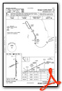
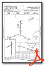
Instrument Approach Procedure (IAP) Charts
Nearby Airports with Instrument Procedures
| ID | Name | Heading / Distance | ||
|---|---|---|---|---|
 |
KDLL | Baraboo/Wisconsin Dells Regional Airport | 091° | 9.3 |
|
91C | Sauk/Prairie Airport | 143° | 16.9 |
|
82C | Mauston/New Lisbon Union Airport | 340° | 19.9 |
|
93C | Richland Airport | 223° | 20.0 |
|
KLNR | Tri-County Regional Airport | 204° | 20.7 |
|
C47 | Portage Municipal Airport | 084° | 21.9 |
|
63C | Adams County Legion Field Airport | 017° | 27.4 |
|
KVOK | Volk Field Airport | 334° | 27.4 |
|
KDAF | Necedah Airport | 351° | 30.8 |
|
C29 | Middleton Municipal/Morey Field Airport | 141° | 31.6 |
|
Y72 | Bloyer Field Airport | 321° | 34.6 |
|
KMSN | Dane County Regional/Truax Field Airport | 129° | 36.5 |
Airport Images

By: AirMarshall


