Login
Register


ABR
Aberdeen Regional Airport
Official FAA Data Effective 2026-02-19 0901Z
Chart Supplement

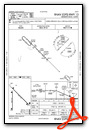
KABR Airport Diagram

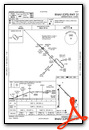
VFR Chart of KABR
Sectional Charts at SkyVector.com
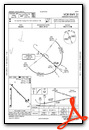
IFR Chart of KABR
Enroute Charts at SkyVector.com
Location Information for KABR
Coordinates: N45°26.81' / W98°25.35'Located 02 miles E of Aberdeen, South Dakota on 1284 acres of land. View all Airports in South Dakota.
Surveyed Elevation is 1301 feet MSL.
Operations Data
|
|
Airport Communications
| ASOS: | 125.875 Tel. 605-206-9423 |
|---|---|
| CTAF: | 122.700 |
| UNICOM: | 122.700 |
| AWOS-3P at 1D8 (35.8 S): | 118.525 605-475-1877 |
| AWOS-3P at BTN (36.1 NE): | 118.275 605-448-2110 |
| AWOS-3 at 2D5 (45.9 N): | 118.675 701-742-3991 |
- APCH/DEP SVC PRVDD BY MINNEAPOLIS ARTCC ON FREQS 120.6/371.9 (ABERDEEN RCAG).
Nearby Navigation Aids
|
| ||||||||||||||||||||||||||||||


Runway 13/31
| Dimensions: | 6901 x 100 feet / 2103 x 30 meters | |
|---|---|---|
| Surface: | Concrete / Grooved in Good Condition | |
| Weight Limits: | S-120, D-195, ST-339
PCR VALUE: 476/R/D/W/T
| |
| Edge Lighting: | High Intensity | |
| Runway 13 | Runway 31 | |
| Coordinates: | N45°27.31' / W98°25.68' | N45°26.51' / W98°24.54' |
| Elevation: | 1301.9 | 1300.9 |
| Traffic Pattern: | Left | Left |
| Runway Heading: | 135° True | 315° True |
| Declared Distances: | TORA:6901 TODA:6901 ASDA:6901 LDA:6901 | TORA:6901 TODA:6901 ASDA:6901 LDA:6901 |
| Markings: | Precision Instrument in good condition. | Precision Instrument in good condition. |
| Glide Slope Indicator | P4L (3.00° Glide Path Angle) | P4L (3.00° Glide Path Angle) |
| Approach Lights: | MALSR 1,400 Foot Medium-intensity Approach Lighting System with runway alignment indicator lights. | |
| REIL: | Yes | |
Runway 17/35
| Dimensions: | 5500 x 100 feet / 1676 x 30 meters | |
|---|---|---|
| Surface: | Asphalt / Grooved in Excellent Condition | |
| Weight Limits: | S-63, D-82, ST-139
PCR VALUE: 250/F/D/X/T
| |
| Edge Lighting: | Medium Intensity | |
| Runway 17 | Runway 35 | |
| Coordinates: | N45°27.13' / W98°25.64' | N45°26.22' / W98°25.64' |
| Elevation: | 1301.8 | 1300.3 |
| Traffic Pattern: | Left | Left |
| Runway Heading: | 180° True | 360° True |
| Declared Distances: | TORA:5500 TODA:5500 ASDA:5500 LDA:5500 | TORA:5500 TODA:5500 ASDA:5500 LDA:5500 |
| Markings: | Precision Instrument in good condition. | Precision Instrument in good condition. |
| Glide Slope Indicator | P4R (3.00° Glide Path Angle) | P4L (3.00° Glide Path Angle) |
| REIL: | Yes | Yes |
Services Available
| Fuel: | 100LL (blue), Jet-A |
|---|---|
| Transient Storage: | Hangars |
| Airframe Repair: | MAJOR |
| Engine Repair: | MAJOR |
| Bottled Oxygen: | NOT AVAILABLE |
| Bulk Oxygen: | HIGH |
| Other Services: | AIR FREIGHT SERVICES,CROP DUSTING SERVICES,AIR AMBULANCE SERVICES,CHARTER SERVICE,PILOT INSTRUCTION,AIRCRAFT RENTAL,AIRCRAFT SALES |
Ownership Information
| Ownership: | Publicly owned | |
|---|---|---|
| Owner: | CITY OF ABERDEEN | |
| 123 S LINCOLN ST | ||
| ABERDEEN, SD 57401-1420 | ||
| 605-626-7020 | ||
| Manager: | RICH KROKEL | |
| 4740 6TH AVENUE SE | ||
| ABERDEEN, SD 57401-4215 | ||
| 605-626-7020 | ||
Other Remarks
- BIRDS ON & INVOF ARPT.
- ARPT NOT AVBL FOR INTL ARRIVALS.
- SURFACE CONDITIONS NOT MONITORED 0000-0330L
- FOR CD IF UNA TO CTC ON FSS FREQ, CTC MINNEAPOLIS ARTCC AT 651-463-5588.
- ACTVT MALSR RWY 31; REIL RWYS 13, 17, & 35; & PAPI RWY 13/31,17/35 - CTAF; MIRL RWY 17/35 & HIRL RWY 13/31 PRESET ON LOW INTST SS-2400; TO INCR INTST USE CTAF.
Weather Minimums


Instrument Approach Procedure (IAP) Charts


Nearby Airports with Instrument Procedures
| ID | Name | Heading / Distance | ||
|---|---|---|---|---|
 |
4E7 | Ellendale Municipal Airport | 353° | 34.4 |
|
KBTN | Britton Municipal Airport | 052° | 36.2 |
|
8D7 | Clark County Airport | 137° | 44.8 |
|
2D5 | Oakes Municipal Airport | 018° | 45.9 |
|
51D | Edgeley Municipal Airport | 346° | 55.7 |
|
KGWR | Gwinner/Roger Melroe Field Airport | 034° | 56.7 |
|
KMKA | Miller Municipal Airport | 202° | 59.8 |
|
8D3 | Sisseton Municipal Airport | 076° | 61.7 |
|
KATY | Watertown Regional Airport | 120° | 62.6 |
|
KHON | Huron Regional Airport | 172° | 64.2 |
|
6L3 | Lisbon Municipal Airport | 025° | 66.7 |
|
9D0 | Highmore Municipal Airport | 219° | 69.8 |
Fuel Providers

Airport Images
Do you have a recent image of this airport? Upload it here!


