Login
Register


BTN
Britton Municipal Airport
Official FAA Data Effective 2026-02-19 0901Z
Chart Supplement

VFR Chart of KBTN
Sectional Charts at SkyVector.com
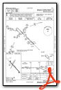
IFR Chart of KBTN
Enroute Charts at SkyVector.com
Location Information for KBTN
Coordinates: N45°48.90' / W97°44.57'Located 02 miles N of Britton, South Dakota on 192 acres of land. View all Airports in South Dakota.
Surveyed Elevation is 1318 feet MSL.
Operations Data
|
|
Airport Communications
| AWOS-3P: | 118.275 Tel. 605-448-2110 |
|---|---|
| UNICOM: | 122.800 |
| CTAF: | 122.800 |
| AWOS-3 at GWR (24.6 N): | 118.325 701-678-6801 |
| AWOS-3 at 2D5 (25.7 NW): | 118.675 701-742-3991 |
| ASOS at ABR (35.9 SW): | 125.875 605-206-9423 |
- APCH/DEP SVC PRVDD BY MINNEAPOLIS ARTCC ON FREQS 120.6/371.9 (ABERDEEN RCAG).
Nearby Navigation Aids
|
| ||||||||||||||||||||||||||||||||||||||||||||||||


Runway 13/31
| Dimensions: | 4210 x 75 feet / 1283 x 23 meters | |
|---|---|---|
| Surface: | Asphalt in Good Condition | |
| Weight Limits: | S-12 | |
| Edge Lighting: | Medium Intensity | |
| Runway 13 | Runway 31 | |
| Coordinates: | N45°49.10' / W97°44.87' | N45°48.61' / W97°44.17' |
| Elevation: | 1314.6 | 1318.4 |
| Traffic Pattern: | Left | Left |
| Runway Heading: | 135° True | 315° True |
| Markings: | Non-Precision Instrument in good condition. | Non-Precision Instrument in good condition. |
| Glide Slope Indicator | P2L (3.00° Glide Path Angle) | P2L (3.20° Glide Path Angle) |
| REIL: | Yes | Yes |
| Obstacles: | 15 ft Road 800 ft from runway | 88 ft Trees 1990 ft from runway |
Runway 01/19
| Dimensions: | 2034 x 120 feet / 620 x 37 meters | |
|---|---|---|
| Surface: | Turf in Good Condition | |
| Runway 01 | Runway 19 | |
| Coordinates: | N45°48.84' / W97°44.77' | N45°49.15' / W97°44.58' |
| Elevation: | 1312.4 | 1312.6 |
| Traffic Pattern: | Left | Left |
| Runway Heading: | 23° True | 203° True |
| Markings: | Non-Standard | Non-Standard |
| Obstacles: | 6 ft Fence 125 ft from runway HAS +6' FENCE POST 98' FM CNTRLN OF RY. |
18 ft Road 390 ft from runway |
Services Available
| Fuel: | 100LL (blue), Jet-A |
|---|---|
| Transient Storage: | Hangars,Tiedowns |
| Airframe Repair: | MINOR |
| Engine Repair: | MINOR |
| Bottled Oxygen: | NONE |
| Bulk Oxygen: | NONE |
| Other Services: | CROP DUSTING SERVICES |
Ownership Information
| Ownership: | Publicly owned | |
|---|---|---|
| Owner: | CITY OF BRITTON | |
| 803 8TH ST | ||
| BRITTON, SD 57430 | ||
| 605-448-5721 | ||
| Manager: | RYAN FURMAN | |
| PO BOX 941 | ||
| BRITTON, SD 57430 | ||
| (605) 470-0485 | ||
Other Remarks
- RY 19 +6 FT FENCE 190 FT FM THLD.
- WATERFOWL AND GULLS ON & INVOF ARPT.
- GCO AVBL ON FREQ 121.725 (4 CLICKS TO MINNEAPOLIS CENTER AND 6 CLICKS TO FLT SVCS)
- WILDLIFE ON AND AROUND AIRPORT
- FOR CD IF UNA VIA GCO CTC MINNEAPOLIS ARTCC AT 651-463-5588.
- NSTD MKGS: RY 01/19 MARKED WITH BLACK AND WHITE CONES.
- 0LL FUEL AVBL 24 HRS WITH CREDIT CARD
- ACTVT MIRL, REIL & PAPI RYS 13 & 31 - CTAF.
- AUTOMATED UNICOM.
Weather Minimums


Instrument Approach Procedure (IAP) Charts

Nearby Airports with Instrument Procedures
| ID | Name | Heading / Distance | ||
|---|---|---|---|---|
 |
KGWR | Gwinner/Roger Melroe Field Airport | 009° | 24.6 |
|
2D5 | Oakes Municipal Airport | 326° | 25.7 |
|
8D3 | Sisseton Municipal Airport | 105° | 32.7 |
|
4E7 | Ellendale Municipal Airport | 290° | 34.6 |
|
KABR | Aberdeen Regional Airport | 232° | 36.2 |
|
6L3 | Lisbon Municipal Airport | 000° | 37.9 |
|
KETH | Wheaton Municipal Airport | 091° | 50.4 |
|
51D | Edgeley Municipal Airport | 308° | 52.4 |
|
KBWP | Harry Stern Airport | 061° | 54.0 |
|
8D7 | Clark County Airport | 178° | 55.2 |
|
K74 | Robert Odegaard Field Airport | 031° | 58.9 |
|
KATY | Watertown Regional Airport | 155° | 59.5 |
Airport Images
Do you have a recent image of this airport? Upload it here!


