Login
Register


MKA
Miller Municipal Airport
Official FAA Data Effective 2025-11-27 0901Z
Chart Supplement

VFR Chart of KMKA
Sectional Charts at SkyVector.com
IFR Chart of KMKA
Enroute Charts at SkyVector.com
Location Information for KMKA
Coordinates: N44°31.51' / W98°57.48'Located 02 miles E of Miller, South Dakota on 252 acres of land. View all Airports in South Dakota.
Surveyed Elevation is 1569 feet MSL.
Operations Data
|
|
Airport Communications
| CTAF: | 122.900 |
|---|---|
| AWOS-3P at 1D8 (27.0 NE): | 118.525 605-475-1877 |
| ASOS at HON (32.4 E): | 118.125 605-215-0039 |
| AWOS-3P at 9V9 (48.2 S): | 118.025 605-234-1437 |
- APCH/DEP SVC PRVDD BY MINNEAPOLIS ARTCC ON FREQS 125.1/269.1 (PIERRE RCAG).
Nearby Navigation Aids
|
| ||||||||||||||||||||||||||||||||||||||||||||||||


Runway 15/33
| Dimensions: | 3601 x 60 feet / 1098 x 18 meters | |
|---|---|---|
| Surface: | Concrete in Excellent Condition | |
| Weight Limits: | S-125 | |
| Edge Lighting: | Medium Intensity | |
| Runway 15 | Runway 33 | |
| Coordinates: | N44°31.79' / W98°57.64' | N44°31.24' / W98°57.33' |
| Elevation: | 1560.8 | 1569.6 |
| Runway Heading: | 158° True | 338° True |
| Markings: | Non-Precision Instrument in good condition. | Non-Precision Instrument in good condition. |
| Glide Slope Indicator | P2L (3.00° Glide Path Angle) | P2L (3.00° Glide Path Angle) |
| Obstacles: | 35 ft Pole 1370 ft from runway, 80 ft right of center | |
Services Available
| Fuel: | 100LL (blue) |
|---|---|
| Transient Storage: | Hangars,Tiedowns |
| Airframe Repair: | MINOR |
| Engine Repair: | MINOR |
| Bottled Oxygen: | NONE |
| Bulk Oxygen: | NONE |
| Other Services: | CROP DUSTING SERVICES |
Ownership Information
| Ownership: | Publicly owned | |
|---|---|---|
| Owner: | CITY OF MILLER | |
| 120 W 2ND ST | ||
| MILLER, SD 57362 | ||
| 605-853-2705 | ||
| Manager: | TERRY MANNING | |
| 120 W 2ND ST | ||
| MILLER, SD 57362 | ||
| 605-853-2705 | ||
Other Remarks
- GCO AVBL ON FREQ 121.725 (4 CLICKS TO MINNEAPOLIS CENTER AND 6 CLICKS TO FLT SVCS)
- FOR CD IF UNA VIA GCO CTC MINNEAPOLIS ARTCC AT 651-463-5588.
- 0LL FOR FUEL CALL 605-204-0565, 605-204-0730.
- ACTVT PAPI RWYS 15 & 33; MIRL RWY 15/33 - 122.8.
Weather Minimums

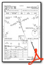
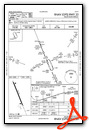
Instrument Approach Procedure (IAP) Charts
Nearby Airports with Instrument Procedures
| ID | Name | Heading / Distance | ||
|---|---|---|---|---|
 |
9D0 | Highmore Municipal Airport | 272° | 21.2 |
|
1D8 | Redfield Municipal Airport | 042° | 27.0 |
|
KHON | Huron Regional Airport | 104° | 32.5 |
|
4X4 | Wessington Springs Airport | 146° | 33.3 |
|
9V9 | Chamberlain Municipal Airport | 199° | 48.2 |
|
98D | Onida Municipal Airport | 282° | 50.1 |
|
0D8 | Gettysburg Municipal Airport | 303° | 50.7 |
|
KPIR | Pierre Regional Airport | 261° | 57.7 |
|
8D7 | Clark County Airport | 066° | 57.8 |
|
KABR | Aberdeen Regional Airport | 022° | 59.8 |
|
KMHE | Mitchell Municipal Airport | 138° | 60.0 |
|
6E5 | Wilder Airport | 094° | 60.4 |
Airport Images

By: jcbecker@pie.mi...


