Login
Register


ACZ
Wallace-Pender Airport
Official FAA Data Effective 2026-02-19 0901Z
Chart Supplement

VFR Chart of KACZ
Sectional Charts at SkyVector.com
IFR Chart of KACZ
Enroute Charts at SkyVector.com
Location Information for KACZ
Coordinates: N34°43.07' / W78°0.23'Located 01 miles SW of Wallace, North Carolina on 145 acres of land. View all Airports in North Carolina.
Surveyed Elevation is 38 feet MSL.
Operations Data
|
|
Airport Communications
| AWOS-3P: | 121.07 Tel. 910-285-0419 |
|---|---|
| WILMINGTON APPROACH: | 135.75 317.425 ;344-163 |
| WILMINGTON DEPARTURE: | 135.75 317.425 ;344-163 |
| UNICOM: | 122.800 |
| CTAF: | 122.800 |
| AWOS-3 at DPL (16.9 N): | 120.675 910-296-9688 |
| AWOS-3PT at OAJ (20.0 E): | 910-324-5233 |
| ATIS at OAJ (20.4 E): | 124.475 |
- APCH/DEP SVC PRVDD BY WASHINGTON ARTCC ON FREQS 124.025/269.15 (WILMINGTON RCAG) WHEN WILMINGTON APCH CTL CLSD.
Nearby Navigation Aids
|
| ||||||||||||||||||||||||||||||||||||||||||||||||||||||||||||


Runway 09/27
| Dimensions: | 4153 x 75 feet / 1266 x 23 meters | |
|---|---|---|
| Surface: | Asphalt in Good Condition | |
| Weight Limits: | S-12 | |
| Edge Lighting: | Medium Intensity | |
| Runway 09 | Runway 27 | |
| Coordinates: | N34°43.04' / W78°0.65' | N34°43.10' / W77°59.82' |
| Elevation: | 37.9 | 29.2 |
| Traffic Pattern: | Left | Left |
| Runway Heading: | 85° True | 265° True |
| Displaced Threshold: | 149 Feet | 151 Feet |
| Markings: | Non-Precision Instrument in good condition. | Non-Precision Instrument in good condition. |
| Glide Slope Indicator | P2L (3.13° Glide Path Angle) | P2L (3.53° Glide Path Angle) |
Services Available
| Fuel: | 100LL (blue), Jet A-1+ |
|---|---|
| Transient Storage: | Tiedowns |
| Airframe Repair: | MAJOR |
| Engine Repair: | MAJOR |
| Bottled Oxygen: | NONE |
| Bulk Oxygen: | NONE |
| Other Services: | PILOT INSTRUCTION,AIRCRAFT RENTAL |
Ownership Information
| Ownership: | Publicly owned | |
|---|---|---|
| Owner: | TOWN OF WALLACE | |
| 316 E. MURRAY STREET, PO BOX 849 | ||
| WALLACE, NC 28466 | ||
| 910-285-4136 | ||
| Manager: | BEN JONES | |
| 250 HENDERSON FIELD ROAD | ||
| WALLACE, NC 28466 | ||
| 910-285-6642 | FBO (DAY): 910-285-6642. AFT HRS: 910-271-8955. ALTN (POLICE DEPT): 910-285-2126. | |
Other Remarks
- 5 FT DITCH 135 FT RIGHT OF CNTRLN RWY 09.
- 7 FT DITCH 140 FT LEFT OF CNTRLN RWY 27.
- RWY 27 SAFETY AREA HAS 20 FT DEPRESSIONS/CREEK 160 FT FR THR BOTH SIDES CNTRLN.
- MIL ACFT LIMIT DLA ON RWY TO AVOID DAMAGE TO RWY SURFACES.
- NOISE ABATEMENT PROCS IN EFF, CALL AMGR 910-271-8955.
- WALLACE-PENDER ARPT CLSD TO TOUCH & GO/PRACTICE APCHS 2100-0600 LCL DLY.
- ARPT CLSD TO MIL ACFT EXCEPT 1 HR PPR.
- FOR CD CTC WILMINGTON APCH AT 910-815-4676, OR WHEN APCH CLSD CTC WASHINGTON ARTCC AT 703-771-3587.
- 0LL 24 HR SELF SVC FUEL WITH CREDIT CARD.
- ACTVT MIRLS RWY 09/27- CTAF. PAPIS OPR CONSLY.
Weather Minimums

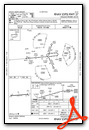
Instrument Approach Procedure (IAP) Charts

Nearby Airports with Instrument Procedures
| ID | Name | Heading / Distance | ||
|---|---|---|---|---|
 |
KDPL | Duplin County Airport | 003° | 16.9 |
|
KOAJ | Albert J Ellis Airport | 070° | 20.5 |
|
KCTZ | Clinton-Sampson County Airport | 310° | 23.6 |
|
KILM | Wilmington International Airport | 169° | 27.2 |
|
KNCA | New River MCAS (Mccutcheon Field) Airport | 090° | 27.9 |
|
KEYF | Curtis L Brown Jr Field Airport | 256° | 29.3 |
|
W40 | Mount Olive Municipal Airport | 356° | 30.2 |
|
KGSB | Seymour Johnson AFB Airport | 003° | 37.3 |
|
KISO | Kinston Regional Jetport At Stallings Field Airport | 027° | 41.6 |
|
KCPC | Columbus County Regional Airport | 233° | 44.2 |
|
KGWW | Wayne Exec Jetport Airport | 002° | 44.5 |
|
KFAY | Fayetteville Regional/Grannis Field Airport | 290° | 46.3 |
Airport Images
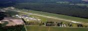
By: marenyi@gmail.com


