Login
Register


GWW
Wayne Exec Jetport Airport
Official FAA Data Effective 2025-12-25 0901Z
Chart Supplement

VFR Chart of KGWW
Sectional Charts at SkyVector.com
IFR Chart of KGWW
Enroute Charts at SkyVector.com
Location Information for KGWW
Coordinates: N35°27.63' / W77°57.90'Located 03 miles N of Goldsboro, North Carolina on 249 acres of land. View all Airports in North Carolina.
Surveyed Elevation is 133 feet MSL.
Operations Data
|
|
Airport Communications
| AWOS-3P: | 118.975 Tel. 919-731-4473 |
|---|---|
| SEYMOUR JOHNSON APPROACH: | 121.175 290.9 |
| SEYMOUR JOHNSON DEPARTURE: | 121.175 290.9 |
| CTAF: | 122.975 |
| UNICOM: | 122.975 |
| ATIS at GSB (7.3 S): | 317.625 |
| AWOS-3PT at GSB (7.6 S): | 317.625 |
| AWOS-3P at W40 (14.8 S): | 120.075 919-658-8067 |
- APCH/DEP SVC PRVDD BY WASHINGTON ARTCC (ZDC) ON 123.85/279.65 (NEW BERN RCAG) WHEN APCH CTL CLSD.
Nearby Navigation Aids
|
| ||||||||||||||||||||||||||||||||||||||||||||||||||||||||||||


Runway 05/23
| Dimensions: | 5501 x 100 feet / 1677 x 30 meters | |
|---|---|---|
| Surface: | Asphalt in Excellent Condition | |
| Weight Limits: | 19 /F/C/X/T, S-51, D-71 | |
| Edge Lighting: | Medium Intensity | |
| Runway 05 | Runway 23 | |
| Coordinates: | N35°27.28' / W77°58.24' | N35°27.99' / W77°57.55' |
| Elevation: | 132.7 | 132.7 |
| Traffic Pattern: | Left | Left |
| Runway Heading: | 39° True | 219° True |
| Markings: | Non-Precision Instrument in good condition. | Precision Instrument in good condition. |
| Glide Slope Indicator | P4L (3.00° Glide Path Angle) | P4L (3.00° Glide Path Angle) |
| Approach Lights: | ODALS Omnidirectional Approach Lighting System | |
| REIL: | Yes | Yes |
| Obstacles: | 93 ft Trees 2163 ft from runway, 393 ft right of center HAS 9 FT BRUSH 135 FT FM THR OFFSET 327 LEFT OF CNTRLN. |
52 ft Trees 782 ft from runway, 581 ft right of center |
Services Available
| Fuel: | 100LL (blue), Jet A-1+ |
|---|---|
| Transient Storage: | Hangars,Tiedowns |
| Airframe Repair: | MAJOR |
| Engine Repair: | MAJOR |
| Bottled Oxygen: | NONE |
| Bulk Oxygen: | NONE |
| Other Services: | CROP DUSTING SERVICES,PILOT INSTRUCTION,AIRCRAFT RENTAL,AIRCRAFT SALES |
Ownership Information
| Ownership: | Publicly owned | |
|---|---|---|
| Owner: | WAYNE COUNTY | |
| 240 AVIATION ROAD | ||
| PIKEVILLE, NC 27863 | ||
| 919-734-7630 | ||
| Manager: | GENE DAWSON | |
| 240 AVIATION ROAD | ||
| PIKEVILLE, NC 27863 | ||
| 919-734-7630 | ||
Other Remarks
- ULTRALIGHT; GLIDER & PARACHUTE ACTIVITY PPR CALL 919-734-7630.
- HELICOPTER OPS ON TWY LEADING TO T HANGERS. HELIPAD ON TWY WITH TRAFFIC CONES AND FLAGS.
- BIRD ACTIVITY INVOF ARPT.
- FOR EMERG SVC AFT HRS CALL 919-734-7630.
- FOR CD CTC SEYMOUR JOHNSON APCH AT 919-722-4186. WHEN APCH CLSD, FOR CD CTC WASHINGTON ARTCC AT 703-771-3587.
- 0LL 24 HR SS FUEL AVAILABLE W CC.
- ACTVT REIL RWY 05 & 23; ODALS RWY 23; MIRL RWY 05/23 - CTAF. PAPIS RWY 05 & 23 OPERS CONS.
Weather Minimums
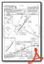
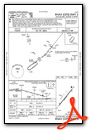
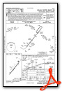
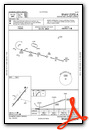
Instrument Approach Procedure (IAP) Charts
Nearby Airports with Instrument Procedures
| ID | Name | Heading / Distance | ||
|---|---|---|---|---|
 |
KGSB | Seymour Johnson AFB Airport | 178° | 7.3 |
|
W40 | Mount Olive Municipal Airport | 194° | 14.8 |
|
W03 | Wilson Industrial Air Center Airport | 359° | 18.6 |
|
KISO | Kinston Regional Jetport At Stallings Field Airport | 113° | 19.1 |
|
KJNX | Johnston Regional Airport | 283° | 21.4 |
|
KRWI | Rocky Mount/Wilson Regional Airport | 008° | 24.0 |
|
KDPL | Duplin County Airport | 181° | 27.6 |
|
KPGV | Pitt-Greenville Airport | 069° | 30.3 |
|
KETC | Tarboro-Edgecombe Airport | 035° | 35.1 |
|
KCTZ | Clinton-Sampson County Airport | 214° | 35.1 |
|
KHRJ | Harnett Regional Jetport Airport | 262° | 37.9 |
|
KLHZ | Triangle North Exec Airport | 332° | 38.1 |
Airport Images
Do you have a recent image of this airport? Upload it here!


