Login
Register


ADM
Ardmore Municipal Airport
Official FAA Data Effective 2026-02-19 0901Z
Chart Supplement

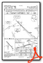
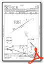
KADM Airport Diagram

VFR Chart of KADM
Sectional Charts at SkyVector.com
IFR Chart of KADM
Enroute Charts at SkyVector.com
Location Information for KADM
Coordinates: N34°18.23' / W97°1.24'Located 10 miles NE of Ardmore, Oklahoma on 2177 acres of land. View all Airports in Oklahoma.
Surveyed Elevation is 776 feet MSL.
Operations Data
|
|
Airport Communications
| ATIS: | 125.6 |
|---|---|
| AWOS-3: | 125.6 Tel. 580-389-5078 |
| ARDMORE TOWER: | 118.5 257.7 |
| ARDMORE GROUND: | 121.8 |
| UNICOM: | 122.950 |
| CTAF: | 118.500 |
| EMERG: | 121.5 243.0 |
| AWOS-3 at 1F0 (10.5 SW): | 118.15 580-226-1536 |
| AWOS-3 at PVJ (26.3 N): | 118.675 405-238-4452 |
| AWOS-3PT at ADH (34.7 NE): | 118.725 580-332-6222 |
- APCH/DEP CTL SVC PRVDD BY FORT WORTH ARTCC (ZFW) ON FREQS 124.75/323.0 (ARDMORE RCAG).
Nearby Navigation Aids
|
| ||||||||||||||||||||||||||||||||||||||||||||||||


Runway 13/31
| Dimensions: | 9002 x 150 feet / 2744 x 46 meters | |
|---|---|---|
| Surface: | Concrete in Good Condition | |
| Edge Lighting: | High Intensity | |
| Runway 13 | Runway 31 | |
| Coordinates: | N34°18.88' / W97°1.76' | N34°17.83' / W97°0.50' |
| Elevation: | 776.7 | 728.9 |
| Traffic Pattern: | Left | Left |
| Runway Heading: | 135° True | 315° True |
| Markings: | Precision Instrument in fair condition. | Precision Instrument in fair condition. |
| Glide Slope Indicator | P4L (3.00° Glide Path Angle) | V4L (3.00° Glide Path Angle) |
| Approach Lights: | MALSR 1,400 Foot Medium-intensity Approach Lighting System with runway alignment indicator lights. | |
| Obstacles: | 72 ft Trees 2000 ft from runway, 660 ft left of center | 68 ft Trees 2075 ft from runway, 366 ft left of center |
Runway 17/35
| Dimensions: | 5404 x 100 feet / 1647 x 30 meters | |
|---|---|---|
| Surface: | Asphalt in Good Condition | |
| Weight Limits: | S-36 | |
| Edge Lighting: | Medium Intensity | |
| Runway 17 | Runway 35 | |
| Coordinates: | N34°18.47' / W97°1.41' | N34°17.58' / W97°1.42' |
| Elevation: | 751.1 | 724.7 |
| Traffic Pattern: | Left | Left |
| Runway Heading: | 180° True | 0 |
| Displaced Threshold: | 397 Feet | |
| Declared Distances: | TORA:5007 TODA:5007 ASDA:5007 LDA:5007 | TORA:5404 TODA:5404 ASDA:5404 LDA:5007 |
| Markings: | Basic in good condition. | Basic in good condition. |
Services Available
| Fuel: | 100LL (blue), Jet-A |
|---|---|
| Transient Storage: | Hangars,Tiedowns |
| Airframe Repair: | MAJOR |
| Engine Repair: | MAJOR |
| Bottled Oxygen: | HIGH |
| Bulk Oxygen: | NONE |
| Other Services: | PILOT INSTRUCTION,AIRCRAFT RENTAL |
Ownership Information
| Ownership: | Publicly owned | |
|---|---|---|
| Owner: | CITY OF ARDMORE | ARPT OPERD BY ARDMORE DVLPMT AUTH 580-389-5238. |
| 23 S. WASHINGTON | ||
| ARDMORE, OK 73401 | ||
| 580-226-2100 | ||
| Manager: | DAN LUTTRELL | |
| 620 GENERAL DR., SUITE 1 | ||
| ARDMORE, OK 73401 | ||
| 580-389-5238 | ||
Other Remarks
- FOR CD IF UNA TO CTC ON FSS FREQ, CTC FORT WORTH ARTCC AT 817-858-7584.
- WHEN ATCT CLSD ACTVT MALSR RWY 31; HIRL RWY 13/31 - CTAF; MIRL RWY 17/35 ON DUSK-DAWN.
Weather Minimums

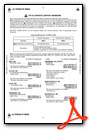
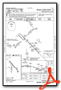
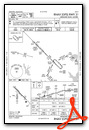
Instrument Approach Procedure (IAP) Charts
Nearby Airports with Instrument Procedures
| ID | Name | Heading / Distance | ||
|---|---|---|---|---|
 |
1F0 | Ardmore Downtown Exec Airport | 208° | 10.7 |
|
1F4 | Madill Municipal Airport | 133° | 14.3 |
|
KPVJ | Pauls Valley Municipal Airport | 337° | 26.3 |
|
KADH | Ada Regional Airport | 029° | 34.6 |
|
KDUA | Durant Regional/Eaker Field Airport | 124° | 38.0 |
|
KGYI | North Texas Regional/Perrin Field Airport | 153° | 39.3 |
|
KGLE | Gainesville Municipal Airport | 192° | 40.0 |
|
KSWI | Sherman Municipal Airport | 151° | 46.1 |
|
KDUC | Halliburton Field Airport | 282° | 47.7 |
|
F99 | Holdenville Municipal Airport | 032° | 55.6 |
|
1K4 | David Jay Perry Airport | 336° | 55.6 |
|
0F2 | Bowie Municipal Airport | 222° | 56.5 |


Comments
There is a Museum in the Line Shack
Museum inside of the line shack. No fuel and no NOTAM for no fuel but they pumped the bottom of the tank truck to get me some fuel. Probably won't stop here again since 1F0 is now open.
Pages