Login
Register


1F4
Madill Municipal Airport
Official FAA Data Effective 2026-01-22 0901Z
Chart Supplement

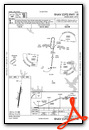
VFR Chart of 1F4
Sectional Charts at SkyVector.com
IFR Chart of 1F4
Enroute Charts at SkyVector.com
Location Information for 1F4
Coordinates: N34°8.42' / W96°48.72'Located 03 miles NW of Madill, Oklahoma on 59 acres of land. View all Airports in Oklahoma.
Surveyed Elevation is 890 feet MSL.
Operations Data
|
|
Airport Communications
| CTAF: | 122.900 |
|---|---|
| AWOS-3 at ADM (13.7 NW): | 125.6 580-389-5078 |
| ATIS at ADM (14.3 NW): | 125.6 |
| AWOS-3 at 1F0 (15.5 W): | 118.15 580-226-1536 |
- APCH/DEP CTL SVC PRVDD BY FORT WORTH ARTCC (ZFW) ON FREQS 124.75/323.0 (ARDMORE RCAG).
Nearby Navigation Aids
|
| ||||||||||||||||||||||||||||||||||||||||||||||||||||||


Runway 18/36
| Dimensions: | 3005 x 60 feet / 916 x 18 meters | |
|---|---|---|
| Surface: | Asphalt in Good Condition | |
| Weight Limits: | S-8 | |
| Edge Lighting: | Medium Intensity | |
| Runway 18 | Runway 36 | |
| Coordinates: | N34°8.67' / W96°48.69' | N34°8.18' / W96°48.76' |
| Elevation: | 862.0 | 881.0 |
| Traffic Pattern: | Left | Left |
| Runway Heading: | 186° True | 6° True |
| Markings: | Non-Precision Instrument in good condition. | Non-Precision Instrument in good condition. |
| REIL: | Yes | Yes |
Services Available
| Fuel: | NONE |
|---|---|
| Transient Storage: | Tiedowns |
| Airframe Repair: | MAJOR |
| Engine Repair: | MAJOR |
| Bottled Oxygen: | NONE |
| Bulk Oxygen: | NONE |
| Other Services: | PILOT INSTRUCTION |
Ownership Information
| Ownership: | Publicly owned | |
|---|---|---|
| Owner: | CITY OF MADILL | |
| CITY HALL, 201 E. OVERTON | ||
| MADILL, OK 73446 | ||
| 580-795-5586 | ||
| Manager: | DAVID MCDANIEL | |
| CITY HALL, 201 E. OVERTON | ||
| MADILL, OK 73446 | ||
| 580-795-4017 | ||
Other Remarks
- THIS AIRPORT HAS BEEN SURVEYED BY THE NATIONAL GEODETIC SURVEY.
- +1694 FT TWR 6.2 MI SOUTH OF RY 36 END.
- FOR CD CTC FORT WORTH ARTCC AT 817-858-7584.
- MIRL RY 18/36 PRESET MED INTENSITY DUSK-0000. AFTER 0000 ACTVT - CTAF.
Weather Minimums

Instrument Approach Procedure (IAP) Charts
Nearby Airports with Instrument Procedures
| ID | Name | Heading / Distance | ||
|---|---|---|---|---|
 |
KADM | Ardmore Municipal Airport | 313° | 14.3 |
|
1F0 | Ardmore Downtown Exec Airport | 271° | 15.5 |
|
KDUA | Durant Regional/Eaker Field Airport | 119° | 24.0 |
|
KGYI | North Texas Regional/Perrin Field Airport | 164° | 26.4 |
|
KSWI | Sherman Municipal Airport | 159° | 32.9 |
|
KGLE | Gainesville Municipal Airport | 213° | 35.0 |
|
KPVJ | Pauls Valley Municipal Airport | 329° | 39.7 |
|
KADH | Ada Regional Airport | 009° | 40.4 |
|
F00 | Jones Field Airport | 134° | 44.7 |
|
80F | Antlers Municipal Airport | 086° | 57.9 |
|
0F2 | Bowie Municipal Airport | 236° | 57.9 |
|
KTKI | Mckinney Ntl Airport | 168° | 58.8 |
Airport Images
Do you have a recent image of this airport? Upload it here!


