Login
Register
0F2
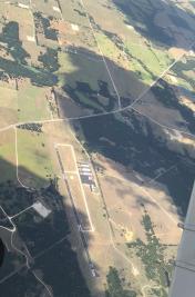
Bowie Municipal Airport
Official FAA Data Effective 2026-01-22 0901Z
VFR Chart of 0F2
Sectional Charts at SkyVector.com
IFR Chart of 0F2
Enroute Charts at SkyVector.com
Location Information for 0F2
Coordinates: N33°36.10' / W97°46.53'Located 04 miles NE of Bowie, Texas on 52 acres of land. View all Airports in Texas.
Surveyed Elevation is 1100 feet MSL.
Operations Data
|
|
Airport Communications
| AWOS-3PT: | 118.75 Tel. 940-872-2366 |
|---|---|
| CTAF: | 122.800 |
| UNICOM: | 122.800 |
| AWOS-3 at LUD (23.0 SE): | 118.225 940-627-2365 |
| AWOS-3PT at XBP (25.9 S): | 119.225 940-683-8027 |
| AWOS-3 at GLE (29.0 E): | 118.375 940-612-3549 |
- APCH/DEP SVC PRVDD BY FORT WORTH ARTCC (ZFW) ON FREQS 127.95/322.325 (WICHITA FALLS RCAG).
Nearby Navigation Aids
|
| ||||||||||||||||||||||||||||||||||||||||||||||||||||||||||||
Runway 17/35
| Dimensions: | 3603 x 60 feet / 1098 x 18 meters | |
|---|---|---|
| Surface: | Asphalt in Good Condition | |
| Weight Limits: | S-12 | |
| Edge Lighting: | Medium Intensity | |
| Runway 17 | Runway 35 | |
| Coordinates: | N33°36.40' / W97°46.57' | N33°35.80' / W97°46.50' |
| Elevation: | 1100.5 | 1082.6 |
| Traffic Pattern: | Left | Left |
| Runway Heading: | 174° True | 354° True |
| Markings: | Non-Precision Instrument in good condition. | Non-Precision Instrument in good condition. |
| Glide Slope Indicator | P2L (3.00° Glide Path Angle) | P2L (3.00° Glide Path Angle) |
| Obstacles: | 26 ft Pole 620 ft from runway, 208 ft right of center 4 FT FENCE, 0-199 FT DSTC, 246 FT. RIGHT. |
5 ft Trees 200 ft from runway, 210 ft left of center 8 FT TREES 0-200 FM THR 228 FT L. |
Services Available
| Fuel: | 100LL (blue), Jet-A |
|---|---|
| Transient Storage: | Hangars,Tiedowns |
| Airframe Repair: | NOT AVAILABLE |
| Engine Repair: | NOT AVAILABLE |
| Bottled Oxygen: | NONE |
| Bulk Oxygen: | NONE |
| Other Services: | CROP DUSTING SERVICES EXTENSIVE AGRI OPS JAN-APR. |
Ownership Information
| Ownership: | Publicly owned | |
|---|---|---|
| Owner: | CITY OF BOWIE | |
| 303 N MASON | ||
| BOWIE, TX 76230 | ||
| 940-872-1114 | ||
| Manager: | STONY LOWRANCE | PUBLIC WORKS DIR./AMGR. |
| 303 N MASON | ||
| BOWIE, TX 76230 | ||
| 940-841-4156 | ||
Other Remarks
- RWY 17/35 PVMT LIP 1.5 INCHES ABV GRADE.
- DEER ON & INVOF ARPT.
- RWY 35 30 FT DROP-OFF 190 FT DSTC, BOTH SIDES.
- CROP DUSTING JAN-APRIL.
- FOR CD CTC FORT WORTH ARTCC AT 817-858-7584.
- 0LL 100LL & JET A 24 HR SELF-SERVE.
- DUSK-DAWN. ACTVT PAPI RWY 17 & 35; MIRL RWY 17/35 - CTAF.
Weather Minimums
Instrument Approach Procedure (IAP) Charts
Nearby Airports with Instrument Procedures
| ID | Name | Heading / Distance | ||
|---|---|---|---|---|
 |
KLUD | Decatur Municipal Airport | 154° | 23.0 |
 |
KXBP | Bridgeport Municipal Airport | 185° | 25.8 |
 |
KGLE | Gainesville Municipal Airport | 083° | 29.1 |
 |
KDTO | Denton Enterprise Airport | 129° | 37.6 |
 |
KCWC | Kickapoo Downtown Airport | 293° | 39.0 |
 |
4T2 | Kenneth Copeland Airport | 159° | 40.0 |
 |
KSPS | Sheppard AFB/Wichita Falls Municipal Airport | 303° | 42.7 |
 |
KAFW | Perot Field/Fort Worth Alliance Airport | 147° | 43.2 |
 |
1F0 | Ardmore Downtown Exec Airport | 044° | 46.2 |
 |
KRPH | Graham Municipal Airport | 233° | 49.0 |
 |
KMWL | Mineral Wells Regional Airport | 196° | 51.2 |
 |
KFTW | Fort Worth Meacham International Airport | 155° | 51.2 |


