Login
Register


AFP
Anson County/Jeff Cloud Field Airport
Official FAA Data Effective 2026-02-19 0901Z
Chart Supplement

VFR Chart of KAFP
Sectional Charts at SkyVector.com
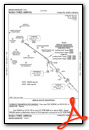
IFR Chart of KAFP
Enroute Charts at SkyVector.com
Location Information for KAFP
Coordinates: N35°1.24' / W80°4.63'Located 03 miles N of Wadesboro, North Carolina on 433 acres of land. View all Airports in North Carolina.
Surveyed Elevation is 299 feet MSL.
Operations Data
|
|
Airport Communications
| AWOS-3: | 119.325 Tel. 704-695-0623 |
|---|---|
| CHARLOTTE APPROACH: | 120.05 307.8 |
| CHARLOTTE DEPARTURE: | 120.05 307.8 |
| CTAF: | 122.800 |
| JOOLS STAR: | 135.6 377.15 |
| RASLN STAR: | 126.15 282.325 |
| UNICOM: | 122.800 |
| AWOS-3 at RCZ (17.4 SE): | 118.775 910-997-4093 |
| AWOS-3 at CQW (19.3 S): | 124.825 843-537-3301 |
| AWOS-3 at VUJ (24.1 N): | 128.175 704-986-2097 |
Nearby Navigation Aids
|
| ||||||||||||||||||||||||||||||||||||||||||||||||||||||||||||


Runway 16/34
| Dimensions: | 5498 x 100 feet / 1676 x 30 meters | |
|---|---|---|
| Surface: | Asphalt in Excellent Condition | |
| Weight Limits: | S-12, D-60 | |
| Edge Lighting: | Medium Intensity | |
| Runway 16 | Runway 34 | |
| Coordinates: | N35°1.65' / W80°4.86' | N35°0.83' / W80°4.39' |
| Elevation: | 299.3 | 296.8 |
| Traffic Pattern: | Left | Left |
| Runway Heading: | 155° True | 335° True |
| Markings: | Non-Precision Instrument in good condition. | Precision Instrument in good condition. |
| Glide Slope Indicator | P4L (3.00° Glide Path Angle) | P4L (3.00° Glide Path Angle) |
| REIL: | Yes | Yes |
| Obstacles: | 83 ft Trees 1426 ft from runway, 221 ft right of center 14 FT TREES 139 FT FROM END OF RWY AND OFFSET 308 FT RIGHT OF CNTRLN. |
23 ft Trees 579 ft from runway, 356 ft right of center 17 FT HILL 0-200 FT FROM END OF RWY AND 364 FT LEFT OF CNTRLN. |
Services Available
| Fuel: | 100LL (blue), Jet A-1+ |
|---|---|
| Transient Storage: | Tiedowns |
| Airframe Repair: | NONE |
| Engine Repair: | NONE |
| Bottled Oxygen: | NONE |
| Bulk Oxygen: | NONE |
Ownership Information
| Ownership: | Publicly owned | |
|---|---|---|
| Owner: | ANSON COUNTY | |
| 101 S. GREENE STREET | ||
| WADESBORO, NC 28170 | ||
| 704-994-3200 | ||
| Manager: | REX EDWARDS | |
| 2980 AIRPORT ROAD | ||
| WADESBORO, NC 28170 | ||
| (704) 389-0633 | ||
Other Remarks
- DEER IN VICINITY OF ARPT.
- FOR CD CTC CHARLOTTE APCH AT 704-359-0241.
- RWY 34 HAS 60+ FT UNMARKED POWER LINES 2700 FT FM THR BOTH SIDES OF CNTRLN.
- 0LL 100LL FUEL - 24 HR SELF SVC AVBL WITH CREDIT CARD.
- + FOR JET-A AFT HRS CALL FBO DURG OFC HRS FOR PRE-ARNGMT.
- ACTVT REILS RWY 16 & 34; PAPI RWY 16 & 34; MIRL RWY 16/34 - CTAF.
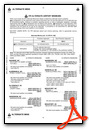
Weather Minimums

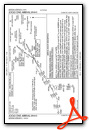
Standard Terminal Arrival (STAR) Charts
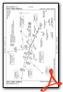

Instrument Approach Procedure (IAP) Charts


Nearby Airports with Instrument Procedures
| ID | Name | Heading / Distance | ||
|---|---|---|---|---|
 |
KRCZ | Richmond County Airport | 116° | 17.5 |
|
KCQW | Cheraw Municipal/Lynch Bellinger Field Airport | 162° | 19.4 |
|
KPYG | Pageland Airport | 218° | 21.3 |
|
KVUJ | Stanly County Airport | 351° | 24.0 |
|
43A | Montgomery County Airport | 032° | 26.0 |
|
KEQY | Charlotte/Monroe Exec Airport | 269° | 26.9 |
|
KBBP | Marlboro County Jetport/H E Avent Field Airport | 144° | 29.3 |
|
N52 | Jaars-Townsend Airport | 254° | 34.4 |
|
KUDG | Darlington County Airport | 164° | 35.6 |
|
KSOP | Moore County Airport | 068° | 36.3 |
|
KHVS | Hartsville Regional Airport | 183° | 37.1 |
|
KMEB | Laurinburg/Maxton Airport | 111° | 37.7 |
Airport Images
Do you have a recent image of this airport? Upload it here!


