Login
Register


PYG
Pageland Airport
Official FAA Data Effective 2026-02-19 0901Z
Chart Supplement

VFR Chart of KPYG
Sectional Charts at SkyVector.com
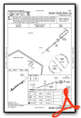
IFR Chart of KPYG
Enroute Charts at SkyVector.com
Location Information for KPYG
Coordinates: N34°44.53' / W80°20.71'Located 03 miles SE of Pageland, South Carolina on 20 acres of land. View all Airports in South Carolina.
Surveyed Elevation is 574 feet MSL.
Operations Data
|
|
Airport Communications
| CHARLOTTE APPROACH: | 120.05 307.8 |
|---|---|
| CHARLOTTE DEPARTURE: | 120.05 307.8 |
| CTAF: | 122.900 |
| AWOS-3 at CQW (19.0 E): | 124.825 843-537-3301 |
| AWOS-3 at AFP (21.2 NE): | 119.325 704-695-0623 |
| ASOS at EQY (21.4 NW): | 135.775 704-283-5185 |
Nearby Navigation Aids
|
| ||||||||||||||||||||||||||||||||||||||||||||||||||||||||||||


Runway 06/24
| Dimensions: | 3396 x 60 feet / 1035 x 18 meters | |
|---|---|---|
| Surface: | Asphalt in Good Condition | |
| Weight Limits: | S-12 | |
| Edge Lighting: | Medium Intensity | |
| Runway 06 | Runway 24 | |
| Coordinates: | N34°44.35' / W80°20.97' | N34°44.71' / W80°20.45' |
| Elevation: | 549.9 | 574.9 |
| Traffic Pattern: | Left | Left |
| Runway Heading: | 50° True | 230° True |
| Markings: | Non-Precision Instrument in good condition. | Non-Precision Instrument in good condition. |
| Glide Slope Indicator | P2L (3.00° Glide Path Angle) | P2L (3.00° Glide Path Angle) |
| REIL: | Yes | Yes |
| Obstacles: | CONTROLLING OBSTRUCTION EXCEEDS A 45 DEGREE SLOPE |
27 ft Pole 181 ft from runway, 186 ft right of center 31 FT PWR POLE 182 FT FM RWY END, 188 FT R OF CNTRLN. ACCESS ROAD 27 FEET FROM RWY END. |
Services Available
| Fuel: | 100LL (blue) |
|---|---|
| Transient Storage: | Tiedowns |
| Airframe Repair: | NONE |
| Engine Repair: | NONE |
| Bottled Oxygen: | NONE |
| Bulk Oxygen: | NONE |
Ownership Information
| Ownership: | Publicly owned | |
|---|---|---|
| Owner: | TOWN OF PAGELAND | |
| 307 E MCGREGOR STREET | ||
| PAGELAND, SC 29728-1951 | ||
| 843-672-7292 | ||
| Manager: | SHANE SLIGH | |
| 307 E MCGREGOR STREET, 126 N PEARL ST | ||
| PAGELAND, SC 29728-1951 | ||
| 843-672-7292 | ||
Other Remarks
- FOR CD CTC CHARLOTTE APCH AT 704-359-0241.
- 0LL SELF SVC FUEL AVBL 24 HRS.
- ACTVT PAPI RWY 6 & 24 - CTAF.
Weather Minimums

Instrument Approach Procedure (IAP) Charts

Nearby Airports with Instrument Procedures
| ID | Name | Heading / Distance | ||
|---|---|---|---|---|
 |
KCQW | Cheraw Municipal/Lynch Bellinger Field Airport | 095° | 19.3 |
|
N52 | Jaars-Townsend Airport | 290° | 21.2 |
|
KAFP | Anson County/Jeff Cloud Field Airport | 038° | 21.3 |
|
KEQY | Charlotte/Monroe Exec Airport | 320° | 21.4 |
|
KHVS | Hartsville Regional Airport | 151° | 23.2 |
|
KLKR | Lancaster County-Mc Whirter Field Airport | 267° | 25.2 |
|
KUDG | Darlington County Airport | 127° | 28.8 |
|
KCDN | Woodward Field Airport | 201° | 29.5 |
|
KRCZ | Richmond County Airport | 072° | 30.3 |
|
KBBP | Marlboro County Jetport/H E Avent Field Airport | 103° | 31.1 |
|
KUZA | Rock Hill/York County/Bryant Field Airport | 292° | 38.1 |
|
KCLT | Charlotte/Douglas International Airport | 313° | 41.1 |
Airport Images
Do you have a recent image of this airport? Upload it here!


