Login
Register


43A
Montgomery County Airport
Official FAA Data Effective 2026-01-22 0901Z
Chart Supplement

VFR Chart of 43A
Sectional Charts at SkyVector.com
IFR Chart of 43A
Enroute Charts at SkyVector.com
Location Information for 43A
Coordinates: N35°23.08' / W79°47.42'Located 00 miles NE of Star, North Carolina on 83 acres of land. View all Airports in North Carolina.
Surveyed Elevation is 632 feet MSL.
Operations Data
|
|
Airport Communications
| FAYETTEVILLE APPROACH: | 127.8 343.725 |
|---|---|
| FAYETTEVILLE DEPARTURE: | 127.8 343.725 |
| UNICOM: | 122.800 |
| CTAF: | 122.800 |
| AWOS-3 at HBI (17.0 N): | 119.275 336-626-7933 |
| AWOS-3 at VUJ (17.8 W): | 128.175 704-986-2097 |
| AWOS-3PT at SOP (21.3 SE): | 127.575 910-692-4287 |
Nearby Navigation Aids
|
| ||||||||||||||||||||||||||||||||||||||||||||||||||||||||||||


Runway 03/21
| Dimensions: | 4002 x 75 feet / 1220 x 23 meters | |
|---|---|---|
| Surface: | Asphalt in Excellent Condition | |
| Weight Limits: | S-20 | |
| Edge Lighting: | Medium Intensity | |
| Runway 03 | Runway 21 | |
| Coordinates: | N35°22.77' / W79°47.56' | N35°23.39' / W79°47.27' |
| Elevation: | 572.7 | 632.5 |
| Traffic Pattern: | Left | Left |
| Runway Heading: | 21° True | 201° True |
| Displaced Threshold: | 458 Feet | |
| Markings: | Non-Precision Instrument in good condition. | Non-Precision Instrument in good condition. |
| Glide Slope Indicator | P2L (3.50° Glide Path Angle) | P2L (4.00° Glide Path Angle) |
| Obstacles: | 43 ft Trees 1453 ft from runway, 46 ft right of center | 26 ft Pole 456 ft from runway, 108 ft left of center APCH RATIO 24:1 TO DTHR. |
Services Available
| Fuel: | 100LL (blue) |
|---|---|
| Transient Storage: | Tiedowns |
| Airframe Repair: | NONE |
| Engine Repair: | NONE |
| Bottled Oxygen: | NONE |
| Bulk Oxygen: | NONE |
Ownership Information
| Ownership: | Publicly owned | |
|---|---|---|
| Owner: | MONTGOMERY COUNTY | |
| PO BOX 425 | ||
| TROY, NC 27371 | ||
| 910-576-4221 | ||
| Manager: | KEVIN MCNEILL | |
| PO BOX 425 | ||
| TROY, NC 27371 | ||
| (910) 220-1218 | MGR PHONE 910-220-1218. | |
Other Remarks
- CTN: DEER ON AND INVOF RWY.
- UNMARKED 40 FT PLINE 350-750 FT FM THR RWY 21 ACROSS & L OF CNTRLN.
- 20-25 FT DEPRESSION 180 FT SOUTH OF RWY 03 THR ON CNTRLN.
- RWY 03 HAS UPHILL GRADE.
- 35-40 FT DROP-OFF 80 FT WEST OF RWY 03 CNTRLN; 30 FT DROP-OFF 300 FT FM RWY 21 THR ON CNTRLN; 30 FT DROP-OFF 80 FT RIGHT OF RWY 21 CNTRLN.
- FOR CD CTC FAYETTEVILLE APCH AT 910-484-8012.
- RWY 21 HAS A PARALLEL GRAVEL DRIVEWAY 130 FT RIGHT OF CNTRLN.
- 0LL AVGAS 100LL 24 HR SELF SVC WITH CREDIT CARD.
- ACTVT PAPI RWY 03 & 21; MIRL RWY 03/21 - CTAF.
Weather Minimums

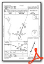
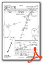
Instrument Approach Procedure (IAP) Charts
Nearby Airports with Instrument Procedures
| ID | Name | Heading / Distance | ||
|---|---|---|---|---|
 |
KHBI | Asheboro Regional Airport | 342° | 17.0 |
|
KVUJ | Stanly County Airport | 276° | 17.8 |
|
KSOP | Moore County Airport | 113° | 21.6 |
|
KSCR | Siler City Municipal Airport | 036° | 23.7 |
|
KAFP | Anson County/Jeff Cloud Field Airport | 212° | 26.0 |
|
KRCZ | Richmond County Airport | 177° | 29.6 |
|
KEXX | Davidson County Exec Airport | 313° | 34.6 |
|
KTTA | Raleigh Exec Jetport At Sanford-Lee County Airport | 070° | 35.8 |
|
5W4 | P K Airpark Airport | 126° | 36.7 |
|
KRUQ | Mid-Carolina Regional Airport | 293° | 39.0 |
|
KPOB | Pope AAF Airport | 108° | 40.2 |
|
KCQW | Cheraw Municipal/Lynch Bellinger Field Airport | 191° | 41.1 |
Airport Images
Do you have a recent image of this airport? Upload it here!


