Login
Register


AIK
Aiken Regional Airport
Official FAA Data Effective 2026-02-19 0901Z
Chart Supplement

VFR Chart of KAIK
Sectional Charts at SkyVector.com
IFR Chart of KAIK
Enroute Charts at SkyVector.com
Location Information for KAIK
Coordinates: N33°38.96' / W81°41.10'Located 05 miles N of Aiken, South Carolina on 700 acres of land. View all Airports in South Carolina.
Surveyed Elevation is 528 feet MSL.
Operations Data
|
|
Airport Communications
| AWOS-3PT: | 118.025 Tel. 803-643-8664 |
|---|---|
| AUGUSTA APPROACH: | 119.15 284.625 124.15 338.2 |
| AUGUSTA DEPARTURE: | 119.15 284.625 124.15 338.2 |
| CLEARANCE DELIVERY: | 126.075 126.075 ;WHEN AUGUSTA APCH CTL CLSD |
| UNICOM: | 122.800 |
| CTAF: | 122.800 |
| ASOS at DNL (20.9 SW): | 135.275 706-481-8629 |
| ATIS at AGS (21.8 SW): | 132.75 |
| ASOS at AGS (21.8 SW): | 706-250-6089 |
- APCH/DEP SVC PRVDD BY COLUMBIA APCH CTL ON FREQS 124.15/338.2 WHEN AUGUSTA APCH CTL CLSD.
Nearby Navigation Aids
|
| ||||||||||||||||||||||||||||||||||||||||||||||||||||||||||||


Runway 07/25
| Dimensions: | 5500 x 100 feet / 1676 x 30 meters | |
|---|---|---|
| Surface: | Asphalt in Good Condition | |
| Weight Limits: | 21 /F/C/X/T, S-55, D-75, ST-140 | |
| Edge Lighting: | Medium Intensity | |
| Runway 07 | Runway 25 | |
| Coordinates: | N33°38.76' / W81°41.75' | N33°39.21' / W81°40.80' |
| Elevation: | 514.6 | 493.5 |
| Traffic Pattern: | Left | Left |
| Runway Heading: | 60° True | 240° True |
| Markings: | Precision Instrument in good condition. | Non-Precision Instrument in good condition. |
| Glide Slope Indicator | P2L (3.00° Glide Path Angle) | P2L (3.00° Glide Path Angle) |
| Approach Lights: | ODALS Omnidirectional Approach Lighting System | |
| REIL: | Yes | |
Runway 01/19
| Dimensions: | 3800 x 75 feet / 1158 x 23 meters | |
|---|---|---|
| Surface: | Asphalt / Aggregate Friction Seal Coated in Fair Condition | |
| Weight Limits: | 20 /F/C/X/T, S-54, D-75, ST-139 | |
| Runway 01 | Runway 19 | |
| Coordinates: | N33°38.61' / W81°40.85' | N33°39.24' / W81°40.85' |
| Elevation: | 528.1 | 492.9 |
| Traffic Pattern: | Left | Left |
| Runway Heading: | 0 | 180° True |
| Markings: | Basic in good condition. | Basic in good condition. |
| Obstacles: | 52 ft Tree 574 ft from runway, 119 ft right of center | |
Services Available
| Fuel: | 100LL (blue), Jet-A |
|---|---|
| Transient Storage: | Hangars,Tiedowns |
| Airframe Repair: | MINOR |
| Engine Repair: | MINOR |
| Bottled Oxygen: | NONE |
| Bulk Oxygen: | NONE |
| Other Services: | PILOT INSTRUCTION,AIRCRAFT RENTAL |
Ownership Information
| Ownership: | Publicly owned | |
|---|---|---|
| Owner: | CITY OF AIKEN | |
| PO BOX 1177 | ||
| AIKEN, SC 29801 | ||
| (803) 642-7654 | ||
| Manager: | CHRISTOPHER MCCAULEY | |
| 129 AVIATION BLVD, 214 PARK AVENUE, SW | ||
| AIKEN, SC 29805 | ||
| 803-502-4860 | ||
Other Remarks
- FOR CD IF UNA TO CTC ON FSS FREQ, CTC AUGUSTA APCH AT 706-771-1777, WHEN APCH CLSD CTC COLUMBIA APCH AT 803-822-4511.
- ACTVT ODALS RWY 25; MIRL RWY 07/25 - CTAF. PAPI RWY 07 & 25 OPER CONSLY.
Weather Minimums

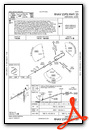
Instrument Approach Procedure (IAP) Charts


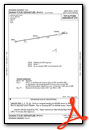
Departure Procedure (DP) Charts


Nearby Airports with Instrument Procedures
| ID | Name | Heading / Distance | ||
|---|---|---|---|---|
 |
6J4 | Saluda County Airport | 341° | 17.5 |
|
KDNL | Daniel Field Airport | 238° | 20.9 |
|
KAGS | Augusta Regional At Bush Field Airport | 220° | 21.8 |
|
6J0 | Lexington County Airport | 068° | 23.6 |
|
KBNL | Barnwell Regional Airport | 147° | 27.8 |
|
KCAE | Columbia Metro Airport | 058° | 33.2 |
|
99N | Bamberg County Airport | 125° | 35.6 |
|
KCUB | Jim Hamilton L B Owens Airport | 060° | 39.5 |
|
KEOE | Newberry County Airport | 003° | 39.6 |
|
KBXG | Burke County Airport | 203° | 39.8 |
|
KHQU | Thomson/Mcduffie County Airport | 260° | 42.3 |
|
KOGB | Orangeburg Municipal Airport | 105° | 43.0 |

")


