Login
Register


6J4
Saluda County Airport
Official FAA Data Effective 2026-02-19 0901Z
Chart Supplement

VFR Chart of 6J4
Sectional Charts at SkyVector.com
IFR Chart of 6J4
Enroute Charts at SkyVector.com
Location Information for 6J4
Coordinates: N33°55.61' / W81°47.68'Located 04 miles S of Saluda, South Carolina on 59 acres of land. View all Airports in South Carolina.
Estimated Elevation is 539 feet MSL.
Operations Data
|
|
Airport Communications
| AUGUSTA APPROACH: | 119.15 126.8 124.15 ;WHEN AUGUSTA APCH CTL CLSD |
|---|---|
| AUGUSTA DEPARTURE: | 119.15 126.8 124.15 ;WHEN AUGUSTA APCH CTL CLSD |
| CTAF: | 122.900 |
| AWOS-3PT at AIK (17.5 S): | 118.025 803-643-8664 |
| AWOS-3 at EOE (24.0 N): | 124.275 803-276-2419 |
| ASOS at GRD (26.3 NW): | 121.125 864-388-9115 |
Nearby Navigation Aids
|
| ||||||||||||||||||||||||||||||||||||||||||||||||||||||||||||


Runway 01/19
| Dimensions: | 3189 x 60 feet / 972 x 18 meters | |
|---|---|---|
| Surface: | Asphalt in Good Condition | |
| Weight Limits: | S-11 | |
| Edge Lighting: | Medium Intensity | |
| Runway 01 | Runway 19 | |
| Coordinates: | N33°55.35' / W81°47.73' | N33°55.87' / W81°47.63' |
| Elevation: | 536.8 | 522.3 |
| Traffic Pattern: | Left | Left |
| Runway Heading: | 9° True | 189° True |
| Markings: | Non-Precision Instrument in good condition. | Non-Precision Instrument in good condition. |
| Glide Slope Indicator | P2L (3.00° Glide Path Angle) | P2L |
| Obstacles: | 64 ft Tree 1891 ft from runway, 220 ft left of center | 133 ft Tree 2362 ft from runway, 319 ft right of center |
Services Available
| Fuel: | 100LL (blue) |
|---|---|
| Transient Storage: | Hangars,Tiedowns |
| Airframe Repair: | MAJOR |
| Engine Repair: | MAJOR |
| Bottled Oxygen: | NONE |
| Bulk Oxygen: | NONE |
Ownership Information
| Ownership: | Publicly owned | |
|---|---|---|
| Owner: | SALUDA COUNTY | |
| 400 WEST HIGHLAND STREET | ||
| SALUDA, SC 29138 | ||
| 864-445-4500 | ||
| Manager: | JILL WARREN | |
| 111 LAW ENFORCEMENT DRIVE | ||
| SALUDA, SC 29138 | ||
| 864-445-2529 | ||
Other Remarks
- 30 FT DROP OFF N END OF RWY 01.
- FOR CD CTC AUGUSTA APCH AT 706-771-1777. WHEN AUGUSTA APCH CLSD, FOR CD CTC COLUMBIA APCH AT 803-822-4511.
- ACTVT PAPI RWY 01 & 19; MIRL RWY 01/19 - CTAF.
Weather Minimums

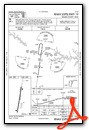
Instrument Approach Procedure (IAP) Charts

Nearby Airports with Instrument Procedures
| ID | Name | Heading / Distance | ||
|---|---|---|---|---|
 |
KAIK | Aiken Regional Airport | 161° | 17.5 |
|
KEOE | Newberry County Airport | 018° | 24.2 |
|
KGRD | Greenwood County Airport | 317° | 26.5 |
|
6J0 | Lexington County Airport | 105° | 28.5 |
|
KDNL | Daniel Field Airport | 204° | 30.2 |
|
KCAE | Columbia Metro Airport | 088° | 33.7 |
|
KAGS | Augusta Regional At Bush Field Airport | 194° | 34.4 |
|
KLUX | Laurens County Airport | 347° | 35.6 |
|
KCUB | Jim Hamilton L B Owens Airport | 086° | 40.0 |
|
KFDW | Fairfield County Airport | 055° | 41.4 |
|
KHQU | Thomson/Mcduffie County Airport | 236° | 43.3 |
|
KBNL | Barnwell Regional Airport | 152° | 45.0 |
Airport Images

By: SaludaCountyAirport


