Login
Register


6J0
Lexington County Airport
Official FAA Data Effective 2026-02-19 0901Z
Chart Supplement

VFR Chart of 6J0
Sectional Charts at SkyVector.com
IFR Chart of 6J0
Enroute Charts at SkyVector.com
Location Information for 6J0
Coordinates: N33°47.68' / W81°14.75'Located 02 miles N of Pelion, South Carolina on 110 acres of land. View all Airports in South Carolina.
Surveyed Elevation is 451 feet MSL.
Operations Data
|
|
Airport Communications
| COLUMBIA APPROACH: | 124.15 338.2 |
|---|---|
| COLUMBIA DEPARTURE: | 124.15 338.2 |
| UNICOM: | 123.000 |
| CTAF: | 123.000 |
| ATIS at CAE (10.7 NE): | 120.15 |
| ASOS at CAE (10.9 NE): | 803-369-6879 |
| ASOS at CUB (16.4 NE): | 118.675 803-929-0665 |
Nearby Navigation Aids
|
| ||||||||||||||||||||||||||||||||||||||||||||||||||||||||||||


Runway 18/36
| Dimensions: | 4335 x 75 feet / 1321 x 23 meters | |
|---|---|---|
| Surface: | Concrete in Excellent Condition | |
| Weight Limits: | S-12 | |
| Edge Lighting: | Medium Intensity | |
| Runway 18 | Runway 36 | |
| Coordinates: | N33°48.03' / W81°14.82' | N33°47.33' / W81°14.68' |
| Elevation: | 450.5 | 451.1 |
| Traffic Pattern: | Left | Left |
| Runway Heading: | 171° True | 351° True |
| Markings: | Non-Precision Instrument in good condition. | Non-Precision Instrument in good condition. |
| Glide Slope Indicator | P2L (3.00° Glide Path Angle) | |
| Obstacles: | 60 ft Tree 1053 ft from runway, 329 ft right of center | 14 ft Pole 603 ft from runway, 227 ft left of center |
Services Available
| Fuel: | 100LL (blue) |
|---|---|
| Transient Storage: | Tiedowns |
| Airframe Repair: | NONE |
| Engine Repair: | NONE |
| Bottled Oxygen: | NONE |
| Bulk Oxygen: | NONE |
Ownership Information
| Ownership: | Publicly owned | |
|---|---|---|
| Owner: | LEXINGTON COUNTY | |
| 212 SOUTH LAKE DRIVE | ||
| LEXINGTON, SC 29072 | ||
| 803-785-8100 | ||
| Manager: | TIM SHUMPERT | |
| 440 BALL PARK ROAD | ||
| LEXINGTON, SC 29072 | ||
| 803-600-9313 | ||
Other Remarks
- PLINE 800 FT FROM THLD RWY END 36; MKD WITH RED BALLS.
- ACES INTO TRML BLDG, USE THE KEY PAD AND ENTER THE UNICOM FREQ.
- FOR CD CTC COLUMBIA APCH AT 803-822-5242 OR 803-822-5040.
- ACTVT PAPI RWY 36; MIRL RWY 18/36 - CTAF.
Weather Minimums

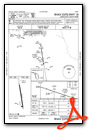
Instrument Approach Procedure (IAP) Charts


Nearby Airports with Instrument Procedures
| ID | Name | Heading / Distance | ||
|---|---|---|---|---|
 |
KCAE | Columbia Metro Airport | 036° | 10.7 |
|
KCUB | Jim Hamilton L B Owens Airport | 049° | 16.4 |
|
KMMT | Mc Entire Jngb Airport | 071° | 23.5 |
|
KAIK | Aiken Regional Airport | 248° | 23.6 |
|
KOGB | Orangeburg Municipal Airport | 136° | 28.0 |
|
6J4 | Saluda County Airport | 286° | 28.5 |
|
99N | Bamberg County Airport | 166° | 30.2 |
|
KFDW | Fairfield County Airport | 012° | 32.0 |
|
KBNL | Barnwell Regional Airport | 192° | 32.9 |
|
KEOE | Newberry County Airport | 327° | 36.6 |
|
KSSC | Shaw AFB Airport | 074° | 40.2 |
|
KAGS | Augusta Regional At Bush Field Airport | 234° | 44.1 |
Airport Images
Do you have a recent image of this airport? Upload it here!


