Login
Register
DNL
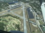
Daniel Field Airport
Official FAA Data Effective 2025-12-25 0901Z
VFR Chart of KDNL
Sectional Charts at SkyVector.com
IFR Chart of KDNL
Enroute Charts at SkyVector.com
Location Information for KDNL
Coordinates: N33°27.99' / W82°2.36'Located 01 miles W of Augusta, Georgia on 146 acres of land. View all Airports in Georgia.
Surveyed Elevation is 422 feet MSL.
Operations Data
|
|
Airport Communications
| ASOS: | 135.275 Tel. 706-481-8629 |
|---|---|
| AUGUSTA APPROACH: | 126.8 270.3 |
| AUGUSTA DEPARTURE: | 126.8 270.3 |
| CTAF: | 123.050 |
| UNICOM: | 123.050 |
| ATIS at AGS (6.9 SE): | 132.75 |
| ASOS at AGS (6.9 SE): | 706-250-6089 |
| AWOS-3PT at AIK (21.0 NE): | 118.025 803-643-8664 |
- APCH/DEP SVC PRVDD BY ATLANTA ARTCC ON FREQS 128.1/322.325 (AUGUSTA RCAG) WHEN AUGUSTA APCH CTL CLSD.
- TO OBTAIN CLNCS & CNL FLIGHT PLANS FROM GND CONTACT APCH CTL.
Nearby Navigation Aids
|
| ||||||||||||||||||||||||||||||||||||||||||||||||||||||||||||
Runway 05/23
| Dimensions: | 4002 x 100 feet / 1220 x 30 meters | |
|---|---|---|
| Surface: | Asphalt / Grooved in Good Condition | |
| Weight Limits: | S-30 | |
| Edge Lighting: | Medium Intensity | |
| Runway 05 | Runway 23 | |
| Coordinates: | N33°27.66' / W82°2.62' | N33°28.12' / W82°2.05' |
| Elevation: | 373.9 | 422.3 |
| Traffic Pattern: | Left | Left |
| Runway Heading: | 46° True | 226° True |
| Displaced Threshold: | 202 Feet | 298 Feet |
| Markings: | Non-Precision Instrument in good condition. | Non-Precision Instrument in good condition. |
| Glide Slope Indicator | P2L (3.00° Glide Path Angle) | P2L (3.30° Glide Path Angle) |
| REIL: | Yes | Yes |
| Obstacles: | 10 ft Tree 280 ft from runway, 243 ft right of center APCH RATIO 50:1 TO DSPLCD THLD. |
15 ft Road 201 ft from runway, 80 ft right of center APCH RATIO 16:1 TO DSPLCD THLD; 34FT LIGHT POLE, 577 FT FROM THLD, 213 FT RIGHT. 6 FT FENCE 190 FT FM THLD 125 FT RIGHT. |
Runway 11/29
| Dimensions: | 3733 x 100 feet / 1138 x 30 meters | |
|---|---|---|
| Surface: | Asphalt in Good Condition | |
| Weight Limits: | S-30 | |
| Edge Lighting: | Medium Intensity | |
| Runway 11 | Runway 29 | |
| Coordinates: | N33°28.18' / W82°2.75' | N33°28.04' / W82°2.04' |
| Elevation: | 421.4 | 418.7 |
| Traffic Pattern: | Left | Left |
| Runway Heading: | 104° True | 284° True |
| Displaced Threshold: | 326 Feet | 314 Feet |
| Declared Distances: | TORA:3733 TODA:3733 ASDA:3733 LDA:3407 | TORA:3733 TODA:3733 ASDA:3733 LDA:3419 |
| Markings: | Non-Precision Instrument in good condition. | Non-Precision Instrument in good condition. |
| Glide Slope Indicator | P4L (3.50° Glide Path Angle) RWY 11 PAPI UNUSBL BYD 3 DEG LEFT OF RWY CNTRLN, PAPI IS BAFFLED. | |
| REIL: | Yes | |
| Obstacles: | 25 ft Road 201 ft from runway, 145 ft left of center APCH RATIO 0:1 TO DSPLCD THLD; 20 FT ROAD/FENCE AT DSPLCD THLD & 245 FT LEFT. 6 FT FENCE 190 FT FM THLD 94 FT RIGHT. |
15 ft Road 201 ft from runway, 180 ft left of center APCH RATIO 13:1 TO DSPLCD THLD; +55 FT TREES 715 FT FROM THLD, 139 FT LEFT. |
Services Available
| Fuel: | 100LL (blue), Jet A-1+ |
|---|---|
| Transient Storage: | Hangars,Tiedowns |
| Airframe Repair: | MAJOR |
| Engine Repair: | MAJOR |
| Bottled Oxygen: | HIGH/LOW |
| Bulk Oxygen: | HIGH/LOW |
| Other Services: | AIR AMBULANCE SERVICES,AVIONICS,CHARTER SERVICE,PILOT INSTRUCTION,AIRCRAFT RENTAL,AIRCRAFT SALES |
Ownership Information
| Ownership: | Publicly owned | |
|---|---|---|
| Owner: | AUGUSTA-RICHMOND CO | |
| 535 TELFAIR STREET | ||
| AUGUSTA, GA 30901 | ||
| (706) 821-2300 | ||
| Manager: | STEVE GAY, PRES | |
| AUGUSTA AVIATION (FBO), 1775 HIGHLAND AVE | ||
| AUGUSTA, GA 30904 | ||
| 706-733-8970 | ||
Other Remarks
- PILOTS SHOULD BE ALERT FOR TURBO-JET TFC TRANSITING THE TFC AREA ENR TO BUSH FLD 6 MILES SOUTH.
- ACTVT REIL RWY 05, 11, 23; PAPI RWY 05, 11, & 23; MIRL RWY 05/23 & 11/29 - CTAF.
Weather Minimums
Instrument Approach Procedure (IAP) Charts
Departure Procedure (DP) Charts
Nearby Airports with Instrument Procedures
| ID | Name | Heading / Distance | ||
|---|---|---|---|---|
 |
KAGS | Augusta Regional At Bush Field Airport | 146° | 6.9 |
 |
KAIK | Aiken Regional Airport | 058° | 20.9 |
 |
KHQU | Thomson/Mcduffie County Airport | 279° | 24.3 |
 |
KBXG | Burke County Airport | 176° | 25.6 |
 |
6J4 | Saluda County Airport | 023° | 30.2 |
 |
2J3 | Louisville Municipal Airport | 211° | 33.6 |
 |
2J5 | Millen Airport | 173° | 34.6 |
 |
KBNL | Barnwell Regional Airport | 110° | 35.0 |
 |
KIIY | Washington/Wilkes County Airport | 295° | 43.1 |
 |
6J0 | Lexington County Airport | 063° | 44.3 |
 |
KGRD | Greenwood County Airport | 352° | 47.3 |
 |
99N | Bamberg County Airport | 101° | 47.8 |


