Login
Register
AK7
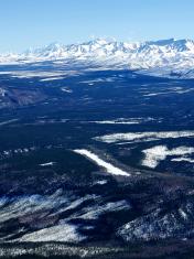
Gold King Creek Airport
Official FAA Data Effective 2025-11-27 0901Z
VFR Chart of PAAN
Sectional Charts at SkyVector.com
IFR Chart of PAAN
Enroute Charts at SkyVector.com
Location Information for PAAN
Coordinates: N64°11.88' / W147°55.72'Located 39 miles SE of Fairbanks, Alaska on 30 acres of land. View all Airports in Alaska.
Estimated Elevation is 1720 feet MSL.
Operations Data
|
|
Airport Communications
| CTAF: | 122.900 |
|---|---|
| ATIS at EIL (35.3 NE): | 119.9 |
| ASOS at ENN (36.7 NW): | 125.2 907-832-5689 |
| ASOS at FAI (37.1 N): | 124.4 907-621-7609 |
Nearby Navigation Aids
|
| ||||||||||||||||||||||||||||||||||||||||||
Runway 09/27
| Dimensions: | 2558 x 17 feet / 780 x 5 meters | |
|---|---|---|
| Surface: | Gravel-Dirt in Fair Condition ROCKS UP TO 6 INCHES ON RY SFC. | |
| Runway 09 | Runway 27 | |
| Coordinates: | N64°11.99' / W147°56.13' | N64°11.77' / W147°55.31' |
| Runway Heading: | 122° True | 302° True |
| Obstacles: | 38 ft Trees 0 ft from runway, 110 ft right of center | 15 ft Brush 0 ft from runway, 69 ft right of center |
Ownership Information
| Ownership: | Publicly owned | |
|---|---|---|
| Owner: | ALASKA DOT&PF NORTHERN REGION | |
| 2301 PEGER ROAD | ||
| FAIRBANKS, AK 99709 | ||
| 907-451-2200 | ||
| Manager: | JASON LUDINGTON | |
| 2301 PEGER ROAD | ||
| FAIRBANKS, AK 99709 | ||
| (907) 451-5280 | ||
Other Remarks
- GOLD KING CREEK
- RY CONDITION NOT MONITORED; RECOMMEND VISUAL INSP PRIOR TO LANDING.
- NO SVCS AVBL.
- 20 FT TREES ON BOTH SIDES OF RWY WITHIN 60-70 FT OF CENTERLINE.
Nearby Airports with Instrument Procedures
| ID | Name | Heading / Distance | ||
|---|---|---|---|---|
 |
PAHV | Healy River Airport | 234° | 33.9 |
 |
PAEI | Eielson AFB Airport | 037° | 35.4 |
 |
PANN | Nenana Municipal Airport | 305° | 36.5 |
 |
PAFA | Fairbanks International Airport | 002° | 37.2 |
 |
PABI | Allen AAF Airport | 100° | 59.4 |
 |
PAML | Manley Hot Springs Airport | 305° | 84.9 |
 |
PATK | Talkeetna Airport | 208° | 127.3 |


