Login
Register


FAI
Fairbanks International Airport
Official FAA Data Effective 2025-11-27 0901Z
Chart Supplement

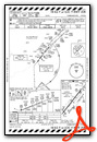
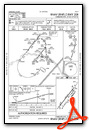
PAFA Airport Diagram

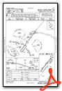
VFR Chart of PAFA
Sectional Charts at SkyVector.com
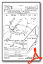
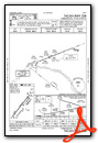
IFR Chart of PAFA
Enroute Charts at SkyVector.com
Location Information for PAFA
Coordinates: N64°48.92' / W147°51.40'Located 03 miles SW of Fairbanks, Alaska on 3470 acres of land. View all Airports in Alaska.
Surveyed Elevation is 439 feet MSL.
TFC PAT ALT (SINGLE ENGINE RECIPROCATING ACFT) 1500 FT MSL. TFC PAT ALT (ALL MULTI-ENGINE, LARGE AND TURBINE-POWERED ACFT) 2000 FT MSL.
Operations Data
|
|
Airport Communications
| ATIS: | 124.4 (907-456-1244) |
|---|---|
| ASOS: | 124.4 Tel. 907-621-7609 |
| FAIRBANKS TOWER: | 118.3 257.8 |
| FAIRBANKS GROUND: | 121.9 |
| FAIRBANKS APPROACH: | 119.85 125.35 ;180-359 127.1 ;360-179 251.1 ;360-179 363.2 ;180-359 |
| FAIRBANKS DEPARTURE: | 125.35 ;180-359 127.1 ;360-179 251.1 ;360-179 327.1 363.2 ;180-359 |
| IC: | 125.35 ;180-359 363.2 ;180-359 |
| CLEARANCE DELIVERY: | 127.6 |
| TRSA: | 125.35 ;180-359 127.1 ;360-179 251.1 ;360-179 363.2 ;180-359 |
| EMERG: | 121.5 243.0 |
| ATIS at FBK (6.3 E): | 134.25 |
| ATIS at EIL (21.3 SE): | 119.9 |
| ASOS at ENN (35.5 SW): | 125.2 907-832-5689 |
- SECTORIZATION BASED ON CHENA NDB.
- COMMUNICATIONS PRVDD BY FAIRBANKS FSS ON FREQS 124.1 & 132.65.
Nearby Navigation Aids
|
| ||||||||||||||||||||||||||||||||||||||||||


Runway 02L/20R
| Dimensions: | 11800 x 150 feet / 3597 x 46 meters | |
|---|---|---|
| Surface: | Asphalt / Grooved in Good Condition | |
| Weight Limits: | S-75, D-220, ST-580, DT-1100
PCR VALUE: 780/F/B/X/T
| |
| Edge Lighting: | High Intensity | |
| Runway 02L | Runway 20R | |
| Coordinates: | N64°48.16' / W147°53.15' | N64°49.68' / W147°50.35' |
| Elevation: | 435.6 | 438.9 |
| Traffic Pattern: | Left | Left |
| Runway Heading: | 38° True | 218° True |
| Displaced Threshold: | 750 Feet | 750 Feet |
| Declared Distances: | TORA:11800 TODA:12800 ASDA:11800 LDA:11050 | TORA:11800 TODA:12800 ASDA:11800 LDA:11050 |
| Markings: | Precision Instrument in good condition. | Precision Instrument in good condition. |
| Glide Slope Indicator | P4L (3.00° Glide Path Angle) | P4L (3.00° Glide Path Angle) UNUSBL BYD 8 DEGS RIGHT OF CNTRLN. |
| RVR Equipment | Touchdown Midfield Rollout | Touchdown Midfield Rollout |
| Approach Lights: | ALSF2 Standard 2,400 Foot High-intensity Approach Lighting System with sequenced flashers, CATEGORY II or III Configuration. | MALSR 1,400 Foot Medium-intensity Approach Lighting System with runway alignment indicator lights. |
| Centerline Lights: | Yes | Yes |
| Obstacles: | 72 ft Tree 2711 ft from runway, 652 ft left of center | 86 ft Tree 3096 ft from runway, 430 ft right of center |
Runway 02W/20W
RWY 02W/20W NOT AVBL FOR PART 121/PART 380 OPS WITH SKED PAX CARRYING OPS MORE THAN 9 PAX SEATS AND NON-SKED PAX CARRYING OPS MORE THAN 30 PAX SEATS. CTLD; APREQ - ATCT 118.3. CTC CD ASAP AFT ENG START. FROZEN IN WINTER; SFC UNMNT. THR BUOYS 500 FT FM N & S SHORES & MARK WATERLANE. STEP TAX OUTSIDE OF WATERLANE NA. E OF WATERLANE UNCTLD; TAX AT PILOT DISCRETION. | ||
| Dimensions: | 5400 x 100 feet / 1646 x 30 meters | |
|---|---|---|
| Surface: | Water | |
| Runway 02W | Runway 20W | |
| Coordinates: | N64°48.97' / W147°51.28' | N64°49.66' / W147°49.99' |
| Elevation: | 423.4 | 423.4 |
| Traffic Pattern: | Left | Left |
| Runway Heading: | 38° True | 218° True |
| Markings: | Buoys in good condition. | Buoys in good condition. |
| Obstacles: | 14 ft Fence 553 ft from runway, 170 ft left of center | 11 ft Fence 505 ft from runway |
Runway 02R/20L
RWY 02R/20L NOT AVBL FOR PART 121/PART 380 OPS WITH SKED PAX CARRYING OPS MORE THAN 9 PAX SEATS AND NON-SKED PAX CARRYING OPS MORE THAN 30 PAX SEATS. | ||
| Dimensions: | 4510 x 75 feet / 1375 x 23 meters | |
|---|---|---|
| Surface: | Asphalt in Good Condition | |
| Weight Limits: | S-21, D-40
PCR VALUE: 46/F/B/X/T
| |
| Edge Lighting: | Medium Intensity | |
| Runway 02R | Runway 20L | |
| Coordinates: | N64°48.01' / W147°52.54' | N64°48.60' / W147°51.47' |
| Elevation: | 433.5 | 434.5 |
| Traffic Pattern: | Right | |
| Runway Heading: | 38° True | 218° True |
| Markings: | Non-Precision Instrument in good condition. | Non-Precision Instrument in good condition. |
| Glide Slope Indicator | P4L (3.00° Glide Path Angle) | P4L (3.00° Glide Path Angle) |
| REIL: | Yes | |
| Obstacles: | 79 ft Trees 2175 ft from runway | |
Runway 02/20
RWY 02/20 NOT AVBL FOR PART 121/PART 380 OPS WITH SKED PAX CARRYING OPS MORE THAN 9 PAX SEATS AND NON-SKED PAX CARRYING OPS MORE THAN 30 PAX SEATS. SUMMER & SKI STRIP WINTER USE; AVBL LCL NOTAM & ATCT BFR ARR OR DEP. | ||
| Dimensions: | 2900 x 75 feet / 884 x 23 meters | |
|---|---|---|
| Surface: | Gravel | |
| Runway 02 | Runway 20 | |
| Coordinates: | N64°48.96' / W147°50.79' | N64°49.34' / W147°50.10' |
| Elevation: | 433.0 | 433.6 |
| Runway Heading: | 38° True | 218° True |
Services Available
| Fuel: | 100LL (blue), Jet A-1 |
|---|---|
| Transient Storage: | Hangars |
| Airframe Repair: | MAJOR |
| Engine Repair: | MAJOR |
| Bottled Oxygen: | NOT AVAILABLE |
| Bulk Oxygen: | HIGH/LOW |
| Other Services: | CARGO HANDLING SERVICES |
Ownership Information
| Ownership: | Publicly owned | |
|---|---|---|
| Owner: | STATE OF ALASKA DOTPF | ALASKA INTL SYS. |
| 6450 AIRPORT WAY - SUITE 1 | ||
| FAIRBANKS, AK 99709 | ||
| 907-474-2500 | ||
| Manager: | ANGIE SPEAR | |
| 6450 AIRPORT WAY - SUITE 1 | ||
| FAIRBANKS, AK 99709 | ||
| 907-474-2500 | ||
Other Remarks
- CTN: SN REMOVAL EQUIP 1 OCT 1 - MAY 15.
- MIL CONTR FUEL AVBL.
- OPS IN MOAS E OF FAIRBANKS - EIELSON RANGE CTL 125.3/126.3 OR 1-800-758-8723.
- NOISE ABATEMENT PROC IN EFCT 2200-0800; LRG, TURBINE & HVY ARR RWY 02L; DEP RWY 20R BASED ON WIND. ENG RUNUP LCT - ARPT OPS.
- CTN: AVOID LNDG ON TWY; N/S TWY PARL TO RWY 02L/20R W SIDE.
- WX CAMERA AVBL ON INTERNET AT HTTPS://WEATHERCAMS.FAA.GOV.
- RWY HOLD LINES OBSCURED OCT 1 - APRIL 1.
- TSNT PRKG WINGSPAN LESS THAN 79 FT E RAMP. TSNT PRKG W RAMP NA. LTD TSNT FLOAT PLANE PRKG - 907-455-4571. MEDIVAC & TSNT HEL PRKG OR INFO - 907-451-2300.
- COLD TEMPERATURE AIRPORT. ALTITUDE CORRECTION REQUIRED AT OR BELOW -29C.
- SEE ADDITIONAL PAGES UNDER NOTICES FOR TRSA AND FAIRBANKS AREA INFORMATION.
- NWS WEATHER BALLOON LAUNCH SITE 2000 FEET WEST OF MIDFIELD RUNWAY 02L/20R. LAUNCHES ARE TWICE DAILY AT 1100 AND 2300 HOURS UTC.
- ATCT 538 MS ATCT 64 48 39.438 N 147 50 55.722 W.
- RWY 02R/20L IS LIMITED FOR USE BY ACFT DESIGN GROUP B II, ACFT OR SMALLER.
- TWY B SCTY GATE - ACTVT 121.75 OR 907-451-2300.
- COMPASS ROSE CLBR NA.
- PPR MIL OPS HVY CARGO OR TRML APN - APRT OPS.
- BIRDS INVOF SPRING - FALL.
- TFC PAT ALT (SINGLE ENGINE RECIPROCATING ACFT) 1500 FT MSL. TFC PAT ALT (ALL MULTI-ENGINE, LARGE AND TURBINE-POWERED ACFT) 2000 FT MSL.
Weather Minimums
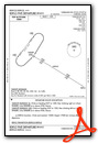
Standard Terminal Arrival (STAR) Charts


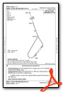
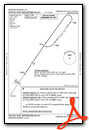
Instrument Approach Procedure (IAP) Charts


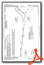
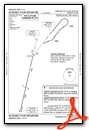
Departure Procedure (DP) Charts
Nearby Airports with Instrument Procedures
| ID | Name | Heading / Distance | ||
|---|---|---|---|---|
 |
PAEI | Eielson AFB Airport | 114° | 21.4 |
|
PANN | Nenana Municipal Airport | 243° | 35.3 |
|
PAHV | Healy River Airport | 207° | 64.0 |
|
PAML | Manley Hot Springs Airport | 279° | 72.1 |
|
PABI | Allen AAF Airport | 130° | 74.4 |
|
PAWB | Beaver Airport | 006° | 93.8 |
|
PFYU | Fort Yukon Airport | 030° | 124.0 |
Airport Images
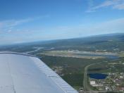
By: skitheo

By: tg


