Login
Register


ANI
Aniak Airport
Official FAA Data Effective 2026-02-19 0901Z
Chart Supplement

VFR Chart of PANI
Sectional Charts at SkyVector.com
IFR Chart of PANI
Enroute Charts at SkyVector.com
Location Information for PANI
Coordinates: N61°34.88' / W159°32.72'Located 00 miles S of Aniak, Alaska on 1722 acres of land. View all Airports in Alaska.
Surveyed Elevation is 96 feet MSL.
Operations Data
|
|
Airport Communications
| AWOS-3P: | 124.3 Tel. 907-675-4282 |
|---|---|
| CTAF: | 122.100 |
| AWOS-3P at KLG (22.7 W): | 119.025 907-471-2434 |
| AWOS-3P at HCA (37.1 N): | 118.325 907-621-7974 |
| AWOS-3PT at CJX (43.7 NE): | 118.4 907-269-2726 |
- APCH/DEP SVC PRVDD BY ANCHORAGE ARTCC ON FREQS 118.15/251.05 (ANIAK RCAG).
- CLEARANCE DELIVERY PRVDD BY ANCHORAGE ARTCC ON FREQ 118.15(ANIAK RCAG).
Nearby Navigation Aids
|
| ||||||||||||||||||

Runway 11/29
| Dimensions: | 6200 x 100 feet / 1890 x 30 meters | |
|---|---|---|
| Surface: | Asphalt / Grooved in Good Condition | |
| Weight Limits: | S-30, D-120, ST-126
PCR VALUE: 405/F/A/X/T
| |
| Edge Lighting: | High Intensity | |
| Runway 11 | Runway 29 | |
| Coordinates: | N61°35.15' / W159°33.63' | N61°34.62' / W159°31.80' |
| Elevation: | 96.8 | 96.7 |
| Traffic Pattern: | Left | Left |
| Runway Heading: | 121° True | 301° True |
| Displaced Threshold: | 400 Feet | 400 Feet |
| Declared Distances: | TORA:5800 TODA:6200 ASDA:5800 LDA:5400 | TORA:5800 TODA:6200 ASDA:5800 LDA:5400 |
| Markings: | Precision Instrument in good condition. | Non-Precision Instrument in good condition. |
| Glide Slope Indicator | P4R (3.00° Glide Path Angle) | P4R (3.00° Glide Path Angle) |
| Approach Lights: | MALSF 1,400 Foot Medium-intensity Approach Lighting System with sequenced flashers. | |
| Obstacles: | 7 ft Road 364 ft from runway, 525 ft left of center | 30 ft Pole 310 ft from runway, 513 ft right of center |
Services Available
| Fuel: | 100LL (blue), Jet-A |
|---|---|
| Transient Storage: | Tiedowns |
| Airframe Repair: | MINOR |
| Engine Repair: | MINOR |
| Bottled Oxygen: | NOT AVAILABLE |
| Bulk Oxygen: | NOT AVAILABLE |
| Other Services: | CARGO HANDLING SERVICES |
Ownership Information
| Ownership: | Publicly owned | |
|---|---|---|
| Owner: | ALASKA DOT&PF CENTRAL REGION | |
| PO BOX 196900 | ||
| ANCHORAGE, AK 99519-6900 | ||
| 907-269-0749 | ||
| Manager: | KEN SMITH | |
| PO BOX 196900, ANIAK AIRPORT | ||
| ANCHORAGE, AK 99519 | ||
| 907-676-0505 | ||
Other Remarks
- LOCK WHEEL TURNS NA ALL SFCS.
- FUEL TRUCK ACES AVBL SLOUGH BEACH E OF RAMP.
- ARPT SAND LRGR GRADATION THAN FAA RCMDD/SEE AC150/5200-30.
- PAEW ON THE RWY.
- TSNT PRKG AVBL, MRKD WITH GREEN CONES.
- WX CAMERA AVBL ON INTERNET AT HTTPS://WEATHERCAMS.FAA.GOV/.
- COLD TEMPERATURE AIRPORT. ALTITUDE CORRECTION REQUIRED AT OR BELOW -37C.
- 0LL FUEL AVBL - CTAF OR 907-675-4295.
- ACTVT MALSF RWY 11; PAPI RWY 11 & 29; HIRL RWY 11/29 - CTAF.
Weather Minimums

Instrument Approach Procedure (IAP) Charts

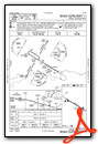

Nearby Airports with Instrument Procedures
| ID | Name | Heading / Distance | ||
|---|---|---|---|---|
 |
PACH | Chuathbaluk Airport | 090° | 9.5 |
|
PALG | Kalskag Airport | 263° | 23.1 |
|
PAHC | Holy Cross Airport | 349° | 37.1 |
|
PACJ | Crooked Creek Airport | 065° | 43.8 |
|
PARS | Russian Mission Airport | 283° | 52.0 |
|
PFAK | Akiak Airport | 230° | 63.7 |
|
PANV | Anvik Airport | 344° | 66.7 |
|
PAHX | Shageluk Airport | 359° | 66.9 |
|
PASL | Sleetmute Airport | 082° | 68.5 |
|
PADM | Marshall Don Hunter Sr Airport | 284° | 72.8 |
|
PFKW | Kwethluk Airport | 230° | 72.8 |
|
PAGX | Grayling Airport | 349° | 80.2 |
Airport Images
Do you have a recent image of this airport? Upload it here!


