Login
Register


ANV
Anvik Airport
Official FAA Data Effective 2026-02-19 0901Z
Chart Supplement

VFR Chart of PANV
Sectional Charts at SkyVector.com
IFR Chart of PANV
Enroute Charts at SkyVector.com
Location Information for PANV
Coordinates: N62°38.84' / W160°11.40'Located 01 miles SE of Anvik, Alaska on 245 acres of land. View all Airports in Alaska.
Surveyed Elevation is 297 feet MSL.
Operations Data
|
|
Airport Communications
| AWOS-3P: | 133.55 Tel. 907-663-6353 |
|---|---|
| UNICOM: | 122.700 |
| CTAF: | 122.700 |
| AWOS-3P at SHX (17.4 E): | 121.575 907-868-7346 |
| AWOS-3P at HCA (29.8 SE): | 118.325 907-621-7974 |
| AWOS-3P at RSH (61.2 SW): | 118.375 907-560-7678 |
- APCH/DEP SVC PRVDD BY ANCHORAGE ARTCC ON FREQS 135.7/335.5 (UNALAKLEET RCAG).
- COMMUNICATIONS PRVDD BY KENAI FSS ON FREQ 122.4 (ANVIK RCO).
Nearby Navigation Aids
|
| ||||||||||||||||||

Runway 17/35
| Dimensions: | 4000 x 75 feet / 1219 x 23 meters | |
|---|---|---|
| Surface: | Gravel in Good Condition | |
| Edge Lighting: | Medium Intensity | |
| Runway 17 | Runway 35 | |
| Coordinates: | N62°39.17' / W160°11.32' | N62°38.51' / W160°11.48' |
| Elevation: | 290.4 | 297.3 |
| Traffic Pattern: | Left | Left |
| Runway Heading: | 186° True | 6° True |
| Glide Slope Indicator | P4L (3.00° Glide Path Angle) | P4L (3.00° Glide Path Angle) |
| REIL: | Yes | Yes |
| Obstacles: | 7 ft Brush 0 ft from runway, 135 ft right of center | 10 ft Brush 0 ft from runway, 245 ft left of center |
Ownership Information
| Ownership: | Publicly owned | |
|---|---|---|
| Owner: | ALASKA DOT&PF NORTHERN REGION | |
| 2301 PEGER ROAD | ||
| FAIRBANKS, AK 99709 | ||
| 907-451-2200 | ||
| Manager: | ERIK WEINGARTH | |
| BOX 135 | ||
| ST MARY'S, AK 99658 | ||
| 907-438-2416 | ||
Other Remarks
- RY COND NOT MONITORED; RCMD VISUAL INSPECTION PRIOR TO LNDG.
- WX CAMERA AVBL ON INTERNET AT HTTPS://WEATHERCAMS.FAA.GOV
- RADIO AIDS TO NAVIGATION - NDB/DME OTS INDEF
- ACTVT MIRL RY 17/35, PAPIS RWY 17 &35, REILS RWY 17& 35 --122.7.
Weather Minimums

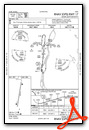
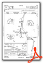
Instrument Approach Procedure (IAP) Charts
Nearby Airports with Instrument Procedures
| ID | Name | Heading / Distance | ||
|---|---|---|---|---|
 |
PAGX | Grayling Airport | 012° | 15.1 |
|
PAHX | Shageluk Airport | 080° | 17.4 |
|
PAHC | Holy Cross Airport | 157° | 30.0 |
|
PARS | Russian Mission Airport | 211° | 61.3 |
|
PANI | Aniak Airport | 163° | 66.7 |
|
PALG | Kalskag Airport | 183° | 67.0 |
|
PADM | Marshall Don Hunter Sr Airport | 228° | 69.8 |
|
PACH | Chuathbaluk Airport | 156° | 69.9 |
|
PAMK | St Michael Airport | 314° | 72.9 |
|
PACJ | Crooked Creek Airport | 128° | 74.1 |
|
PAUN | Unalakleet Airport | 347° | 76.5 |
|
PFSH | Shaktoolik Airport | 345° | 107.4 |
Airport Images
Do you have a recent image of this airport? Upload it here!


