Login
Register


APN
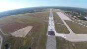
Alpena County Regional Airport
Official FAA Data Effective 2026-01-22 0901Z
Chart Supplement

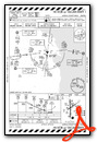
KAPN Airport Diagram

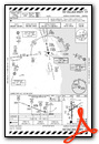
VFR Chart of KAPN
Sectional Charts at SkyVector.com
IFR Chart of KAPN
Enroute Charts at SkyVector.com
Location Information for KAPN
Coordinates: N45°4.68' / W83°33.62'Located 06 miles W of Alpena, Michigan on 3084 acres of land. View all Airports in Michigan.
Surveyed Elevation is 689 feet MSL.
Operations Data
|
|
Airport Communications
| ATIS: | 120.675 327.05 |
|---|---|
| ASOS: | 120.675 Tel. 989-200-3256 |
| ALPENA TOWER: | 121.35 318.1 |
| ALPENA GROUND: | 121.9 275.8 |
| ALPENA APPROACH: | 128.425 379.3 |
| ALPENA DEPARTURE: | 128.425 379.3 |
| UNICOM: | 122.950 |
| PTD: | 348.4 |
| CTAF: | 121.350 |
| EMERG: | 121.5 243.0 |
| AWOS-3 at PZQ (22.5 NW): | 118.125 989-734-7419 |
| AWOS-3P at OSC (38.2 S): | 118.7 989-739-1310 |
| ASOS at GLR (48.7 W): | 118.375 989-732-1571 |
- APCH/DEP SVC PRVDD BY MINNEAPOLIS ARTCC ON FREQS 125.475/269.45 (ALPENA RCAG) WHEN ALPENA APCH CTL CLSD.
- OPR 1300-2100Z++. 348.4
Nearby Navigation Aids
|
| ||||||||||||||||||||||||||||||||||||||||||||||||||||||||||||


Runway 01/19
| Dimensions: | 9001 x 150 feet / 2744 x 46 meters | |
|---|---|---|
| Surface: | Concrete / Grooved in Good Condition | |
| Weight Limits: | S-95, D-115, ST-170, DT-468
TRT 560.
PCR VALUE: 480/F/C/X/T
| |
| Edge Lighting: | High Intensity | |
| Runway 01 | Runway 19 | |
| Coordinates: | N45°3.90' / W83°33.68' | N45°5.38' / W83°33.69' |
| Elevation: | 682.9 | 683.0 |
| Traffic Pattern: | Left | Left |
| Runway Heading: | 360° True | 180° True |
| Declared Distances: | TORA:9001 TODA:9001 ASDA:9001 LDA:9001 | TORA:9001 TODA:9001 ASDA:9001 LDA:9001 |
| Markings: | Precision Instrument in good condition. | Precision Instrument in good condition. |
| Glide Slope Indicator | P4L (3.00° Glide Path Angle) | P4L (3.00° Glide Path Angle) |
| Approach Lights: | MALSR 1,400 Foot Medium-intensity Approach Lighting System with runway alignment indicator lights. | |
| REIL: | Yes | |
| Obstacles: | 68 ft Tree 3190 ft from runway, 329 ft right of center | 56 ft Tree 2174 ft from runway, 440 ft right of center |
Runway 07/25
RWY 07/25 NOT AVBL FOR PART 121/PART 380 OPS WITH SKED PAX CARRYING OPS MORE THAN 9 PAX SEATS AND NON-SKED PAX CARRYING OPS MORE THAN 30 PAX SEATS. | ||
| Dimensions: | 5028 x 100 feet / 1533 x 30 meters | |
|---|---|---|
| Surface: | Concrete / Grooved in Fair Condition | |
| Weight Limits: | 4 /R/B/Z/U, S-93, D-111, ST-170, DT-438
TRT 560.
| |
| Edge Lighting: | Medium Intensity | |
| Runway 07 | Runway 25 | |
| Coordinates: | N45°4.56' / W83°34.00' | N45°4.98' / W83°32.99' |
| Elevation: | 689.5 | 679.6 |
| Traffic Pattern: | Left | Left |
| Runway Heading: | 60° True | 240° True |
| Declared Distances: | TORA:5028 TODA:5028 ASDA:5028 LDA:5028 | TORA:5028 TODA:5028 ASDA:5028 LDA:5028 |
| Markings: | Non-Precision Instrument in good condition. | Non-Precision Instrument in good condition. |
| Glide Slope Indicator | P4L (3.00° Glide Path Angle) | P4L (3.00° Glide Path Angle) |
| REIL: | Yes | Yes |
| Obstacles: | 46 ft Trees 1200 ft from runway | 80 ft Trees 2866 ft from runway, 427 ft left of center |
Services Available
| Fuel: | 100LL (blue), Jet-A |
|---|---|
| Transient Storage: | Hangars,Tiedowns |
| Airframe Repair: | MINOR |
| Engine Repair: | MINOR |
| Bottled Oxygen: | NONE |
| Bulk Oxygen: | NONE |
| Other Services: | CARGO HANDLING SERVICES,CHARTER SERVICE,PILOT INSTRUCTION,AIRCRAFT SALES |
Ownership Information
| Ownership: | Publicly owned | |
|---|---|---|
| Owner: | COUNTY OF ALPENA | |
| 1617 AIRPORT RD | ||
| ALPENA, MI 49707-8213 | ||
| 989-354-2907 | ||
| Manager: | MR. EDWARD HIGGINS | |
| 1617 AIRPORT RD | ||
| ALPENA, MI 49707-8213 | ||
| 989-354-2907 | ||
Other Remarks
- RWY 01 & 19 EACH HAVE 1000 FT OVRN.
- TWY A WEST OF TWY C & TWY B RSTRD TO MIL ONLY. BE ALERT FOR UNCONTROLLED VEHICLES ON THE TWY.
- TWY H EAST OF RWY 01/19 UNLGTD.
- MILITARY: ANG: JOAP SER UNAVBL.
- FOR CD IF UNA TO CTC ON FSS FREQ, CTC MINNEAPOLIS ARTCC AT 651-463-5588.
- BIRDS & OTR WILDLIFE ON & INVOF ARPT.
- MILITARY: SER: FUEL A++.
- MILITARY: ANG: DUTY HRS 0800-1600 MON-FRI EXC HOLS.
- ACTVT MALSR RWY 01; REIL RWY 19, 07, & 25; HIRL RWY 01/19; MIRL RWY 07/25 - CTAF.
- BAK-14 BAK-12A(B) (1500 FT).
- BAK-14 BAK-12A(B) (1515 FT).
Weather Minimums

Instrument Approach Procedure (IAP) Charts


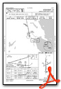
Nearby Airports with Instrument Procedures
| ID | Name | Heading / Distance | ||
|---|---|---|---|---|
 |
KPZQ | Presque Isle County Airport | 331° | 22.5 |
|
KOSC | Oscoda/Wurtsmith Airport | 169° | 38.3 |
|
6D9 | Iosco County Airport | 172° | 46.3 |
|
KGLR | Gaylord Regional Airport | 265° | 48.8 |
|
KSLH | Cheboygan County Airport | 310° | 53.3 |
|
KGOV | Grayling AAF Airport | 244° | 55.3 |
|
KDRM | Drummond Island Airport | 352° | 56.4 |
|
Y31 | West Branch Community Airport | 208° | 56.6 |
|
6Y1 | Bois Blanc Island Airport | 316° | 57.4 |
|
KBFA | Boyne Mountain Airport | 275° | 58.2 |
|
KPLN | Pellston Regional/Emmet County Airport | 299° | 60.1 |
|
KMGN | Harbor Springs Airport | 290° | 61.0 |