Login
Register


PZQ
Presque Isle County Airport
Official FAA Data Effective 2026-01-22 0901Z
Chart Supplement

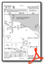
VFR Chart of KPZQ
Sectional Charts at SkyVector.com
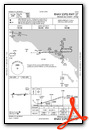
IFR Chart of KPZQ
Enroute Charts at SkyVector.com
Location Information for KPZQ
Coordinates: N45°24.42' / W83°48.77'Located 01 miles S of Rogers City, Michigan on 80 acres of land. View all Airports in Michigan.
Surveyed Elevation is 670 feet MSL.
Operations Data
|
|
Airport Communications
| AWOS-3: | 118.125 Tel. 989-734-7419 |
|---|---|
| ALPENA APPROACH: | 128.425 379.3 |
| ALPENA DEPARTURE: | 128.425 379.3 |
| CTAF: | 122.900 |
| ASOS at APN (22.5 SE): | 120.675 989-200-3256 |
| ATIS at APN (22.5 SE): | 327.05 |
| AWOS-3 at SLH (33.2 NW): | 118.175 231-627-4671 |
- APCH/DEP SVC PRVDD BY MINNEAPOLIS ARTCC (ZMP) ON FREQS 125.475/269.45 (ALPENA RCAG) WHEN ALPENA APCH CTL CLSD.
Nearby Navigation Aids
|
| ||||||||||||||||||||||||||||||||||||||||||||||||||||||||||||


Runway 09/27
| Dimensions: | 4106 x 75 feet / 1252 x 23 meters | |
|---|---|---|
| Surface: | Asphalt in Excellent Condition | |
| Weight Limits: | S-22 | |
| Edge Lighting: | Medium Intensity | |
| Runway 09 | Runway 27 | |
| Coordinates: | N45°24.42' / W83°49.25' | N45°24.44' / W83°48.29' |
| Elevation: | 668.8 | 670.2 |
| Traffic Pattern: | Left | Left |
| Runway Heading: | 88° True | 268° True |
| Displaced Threshold: | 220 Feet | 379 Feet |
| Markings: | Non-Precision Instrument in good condition. | Non-Precision Instrument in good condition. |
| Glide Slope Indicator | P4L (3.00° Glide Path Angle) PAPI UNUSBL BYD 9 DEGS LEFT OR RIGHT OF CNTRLN. | P4L (3.00° Glide Path Angle) |
| REIL: | Yes | Yes |
| Obstacles: | 8 ft Fence 200 ft from runway, 250 ft right of center APCH RATIO 20:1 TO DTHR. |
12 ft Sign 299 ft from runway, 193 ft left of center APCH RATIO 20:1 TO DTHR OVR +42 FT MKD/LGTD PLINES, 1040 DIST. |
Services Available
| Fuel: | 100LL (blue) |
|---|---|
| Transient Storage: | Hangars,Tiedowns |
| Airframe Repair: | NONE |
| Engine Repair: | NONE |
| Bottled Oxygen: | NONE |
| Bulk Oxygen: | NONE |
Ownership Information
| Ownership: | Publicly owned | |
|---|---|---|
| Owner: | PRESQUE ISLE COUNTY | |
| 658 S BRADLEY HWY | ||
| ROGERS CITY, MI 49779-9552 | ||
| 989-734-3288 | ||
| Manager: | ALAN STILLER | |
| 151 E HURON AVE, PO BOX 110 | ||
| ROGERS CITY, MI 49779-0110 | ||
| 906-430-7718 | AFT HRS CELL. | |
Other Remarks
- DEER, BIRDS, & WILDLIFE ON & INVOF ARPT.
- CALL AMGR TO VFY SNOW REMOVAL & WINTER CONDS.
- TRML BLDG ACES: PRESS 5-3-2-1.
- FOR CD CTC MINNEAPOLIS ARTCC AT 651-463-5588.
- 0LL FUEL AVBL O/R CALL AMGR.
- ACTVT REIL RWY 09 & 27; PAPI RWY 09 & 27; MIRL RWY 09/27 - CTAF.
Weather Minimums

Instrument Approach Procedure (IAP) Charts
Nearby Airports with Instrument Procedures
| ID | Name | Heading / Distance | ||
|---|---|---|---|---|
 |
KAPN | Alpena County Regional Airport | 151° | 22.5 |
|
KSLH | Cheboygan County Airport | 296° | 33.3 |
|
6Y1 | Bois Blanc Island Airport | 306° | 36.2 |
|
KDRM | Drummond Island Airport | 004° | 36.3 |
|
KPLN | Pellston Regional/Emmet County Airport | 283° | 42.7 |
|
KMCD | Mackinac Island Airport | 308° | 44.3 |
|
KGLR | Gaylord Regional Airport | 238° | 44.6 |
|
KMGN | Harbor Springs Airport | 271° | 46.5 |
|
83D | Mackinac County Airport | 307° | 48.6 |
|
KBFA | Boyne Mountain Airport | 253° | 49.2 |
|
N98 | Boyne City Municipal Airport | 256° | 51.2 |
|
KCIU | Chippewa County International Airport | 331° | 57.7 |
Airport Images
Do you have a recent image of this airport? Upload it here!


