Login
Register


AUN
Auburn Municipal Airport
Official FAA Data Effective 2026-02-19 0901Z
Chart Supplement

VFR Chart of KAUN
Sectional Charts at SkyVector.com
IFR Chart of KAUN
Enroute Charts at SkyVector.com
Location Information for KAUN
Coordinates: N38°57.29' / W121°4.90'Located 03 miles N of Auburn, California on 254 acres of land. View all Airports in California.
Surveyed Elevation is 1538 feet MSL.
HEL TFC PAT 580 FT AGL.
Operations Data
|
|
Airport Communications
| AWOS-3: | 119.375 Tel. 530-888-8934 |
|---|---|
| NORCAL APPROACH: | 125.4 317.5 |
| NORCAL DEPARTURE: | 125.4 317.5 |
| UNICOM: | 122.700 |
| CTAF: | 122.700 |
| AWOS-3 at LHM (12.8 W): | 124.25 916-645-0698 |
| AWOS-3 at GOO (16.5 N): | 121.325 530-273-0029 |
| AWOS-3P at O61 (16.9 S): | 120.0 530-677-5392 |
Nearby Navigation Aids
|
| ||||||||||||||||||||||||||||||||||||


Runway 07/25
| Dimensions: | 3700 x 75 feet / 1128 x 23 meters | |
|---|---|---|
| Surface: | Asphalt in Good Condition | |
| Weight Limits: | S-30 | |
| Edge Lighting: | Medium Intensity | |
| Runway 07 | Runway 25 | |
| Coordinates: | N38°57.26' / W121°5.29' | N38°57.32' / W121°4.52' |
| Elevation: | 1492.7 | 1538.2 |
| Traffic Pattern: | Left HEL RIGHT TFC FOR RWY 07. |
Left |
| Runway Heading: | 84° True | 264° True |
| Displaced Threshold: | 200 Feet | |
| Markings: | Non-Precision Instrument in good condition. | Non-Precision Instrument in good condition. |
| Glide Slope Indicator | P2L (3.00° Glide Path Angle) | P2L (3.50° Glide Path Angle) PAPI UNUSBL BYD 5 DEG LEFT OF CNTRLN |
| Obstacles: | 4 ft Hill 342 ft from runway | 10 ft Hill 425 ft from runway, 90 ft left of center |
Services Available
| Fuel: | 100LL (blue), Jet-A, Jet A-1 |
|---|---|
| Transient Storage: | Hangars,Tiedowns |
| Airframe Repair: | MAJOR |
| Engine Repair: | MAJOR |
| Bottled Oxygen: | HIGH/LOW |
| Bulk Oxygen: | HIGH/LOW |
| Other Services: | AVIONICS,CHARTER SERVICE,PILOT INSTRUCTION,AIRCRAFT RENTAL |
Ownership Information
| Ownership: | Publicly owned | |
|---|---|---|
| Owner: | CITY OF AUBURN | |
| 1225 LINCOLN WAY | ||
| AUBURN, CA 95603 | ||
| 530-823-4211 | ||
| Manager: | TYGHE RICHARDSON | |
| 1225 LINCOLN WAY | ||
| AUBURN, CA 95603 | ||
| 530-888-8174 | ||
Other Remarks
- FUEL 100LL & JET A AVAILABLE 24 HRS.
- NOISE: VFR NOISE ABATEMENT PROCS: RWY 25 NO STRAIGHT OUT VFR DEP. AT END OF RWY TRACK 230 DEG OVER SELF-STORAGE FAC TO AVOID NOISE SENSITIVE AREAS. TURN ON CRS AFTER REACHING 2500 MSL. RWY 07 TURN ON CRS AFTER REACHING 2500 MSL. AVOID NOISE SENSITIVE AREAS. SEE NOISE ABATEMENT BROCHURE.
- TSNT PRKG T'S ARE PAINTED BLUE.
- ULTRALIGHT ACTIVITY ON AND INVOF ARPT.
- FOR CD CTC NORCAL APCH AT 916-361-6874.
- NOISE ABATEMENT ALL DEPS MIN PWR WHILE OBSG SAFE ACFT OPS.
- ACTVT MIRL RWY 07/25 - CTAF. PAPI RWY 7 & RWY 25 OPER CONSLY.
- HEL TFC PAT 580 FT AGL.
Weather Minimums

Instrument Approach Procedure (IAP) Charts
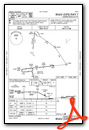
Departure Procedure Obstacles (DPO) Charts

Nearby Airports with Instrument Procedures
| ID | Name | Heading / Distance | ||
|---|---|---|---|---|
 |
KLHM | Lincoln Regional/Karl Harder Field Airport | 257° | 12.9 |
|
KGOO | Nevada County Airport | 012° | 16.6 |
|
KBAB | Beale AFB Airport | 303° | 19.8 |
|
KPVF | Placerville Airport | 131° | 20.7 |
|
KMCC | Mc Clellan Airfield Airport | 221° | 22.8 |
|
KMYV | Yuba County Airport | 290° | 24.4 |
|
KMHR | Sacramento Mather Airport | 202° | 26.0 |
|
KSMF | Sacramento International Airport | 237° | 28.5 |
|
KSAC | Sacramento Exec Airport | 216° | 32.8 |
|
KJAQ | Westover Field Amador County Airport | 158° | 37.2 |
|
O41 | Watts-Woodland Airport | 245° | 40.7 |
|
KOVE | Oroville Municipal Airport | 321° | 40.7 |


Airport Images

By: pgvardara@icloud.com

By: Alexsipilot
- 1 of 2
- next ›


