Login
Register


O41
Watts-Woodland Airport
Official FAA Data Effective 2026-02-19 0901Z
Chart Supplement

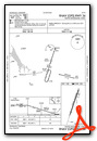
VFR Chart of O41
Sectional Charts at SkyVector.com
IFR Chart of O41
Enroute Charts at SkyVector.com
Location Information for O41
Coordinates: N38°40.43' / W121°52.32'Located 04 miles W of Woodland, California on 100 acres of land. View all Airports in California.
Surveyed Elevation is 125 feet MSL.
TPA FOR TURBINE ACFT 1500 FT AGL; TPA FOR OTHER ACFT 1000 FT AGL.
Operations Data
|
|
Airport Communications
| TRAVIS APPROACH: | 126.6 281.45 |
|---|---|
| TRAVIS DEPARTURE: | 126.6 281.45 |
| CTAF: | 122.800 |
| UNICOM: | 122.800 |
| AWOS-3P at DWA (5.7 S): | 125.775 530-750-2759 |
| AWOS-3 at EDU (9.5 SE): | 119.025 530-754-6839 |
| ASOS at SMF (13.0 E): | 916-649-3996 |
Nearby Navigation Aids
|
| ||||||||||||||||||||||||||||||||||||


Runway 18/36
| Dimensions: | 3759 x 60 feet / 1146 x 18 meters | |
|---|---|---|
| Surface: | Asphalt in Fair Condition | |
| Weight Limits: | S-12
GROSS PAVEMENT STRENGTH PRVDD BY MGR; 12000 LBS.
| |
| Edge Lighting: | Medium Intensity | |
| Runway 18 | Runway 36 | |
| Coordinates: | N38°40.72' / W121°52.20' | N38°40.14' / W121°52.46' |
| Elevation: | 107.0 | 124.0 |
| Runway Heading: | 199° True | 19° True |
| Displaced Threshold: | 630 Feet | 385 Feet |
| Declared Distances: | TORA:3759 TODA:3759 ASDA:3559 LDA:2929 | TORA:3759 TODA:3759 ASDA:3629 LDA:3244 |
| Markings: | Basic in poor condition. | Basic in poor condition. |
| Obstacles: | 36 ft Trees 600 ft from runway, 209 ft right of center RWY 18 APCH RATIO 34:1 TO DSPLCD THLD. +15 FT ROAD 125 FT FM EOR AND +20 FT BUSHES AND TREE 100 FT RIGHT 75 FT FM EOR. |
20 ft Antenna 300 ft from runway, 100 ft right of center RY 36 APCH RATIO 34:1 TO DSPLCD THLD. RWY 36 +4' FENCE 55' & ROAD 80' FROM THR. |
Services Available
| Fuel: | 100LL (blue) |
|---|---|
| Transient Storage: | Hangars,Tiedowns |
| Airframe Repair: | MAJOR |
| Engine Repair: | MAJOR |
| Bottled Oxygen: | HIGH/LOW |
| Bulk Oxygen: | NONE |
| Other Services: | PILOT INSTRUCTION,AIRCRAFT RENTAL,AIRCRAFT SALES |
Ownership Information
| Ownership: | Privately Owned | |
|---|---|---|
| Owner: | WATTS-WOODLAND AIRPORT INC. | |
| 17992 COUNTY ROAD 94B | ||
| WOODLAND, CA 95695 | ||
| 530-867-6652 | ||
| Manager: | MILTON B. WATTS | |
| 17992 COUNTY ROAD 94B | ||
| WOODLAND, CA 95695 | ||
| 530-867-6652 | ||
Other Remarks
- THIS AIRPORT HAS BEEN SURVEYED BY THE NATIONAL GEODETIC SURVEY.
- TWIN ENGINE ACFT BACK TAXI ON RY.
- RY 18 UNLGTD 60 FT TREES HIGHER THAN POLE MOUNTED OBSTN LGTS.
- FOR CD CTC OAKLAND ARTCC AT 510-745-3380.
- SVRLY FADED RWY MRKGS.
- SVRLY FADED RWY MRKGS.
- 0LL FUEL 24 HRS WITH CREDIT CARD.
- ACTVT MIRL RY 18/36 - CTAF.
- TPA FOR TURBINE ACFT 1500 FT AGL; TPA FOR OTHER ACFT 1000 FT AGL.
Weather Minimums
Instrument Approach Procedure (IAP) Charts
Nearby Airports with Instrument Procedures
| ID | Name | Heading / Distance | ||
|---|---|---|---|---|
 |
KDWA | Yolo County Airport | 172° | 5.7 |
|
KEDU | University Airport | 154° | 9.4 |
|
KSMF | Sacramento International Airport | 084° | 13.3 |
|
KVCB | Nut Tree Airport | 193° | 18.2 |
|
KSAC | Sacramento Exec Airport | 118° | 20.3 |
|
KMCC | Mc Clellan Airfield Airport | 090° | 22.2 |
|
KSUU | Travis AFB Airport | 185° | 24.7 |
|
KMHR | Sacramento Mather Airport | 104° | 28.0 |
|
KLHM | Lincoln Regional/Karl Harder Field Airport | 059° | 28.2 |
|
KMYV | Yuba County Airport | 029° | 29.1 |
|
O88 | Rio Vista Municipal Airport | 164° | 29.9 |
|
O08 | Colusa County Airport | 349° | 30.8 |
Airport Images

By: gyrosteve


