Login
Register
BIH
Bishop Airport
Official FAA Data Effective 2026-02-19 0901Z
VFR Chart of KBIH
Sectional Charts at SkyVector.com
IFR Chart of KBIH
Enroute Charts at SkyVector.com
Location Information for KBIH
Coordinates: N37°22.39' / W118°21.82'Located 02 miles E of Bishop, California on 830 acres of land. View all Airports in California.
Surveyed Elevation is 4124 feet MSL.
Operations Data
|
|
Airport Communications
| ASOS: | 119.025 Tel. 760-227-6035 |
|---|---|
| UNICOM: | 123.000 |
| CTAF: | 123.000 |
| AWOS-3PT at MMH (27.3 NW): | 118.05 760-934-6020 |
| AWOS-3 at O26 (49.4 S): | 118.25 760-876-4014 |
| AWOS-3PT at O32 (67.1 SW): | 120.175 559-637-9453 |
- COMMUNICATIONS PRVDD BY RIVERSIDE RADIO ON FREQ 122.6 (BISHOP RCO).
- APCH/DEP CTL SVC PRVDD BY OAKLAND ARTCC (ZOA) ON FREQS 125.75/284.65 (BISHOP RCAG).
Nearby Navigation Aids
|
| ||||||||||||||||||||||||||||||||||||
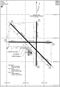
Runway 12/30
| Dimensions: | 7498 x 100 feet / 2285 x 30 meters PVD SHOULDER 10' TO LGTS PLUS 15' TO EDGE. | |
|---|---|---|
| Surface: | Asphalt / Porous Friction Course in Excellent Condition | |
| Weight Limits: | S-120, D-235, ST-400
PCR VALUE: 590/F/B/X/T
| |
| Edge Lighting: | Medium Intensity | |
| Runway 12 | Runway 30 | |
| Coordinates: | N37°22.81' / W118°22.40' | N37°21.93' / W118°21.32' |
| Elevation: | 4122.6 | 4100.0 |
| Traffic Pattern: | Left | Left |
| Runway Heading: | 135° True | 315° True |
| Declared Distances: | TORA:7498 TODA:7498 ASDA:7098 LDA:7098 | TORA:7498 TODA:7498 ASDA:6743 LDA:6743 |
| Markings: | Non-Precision Instrument in good condition. | Non-Precision Instrument in good condition. |
| Glide Slope Indicator | P4L (3.00° Glide Path Angle) | P4L (3.52° Glide Path Angle) PAPI UNUSBL BYD 4 NM. |
| REIL: | Yes | Yes |
| Obstacles: | 35 ft Power Line 1555 ft from runway, 175 ft left of center | |
Runway 17/35
| Dimensions: | 5600 x 100 feet / 1707 x 30 meters PVD SHOULDER 10' TO LGTS PLUS 15' TO EDGE. | |
|---|---|---|
| Surface: | Asphalt / Porous Friction Course in Good Condition | |
| Weight Limits: | 49 /F/B/W/T, S-100, D-140, ST-240 | |
| Edge Lighting: | Medium Intensity | |
| Runway 17 | Runway 35 | |
| Coordinates: | N37°22.84' / W118°21.70' | N37°21.92' / W118°21.71' |
| Elevation: | 4112.5 | 4104.9 |
| Traffic Pattern: | Left | Left |
| Runway Heading: | 180° True | 0 |
| Markings: | Non-Precision Instrument in good condition. | Non-Precision Instrument in good condition. |
| Glide Slope Indicator | P4L (3.50° Glide Path Angle) PAPI UNUSBL BYD 5 NM. | P4L (3.00° Glide Path Angle) PAPI UNUSBL BYD 5 NM. |
| REIL: | Yes | Yes |
| Obstacles: | 30 ft Trees 1442 ft from runway | |
Runway 08/26
| Dimensions: | 5567 x 100 feet / 1697 x 30 meters | |
|---|---|---|
| Surface: | Asphalt in Fair Condition | |
| Weight Limits: | 25 /F/A/W/T, S-40, D-56, ST-98 | |
| Edge Lighting: | Medium Intensity | |
| Runway 08 | Runway 26 | |
| Coordinates: | N37°22.42' / W118°22.45' | N37°22.41' / W118°21.30' |
| Elevation: | 4124.1 | 4100.3 |
| Traffic Pattern: | Left | Left |
| Runway Heading: | 90° True | 270° True |
| Markings: | Non-Precision Instrument in good condition. | Non-Precision Instrument in good condition. |
| Glide Slope Indicator | P2L (3.50° Glide Path Angle) PAPI UNUSBL BYD 5 NM. | P2L (3.00° Glide Path Angle) PAPI UNUSBL BYD 2 NM. |
| Obstacles: | 47 ft Trees 1350 ft from runway, 130 ft left of center | 10' DEEP DITCH 100' FROM THR. |
Helipad H2
| Dimensions: | 100 x 100 feet / 30 x 30 meters | |
|---|---|---|
| Surface: | Asphalt in Fair Condition | |
| Coordinates: | N37°22.29' / W118°22.49' | N0°0.00' / E0°0.00' |
| Elevation: | 4124.0 | |
Helipad H1
| Dimensions: | 40 x 40 feet / 12 x 12 meters | |
|---|---|---|
| Surface: | Asphalt in Fair Condition | |
| Coordinates: | N37°22.36' / W118°22.05' | N0°0.00' / E0°0.00' |
| Elevation: | 4124.0 | |
Services Available
| Fuel: | 100LL (blue), Jet-A |
|---|---|
| Transient Storage: | Tiedowns |
| Airframe Repair: | NONE |
| Engine Repair: | NONE |
| Bottled Oxygen: | NOT AVAILABLE |
| Bulk Oxygen: | NONE |
| Other Services: | AIR AMBULANCE SERVICES,PILOT INSTRUCTION HTTPS://BISHOPFLYING.CLUB/ |
Ownership Information
| Ownership: | Publicly owned | |
|---|---|---|
| Owner: | INYO COUNTY | LEASED, CONSTRUCTED AND MAINTAINED BY INYO COUNTY. CITY OF LOS ANGELES IS UNDERLYING LAND OWNER - 300 MANDICH ST, BISHOP CA 93514 |
| 168 N EDWARDS, PO DRAWER Q | ||
| INDEPENDENCE, CA 93526 | ||
| 760-878-0201 | ||
| Manager: | ASHLEY HELMS | ASHLEY HELMS, DEPUTY PUBLIC WORKS DIRECTOR - AIRPORTS; AHELMS@INYOCOUNTY.US. |
| 703 AIRPORT ROAD | ||
| BISHOP, CA 93514 | ||
| (760) 872-2971 | ||
Other Remarks
- MAIN RAMP IS RSTRD TO PART 121; OTRS USE TSNT RAMP BY FUEL FARM.
- NO INTXN DEPS; HEL TFC APCH ARPT FM THE WEST BOUNDARY.
- RAMP FEES FOR COMM ACFT; MAY BE OFFSET WITH FUEL PURCHASE.
- OVNGT TIE-DOWN FEE; ONE NIGHT MAY BE OFFSET WITH MIN FUEL PURCHASE.
- FUEL DISCOUNTS FOR VOLUME PURCHASES.
- NO LOCAL TAXI SERVICE; DIAL-A-RIDE AVBL, BUT LTD ON SUN.
- FOR CD IF UNA TO CTC ON FSS FREQ, CTC OAKLAND ARTCC AT 510-745-3380.
- ADMIN OFC AT ARPT 760-872-2971. AFTER HRS EMERG: 760-937-4017.
- ACTVT REIL RWY 12, 30, 17, & 35; PAPI RWY 08, 26, 12, 30, 17, & 35; MIRL RWY 08/26, 12/30, & 17/35 - CTAF.
Weather Minimums
Instrument Approach Procedure (IAP) Charts
Nearby Airports with Instrument Procedures
| ID | Name | Heading / Distance | ||
|---|---|---|---|---|
 |
KMMH | Mammoth Yosemite Airport | 303° | 27.2 |
 |
O32 | Reedley Municipal Airport | 231° | 67.1 |
 |
KHTH | Hawthorne Industrial Airport | 349° | 71.4 |
 |
KTPH | Tonopah Airport | 055° | 73.4 |
 |
KFAT | Fresno Yosemite International Airport | 241° | 74.2 |
 |
KTNX | Tonopah Test Range Airport | 070° | 79.7 |
 |
KFCH | Fresno Chandler Exec Airport | 241° | 79.8 |
 |
KMPI | Mariposa-Yosemite Airport | 276° | 80.5 |
 |
KVIS | Visalia Municipal Airport | 218° | 80.3 |
 |
KTLR | Mefford Field Airport | 212° | 86.4 |
 |
KMAE | Madera Municipal Airport | 255° | 87.0 |
 |
KPTV | Porterville Municipal Airport | 202° | 87.3 |


Comments
Great Facility and Place to Visit
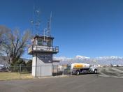
Very good runways and ramp. Nice manned terminal with pilots lounge, bathrooms, and snacks. Aircraft services available. Shuttle to town and hotels. Competive fuel prices. Nice view of the Sierra Nevada Range to the west. The airport is bound by mountains on its east and west sides, so you'll need to climb a bit before heading east or west.