Login
Register


BMT
Beaumont Municipal Airport
Official FAA Data Effective 2026-02-19 0901Z
Chart Supplement

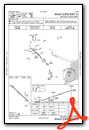
VFR Chart of KBMT
Sectional Charts at SkyVector.com
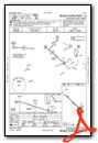
IFR Chart of KBMT
Enroute Charts at SkyVector.com
Location Information for KBMT
Coordinates: N30°4.21' / W94°12.91'Located 06 miles W of Beaumont, Texas on 276 acres of land. View all Airports in Texas.
Surveyed Elevation is 31 feet MSL.
Operations Data
|
|
Airport Communications
| AWOS-3PT: | 118.425 Tel. 409-866-2832 |
|---|---|
| HOUSTON APPROACH: | 121.3 377.1 |
| HOUSTON DEPARTURE: | 121.3 377.1 |
| CLEARANCE DELIVERY: | 121.75 |
| UNICOM: | 123.000 |
| CTAF: | 123.000 |
| ASOS at BPT (12.1 SE): | 126.3 409-223-4011 |
| ATIS at BPT (12.4 SE): | 126.3 |
| AWOS-3 at ORG (21.3 E): | 118.975 409-670-9591 |
Nearby Navigation Aids
|
| ||||||||||||||||||||||||||||||||||||||||||||||||||||||||||||


Runway 13/31
| Dimensions: | 4001 x 75 feet / 1220 x 23 meters | |
|---|---|---|
| Surface: | Asphalt in Excellent Condition | |
| Weight Limits: | S-17 | |
| Edge Lighting: | Medium Intensity | |
| Runway 13 | Runway 31 | |
| Coordinates: | N30°4.46' / W94°13.23' | N30°4.02' / W94°12.67' |
| Elevation: | 28.8 | 31.4 |
| Traffic Pattern: | Right | Left |
| Runway Heading: | 132° True | 312° True |
| Displaced Threshold: | 332 Feet | 67 Feet |
| Markings: | Non-Precision Instrument in good condition. | Non-Precision Instrument in good condition. |
| Glide Slope Indicator | P4L (3.00° Glide Path Angle) | P4L (4.00° Glide Path Angle) |
| REIL: | Yes | |
| Obstacles: | 45 ft Power Line 745 ft from runway, 300 ft left of center ALSO, 45 FT PLINE, 745 FT DSTC, 300 FT L, 12:1 AT RWY END, 23:1 TO DSPLCD THR. APCH SLOPE 23:1 TO DSPLCD THR. |
15 ft Road 350 ft from runway, 260 ft right of center APCH SLOPE 16:1 TO DSPLCD THR OVR 54 FT TREE, 900 FT DSTC. |
Services Available
| Fuel: | 100LL (blue), Jet-A |
|---|---|
| Transient Storage: | Hangars,Tiedowns |
| Airframe Repair: | MAJOR |
| Engine Repair: | MAJOR |
| Bottled Oxygen: | NOT AVAILABLE |
| Bulk Oxygen: | NONE |
| Other Services: | AIR AMBULANCE SERVICES,PILOT INSTRUCTION,AIRCRAFT RENTAL |
Ownership Information
| Ownership: | Publicly owned | |
|---|---|---|
| Owner: | CITY OF BEAUMONT | |
| PO BOX 3827 | ||
| BEAUMONT, TX 77704 | ||
| 409-880-3725 | ||
| Manager: | CHRIS MEAUX | |
| 455 KEITH RD | ||
| BEAUMONT, TX 77713 | ||
| 409-866-0084 | AMGR CELL 409-679-0222 | |
Other Remarks
- DEER ON AND INVOF ARPT.
- FOR CD CTC HOUSTON APCH AT 281-443-5844. TO CNL IFR CTC HOUSTON APCH AT 281-443-5888.
- 0LL 100LL AVBL 24 HRS SELF SVC.
- DUSK-DAWN. MIRL RWY 13/31 PRESET LOW INTST; TO INCR INTST ACTVT - CTAF.
Weather Minimums

Instrument Approach Procedure (IAP) Charts
Nearby Airports with Instrument Procedures
| ID | Name | Heading / Distance | ||
|---|---|---|---|---|
 |
KBPT | Jack Brooks Regional Airport | 125° | 12.4 |
|
45R | Hawthorne Field Airport | 352° | 16.1 |
|
T90 | Chambers County/Winnie Stowell Airport | 216° | 18.8 |
|
KORG | Orange County Airport | 090° | 21.4 |
|
T78 | Liberty Municipal Airport | 271° | 25.2 |
|
T00 | Chambers County Airport | 232° | 29.5 |
|
54T | Rwj Airpark Airport | 240° | 37.8 |
|
KHPY | Baytown Airport | 246° | 42.0 |
|
KUXL | Southland Field Airport | 084° | 43.8 |
|
5R8 | De Quincy Industrial Airpark Airport | 059° | 44.5 |
|
6R3 | Cleveland Municipal Airport | 292° | 44.6 |
|
KJAS | Jasper County/Bell Field Airport | 010° | 49.7 |
Airport Images
Do you have a recent image of this airport? Upload it here!


