Login
Register


ETH
Wheaton Municipal Airport
Official FAA Data Effective 2026-01-22 0901Z
Chart Supplement

VFR Chart of KETH
Sectional Charts at SkyVector.com
IFR Chart of KETH
Enroute Charts at SkyVector.com
Location Information for KETH
Coordinates: N45°46.83' / W96°32.63'Located 03 miles SW of Wheaton, Minnesota on 110 acres of land. View all Airports in Minnesota.
Surveyed Elevation is 1022 feet MSL.
Operations Data
|
|
Airport Communications
| AWOS-3: | 118.775 Tel. 320-563-4975 |
|---|---|
| UNICOM: | 122.800 |
| CTAF: | 122.800 |
| AWOS-3 at Y63 (26.1 NE): | 118.075 218-685-6456 |
| AWOS-3PT at MOX (27.4 SE): | 118.6 320-589-1303 |
| AWOS-3 at BWP (28.0 N): | 127.875 701-642-9800 |
- APCH/DEP SVC PRVDD BY MINNEAPOLIS ARTCC ON FREQS 126.1/269.2 (ALEXANDRIA RCAG).
Nearby Navigation Aids
|
| ||||||||||||||||||||||||||||||||||||||||||||||||


Runway 16/34
| Dimensions: | 3298 x 75 feet / 1005 x 23 meters | |
|---|---|---|
| Surface: | Asphalt in Fair Condition | |
| Edge Lighting: | Medium Intensity | |
| Runway 16 | Runway 34 | |
| Coordinates: | N45°47.06' / W96°32.67' | N45°46.54' / W96°32.46' |
| Elevation: | 1017.2 | 1022.7 |
| Traffic Pattern: | Left | Left |
| Runway Heading: | 164° True | 344° True |
| Markings: | Non-Precision Instrument in good condition. | Non-Precision Instrument in good condition. |
| Glide Slope Indicator | P2L (3.00° Glide Path Angle) | P2L (3.00° Glide Path Angle) PAPI 34 UNUSABLE BYD 8 DEGREE LEFT OF COURSE. |
Runway 06/24
NOT PLOWED WINTER MONTHS. | ||
| Dimensions: | 1953 x 175 feet / 595 x 53 meters | |
|---|---|---|
| Surface: | Turf in Good Condition | |
| Runway 06 | Runway 24 | |
| Coordinates: | N45°46.81' / W96°32.94' | N45°46.95' / W96°32.53' |
| Elevation: | 1016.0 | 1017.4 |
| Traffic Pattern: | Left | Left |
| Runway Heading: | 63° True | 243° True |
Services Available
| Fuel: | NONE |
|---|---|
| Transient Storage: | Tiedowns |
| Airframe Repair: | NONE |
| Engine Repair: | NONE |
| Bottled Oxygen: | NONE |
| Bulk Oxygen: | NONE |
| Other Services: | CROP DUSTING SERVICES,AIRCRAFT SALES |
Ownership Information
| Ownership: | Publicly owned | |
|---|---|---|
| Owner: | CITY OF WHEATON | |
| PO BOX 868, 104 9TH ST N | ||
| WHEATON, MN 56296 | ||
| 320-563-4110 | ||
| Manager: | AMY OLSON | |
| PO BOX 868, 104 9TH ST N | ||
| WHEATON, MN 56296 | ||
| 320-563-4110 | ||
Other Remarks
- FOR CD CTC MINNEAPOLIS ARTCC AT 651-463-5588.
- MARKED WITH YELLOW CONES.
- RY 16/34 MIRL PRESET TO LOW INTST. TO INCR INTST & ACTVT PAPI RY 16/34 - CTAF.
Weather Minimums


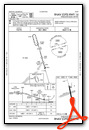
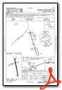
Instrument Approach Procedure (IAP) Charts
Nearby Airports with Instrument Procedures
| ID | Name | Heading / Distance | ||
|---|---|---|---|---|
 |
8D3 | Sisseton Municipal Airport | 250° | 20.0 |
|
Y63 | Elbow Lake Municipal/Pride of The Prairie Airport | 061° | 26.4 |
|
KMOX | Morris Municipal/Charlie Schmidt Field Airport | 117° | 27.6 |
|
KBWP | Harry Stern Airport | 354° | 28.0 |
|
KVVV | Ortonville Municipal/Martinson Field Airport | 169° | 29.0 |
|
1D1 | Milbank Municipal Airport | 181° | 33.0 |
|
KFFM | Fergus Falls Regional Airport | 028° | 34.3 |
|
KAQP | Appleton Municipal Airport | 145° | 40.2 |
|
KBBB | Benson Municipal Airport | 125° | 46.3 |
|
KAXN | Alexandria Regional/Chandler Field Airport | 083° | 48.5 |
|
KDXX | Lac Qui Parle County Airport | 161° | 50.1 |
|
KBTN | Britton Municipal Airport | 272° | 50.4 |
Airport Images
Do you have a recent image of this airport? Upload it here!


