Login
Register


BVY
Beverly Regional Airport
Official FAA Data Effective 2026-02-19 0901Z
Chart Supplement

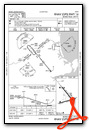
KBVY Airport Diagram

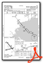
VFR Chart of KBVY
Sectional Charts at SkyVector.com
IFR Chart of KBVY
Enroute Charts at SkyVector.com
Location Information for KBVY
Coordinates: N42°35.05' / W70°54.97'Located 03 miles NW of Beverly, Massachusetts on 470 acres of land. View all Airports in Massachusetts.
Surveyed Elevation is 107 feet MSL.
Operations Data
|
|
Airport Communications
| ATIS: | 119.2 |
|---|---|
| ASOS: | 119.2 Tel. 978-921-5042 |
| BEVERLY TOWER: | 125.2 |
| BEVERLY GROUND: | 121.6 |
| BOSTON APPROACH: | 124.4 279.6 |
| BOSTON DEPARTURE: | 124.4 279.6 |
| DREEM STAR: | 119.0 327.1 124.4 279.6 |
| ZELKA STAR: | 124.4 279.6 |
| CTAF: | 125.200 |
| UNICOM: | 122.950 |
| ASOS at LWM (12.0 NW): | 978-687-8017 |
| ATIS at LWM (12.1 NW): | 126.75 |
| ASOS at BOS (13.3 S): | 135.0 339-746-6855 |
Nearby Navigation Aids
|
| ||||||||||||||||||||||||||||||||||||||||||||||||||||||||||||


Runway 16/34
| Dimensions: | 5001 x 100 feet / 1524 x 30 meters | |
|---|---|---|
| Surface: | Asphalt / Grooved in Excellent Condition | |
| Weight Limits: | S-30, D-55, ST-103
PCR VALUE: 200/F/B/X/T
| |
| Edge Lighting: | Medium Intensity | |
| Runway 16 | Runway 34 | |
| Coordinates: | N42°35.52' / W70°55.32' | N42°34.88' / W70°54.61' |
| Elevation: | 107.2 | 82.1 |
| Traffic Pattern: | Left | Left |
| Runway Heading: | 141° True | 321° True |
| Displaced Threshold: | 240 Feet | |
| Markings: | Non-Precision Instrument in fair condition. | Non-Precision Instrument in fair condition. |
| Glide Slope Indicator | P4L (3.50° Glide Path Angle) | |
| Approach Lights: | MALS 1,400 Foot Medium-intensity Approach Lighting System. NON-STD MALS - 800 FT. | |
| REIL: | Yes | |
| Obstacles: | 32 ft Trees 1000 ft from runway, 125 ft right of center 30:1 TO DTHR. |
|
Runway 09/27
| Dimensions: | 4755 x 100 feet / 1449 x 30 meters | |
|---|---|---|
| Surface: | Asphalt / Grooved in Good Condition | |
| Weight Limits: | S-30, D-114, ST-180
PCR VALUE: 200/F/B/X/T
| |
| Edge Lighting: | Medium Intensity | |
| Runway 09 | Runway 27 | |
| Coordinates: | N42°34.78' / W70°55.49' | N42°35.00' / W70°54.47' |
| Elevation: | 71.5 | 91.2 |
| Traffic Pattern: | Left | Left |
| Runway Heading: | 74° True | 254° True |
| Displaced Threshold: | 250 Feet | |
| Markings: | Non-Precision Instrument in good condition. | Non-Precision Instrument in good condition. |
| Glide Slope Indicator | P4L (3.00° Glide Path Angle) | P4L (3.22° Glide Path Angle) |
| Obstacles: | 15 ft Tree 300 ft from runway, 150 ft left of center | 22 ft Trees 396 ft from runway, 125 ft right of center 50:1 TO DTHR. |
Services Available
| Fuel: | 100LL (blue), Jet-A, Jet A+ |
|---|---|
| Transient Storage: | Hangars,Tiedowns |
| Airframe Repair: | MAJOR |
| Engine Repair: | MAJOR |
| Bottled Oxygen: | HIGH/LOW |
| Bulk Oxygen: | NOT AVAILABLE |
| Other Services: | AVIONICS,PILOT INSTRUCTION,AIRCRAFT RENTAL |
Ownership Information
| Ownership: | Publicly owned | |
|---|---|---|
| Owner: | CITY OF BEVERLY | |
| CITY HALL, CABOT ST | ||
| BEVERLY, MA 01915 | ||
| 978-921-6000 | ||
| Manager: | GABRIEL HANAFIN | |
| 50 LP HENDERSON RD | ||
| BEVERLY, MA 01915 | ||
| 978-921-6072 | ||
Other Remarks
- ALL ARR/DEP ACFT FLW MANUFACTURER'S RCMDD PROCS FOR QUIET OPNS & MNM NOISE.
- BIRDS FQTLY ON OR INVOF ARPT; OCNL DEER OR COYOTE ON RWY.
- NOISE SENSITIVE ARPT - VOLUNTARY COMPLIANCE REQD OF ALL ACFT EXCEEDING 75DB TO NOT LND/DEPART ARPT 2300-0700.
- NO TIEDOWN ROPES ON PUBLIC TSNT PRKG.
- NOISE SENSITIVE AREA OFF THE DER 27 TO THE W, SW, & S AND OFF THE DER 34 TO THE NW.
- E RAMP TSNT SPACES: SPACE NRS 15, 16 & 17 ONLY.
- FUEL, PRKG CTC FBO 129.725 OR 978-774-2070.
- WHEN TWR NOT OPN, CLOSE FP WITH BOS APCH - 121.6.
- RWY 16 IS THE PREF CALM WIND RWY.
- RWY 16/34: DUE TO HUMP AT MIDPT, OPPOSITE ENDS OF THE RWY NOT VSB AT GND LEVEL.
- LDG FEES FOR TSNT ACFT.
- FLD COND NOT MNT 0200-1200Z++ 15 MAY-31 OCT; 0100-1200Z++ 01 NOV-14 MAY.
- NO ULTRALIGHT OR BANNER TOWING ALLOWED.
- FUEL SVC 1030-2330Z++, AFTER HRS REQ ONLY ON 978-774-2070.
- OVNGT PRKG FEE.
- NOISE ABATEMENT PROCS IN EFCT CTC AMGR 978-921-6072.
- 0LL FUEL SVC 1030-2330Z++; AFT HRS REQ ONLY CALL 978-774-2070.
- WHEN TWR CLSD ACTVT MALS RWY 16; REIL RWY 34; PAPI RWY 16, 09, & 27; MIRL RWY 09/27 & 16/34 - CTAF.
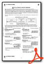
Weather Minimums

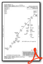
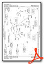
Standard Terminal Arrival (STAR) Charts

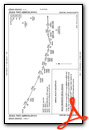
Instrument Approach Procedure (IAP) Charts
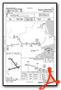

Departure Procedure (DP) Charts

Nearby Airports with Instrument Procedures
| ID | Name | Heading / Distance | ||
|---|---|---|---|---|
 |
KLWM | Lawrence Municipal Airport | 311° | 12.2 |
|
KBOS | General Edward Lawrence Logan International Airport | 196° | 13.9 |
|
KBED | Laurence G Hanscom Field Airport | 247° | 17.9 |
|
KOWD | Norwood Memorial Airport | 205° | 26.2 |
|
6B6 | Minute Man Air Field Airport | 254° | 27.7 |
|
KASH | Boire Field Airport | 294° | 29.0 |
|
KPSM | Portsmouth International At Pease Airport | 007° | 29.9 |
|
KMHT | Manchester Boston Regional Airport | 312° | 31.1 |
|
KGHG | Marshfield Municipal - George Harlow Field Airport | 159° | 31.1 |
|
3B4 | Seacoast Airfield Airport | 010° | 34.1 |
|
1B9 | Mansfield Municipal Airport | 199° | 37.2 |
|
KFIT | Fitchburg Municipal Airport | 267° | 37.4 |
Airport Images
Do you have a recent image of this airport? Upload it here!


