Login
Register


BOS
General Edward Lawrence Logan International Airport
Official FAA Data Effective 2026-01-22 0901Z
Chart Supplement

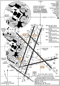
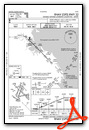
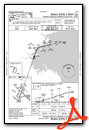
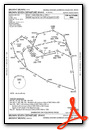
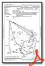
KBOS Airport Diagram
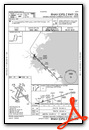
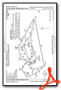
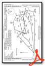
VFR Chart of KBOS
Sectional Charts at SkyVector.com
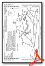
IFR Chart of KBOS
Enroute Charts at SkyVector.com
Location Information for KBOS
Coordinates: N42°21.78' / W71°0.38'Located 01 miles E of Boston, Massachusetts on 2384 acres of land. View all Airports in Massachusetts.
Surveyed Elevation is 19 feet MSL.
Operations Data
|
|
Airport Communications
| D-ATIS: | 135.0 ;ARR (617-455-3003) 135.0 ;DEP (617-455-3003) |
|---|---|
| ASOS: | 135.0 Tel. 339-746-6855 |
| BOSTON TOWER: | 124.725 ;HELICOPTERS 128.8 ;WEST 132.225 ;EAST 257.8 |
| BOSTON GROUND: | 121.75 121.9 |
| BOSTON APPROACH: | 118.25 ;NORTH 120.6 ;WEST 127.2 ;SOUTH 263.1 |
| BOSTON DEPARTURE: | 133.0 |
| IC: | 120.6 ;WEST 263.1 |
| CLEARANCE DELIVERY: | 121.65 257.8 |
| CLASS B: | 124.1 ;091-269 124.4 ;270-090 |
| EMERG: | 121.5 243.0 |
| PRE TAXI CLNC: | 121.65 |
| WOONS STAR: | 120.6 263.1 |
| RAMP CTL: | 134.05 |
| UNICOM: | 122.950 |
| ATIS at OWD (12.7 SW): | 119.95 |
| ASOS at OWD (12.7 SW): | 119.95 781-762-4314 |
| ATIS at BVY (13.9 N): | 119.2 |
- ASDE-X IN USE. OPERATE TRANSPONDERS WITH ALTITUDE REPORTING MODE AND ADS-B (IF EQUIPPED) ENABLED ON ALL AIRPORT SURFACES.
Nearby Navigation Aids
|
| ||||||||||||||||||||||||||||||||||||||||||||||||||||||||||||


Runway 15R/33L
| Dimensions: | 10083 x 150 feet / 3073 x 46 meters | |
|---|---|---|
| Surface: | Asphalt / Grooved in Excellent Condition | |
| Weight Limits: | S-120, D-250, ST-550
PCR VALUE: 800/F/C/X/T
| |
| Edge Lighting: | High Intensity | |
| Runway 15R | Runway 33L | |
| Coordinates: | N42°22.46' / W71°1.07' | N42°21.28' / W70°59.50' |
| Elevation: | 18.9 | 15.7 |
| Traffic Pattern: | Left | Left |
| Runway Heading: | 135° True | 315° True |
| Displaced Threshold: | 882 Feet | |
| Declared Distances: | TORA:10083 TODA:10083 ASDA:10083 LDA:9202 | TORA:10083 TODA:10083 ASDA:10083 LDA:10083 |
| Markings: | Precision Instrument in good condition. | Precision Instrument in good condition. |
| Glide Slope Indicator | P4L (3.00° Glide Path Angle) | P4R (3.00° Glide Path Angle) |
| RVR Equipment | Touchdown Midfield Rollout | Touchdown Midfield Rollout |
| Approach Lights: | MALSR 1,400 Foot Medium-intensity Approach Lighting System with runway alignment indicator lights. | ALSF2 Standard 2,400 Foot High-intensity Approach Lighting System with sequenced flashers, CATEGORY II or III Configuration. |
| Centerline Lights: | Yes | Yes |
| Obstacles: | 62 ft Trees 3040 ft from runway, 140 ft left of center APCH RATIO 50:1 FROM DSPLCD THR. |
160 ft Boat 5075 ft from runway |
Runway 04R/22L
| Dimensions: | 10006 x 150 feet / 3050 x 46 meters | |
|---|---|---|
| Surface: | Asphalt / Grooved in Good Condition | |
| Weight Limits: | S-120, D-250, ST-550
PCR VALUE: 830/F/C/X/T
| |
| Edge Lighting: | High Intensity | |
| Runway 04R | Runway 22L | |
| Coordinates: | N42°21.06' / W71°0.71' | N42°22.61' / W70°59.96' |
| Elevation: | 18.8 | 14.5 |
| Traffic Pattern: | Left | Left |
| Runway Heading: | 20° True | 200° True |
| Displaced Threshold: | 1155 Feet | 1199 Feet |
| Declared Distances: | TORA:10006 TODA:10006 ASDA:10006 LDA:8851 | TORA:10006 TODA:10006 ASDA:10006 LDA:8806 |
| Markings: | Precision Instrument in good condition. | Precision Instrument in good condition. |
| Glide Slope Indicator | P4L (3.00° Glide Path Angle) | P4R (3.00° Glide Path Angle) UNUSBL BYD 7 DEGS LEFT OF CNTRLN. |
| RVR Equipment | Touchdown Midfield Rollout | Touchdown Midfield Rollout |
| Approach Lights: | ALSF2 Standard 2,400 Foot High-intensity Approach Lighting System with sequenced flashers, CATEGORY II or III Configuration. | MALSF 1,400 Foot Medium-intensity Approach Lighting System with sequenced flashers. |
| Centerline Lights: | Yes | Yes |
| Obstacles: | 157 ft Boat 1550 ft from runway APCH RATIO 17:1 FROM DSPLCD THR; 43:1 WHEN CHANNEL IS CLEAR. |
45 ft Boat 525 ft from runway APCH RATIO 38:1 FROM DSPLCD THR. |
Runway 04L/22R
| Dimensions: | 7864 x 150 feet / 2397 x 46 meters | |
|---|---|---|
| Surface: | Asphalt / Grooved in Good Condition | |
| Weight Limits: | S-120, D-250, ST-550
PCR VALUE: 800/F/C/X/T
| |
| Edge Lighting: | High Intensity | |
| Runway 04L | Runway 22R | |
| Coordinates: | N42°21.48' / W71°0.86' | N42°22.70' / W71°0.27' |
| Elevation: | 13.9 | 14.9 |
| Traffic Pattern: | Left | Left |
| Runway Heading: | 20° True | 200° True |
| Displaced Threshold: | 819 Feet | |
| Declared Distances: | TORA:7864 TODA:7864 ASDA:7864 LDA:7864 | TORA:7864 TODA:7864 ASDA:7864 LDA:7046 |
| Markings: | Precision Instrument in good condition. | Precision Instrument in good condition. |
| Glide Slope Indicator | P4L (3.10° Glide Path Angle) | P4L (3.00° Glide Path Angle) |
| RVR Equipment | Touchdown Rollout | Touchdown Rollout |
| REIL: | Yes | |
| Centerline Lights: | Yes | Yes |
| Obstacles: | 161 ft Boat 3250 ft from runway | 44 ft Boat 670 ft from runway APCH RATIO 33:1 FROM DSPLCD THR; 50:1 TO THR WHEN CHANNEL IS CLEAR. |
Runway 09/27
| Dimensions: | 7001 x 150 feet / 2134 x 46 meters | |
|---|---|---|
| Surface: | Asphalt / Grooved in Good Condition | |
| Weight Limits: | S-120, D-250, ST-550
PCR VALUE: 810/F/C/X/T
| |
| Edge Lighting: | High Intensity | |
| Runway 09 | Runway 27 | |
| Coordinates: | N42°21.35' / W71°0.77' | N42°21.61' / W70°59.26' |
| Elevation: | 16.7 | 14.8 |
| Traffic Pattern: | Left | Left |
| Runway Heading: | 77° True | 257° True |
| Declared Distances: | TORA:7001 TODA:7001 ASDA:7001 LDA:7001 | TORA:7001 TODA:7001 ASDA:7001 LDA:7001 |
| Markings: | Basic in good condition. | Precision Instrument in good condition. |
| Glide Slope Indicator | P4L (3.00° Glide Path Angle) | |
| RVR Equipment | Touchdown Rollout | Touchdown Rollout |
| REIL: | Yes | |
| Centerline Lights: | Yes | Yes |
| Obstacles: | 158 ft Boat 2050 ft from runway | 45 ft Boat 500 ft from runway |
Runway 14/32
| Dimensions: | 5000 x 100 feet / 1524 x 30 meters | |
|---|---|---|
| Surface: | Asphalt / Grooved in Good Condition | |
| Weight Limits: | S-120, D-250, ST-490
PCR VALUE: 780/F/C/X/T
| |
| Edge Lighting: | High Intensity | |
| Runway 14 | Runway 32 | |
| Coordinates: | N42°21.40' / W71°1.40' | N42°20.92' / W71°0.49' |
| Elevation: | 16.0 | 19.1 |
| Runway Heading: | 125° True | 305° True |
| Declared Distances: | TORA:5000 TODA:5000 ASDA:5000 | LDA:5000 |
| Markings: | Basic in good condition. | Precision Instrument in good condition. |
| Glide Slope Indicator | P4L (3.00° Glide Path Angle) | |
| REIL: | Yes | |
| Obstacles: | 174 ft Building 1364 ft from runway, 70 ft left of center APPROACHES TO RWY 14 NOT AUTHORIZED. |
|
Runway 15L/33R
| Dimensions: | 2557 x 100 feet / 779 x 30 meters | |
|---|---|---|
| Surface: | Asphalt in Good Condition | |
| Weight Limits: | S-120, D-250, ST-550
PCR VALUE: 850/F/C/X/T
| |
| Edge Lighting: | Medium Intensity | |
| Runway 15L | Runway 33R | |
| Coordinates: | N42°22.39' / W71°0.52' | N42°22.09' / W71°0.12' |
| Elevation: | 14.8 | 14.0 |
| Traffic Pattern: | Left | Left |
| Runway Heading: | 135° True | 315° True |
| Declared Distances: | TORA:2557 TODA:2557 ASDA:2557 LDA:2557 | TORA:2557 TODA:2557 ASDA:2557 LDA:2557 |
| Markings: | Basic in good condition. | Basic in good condition. |
| Glide Slope Indicator | P4R (3.00° Glide Path Angle) | |
Services Available
| Fuel: | 100LL (blue), Jet-A |
|---|---|
| Transient Storage: | NONE |
| Airframe Repair: | MAJOR |
| Engine Repair: | MAJOR |
| Bottled Oxygen: | HIGH/LOW |
| Bulk Oxygen: | HIGH/LOW |
| Other Services: | AIR FREIGHT SERVICES,CARGO HANDLING SERVICES,CHARTER SERVICE |
Ownership Information
| Ownership: | Publicly owned | |
|---|---|---|
| Owner: | MASS PORT AUTHORITY | |
| ONE HARBORSIDE DR STE 200S | ||
| BOSTON, MA 02128 | ||
| 617-428-2800 | ||
| Manager: | EDWARD FRENI | |
| LOGAN INTERNATIONAL AIRPORT, HARBORSIDE DR STE 200S | ||
| EAST BOSTON, MA 02128-2909 | ||
| 617-567-5400 | ||
Other Remarks
- BIRDS ON & INVOF ARPT.
- NMRS CRANES ON AND INVOF ARPT.
- RWY 14/32 UNIDIRECTIONAL; NO LDGS RWY 14; NO TKOFS RWY 32.
- PILOTS SHOULD COMPLETE ALL CALCULATIONS PRIOR TO PUSHBACK FROM GATE.
- RWY STATUS LGTS IN OPN.
- FOR NOISE ABATEMENT, RWY 15R IS PREFERRED FOR TKOF, RWY 33L IS PREFERRED FOR LDG. FOR MORE INFO ON NOISE ABATEMENT PROCS CALL 617-561-3333.
- THE USE OF THE RNAV SIDS AT BOSTON LOGAN ARE CRITICAL TO RDCG NOISE AND ACHIEVING OUR FLY QUIET GOALS. MASSPORT AND THE FAA ENCOURAGE PILOTS TO USE PUBLD RNAV FLIGHT PROCS AT BOSTON LOGAN ARPT WHENEVER POSS. ALL ACFT THAT HAVE REQD ALTS ABV 10,000 FT SHOULD BE FILING RNAV SIDS WITH FAA ATC. CTC MASSPORT'S NOISE ABATEMENT OFC AT 617-561-3333 WITH ANY QNS.
- NO RON PARKING FOR NON-TENANT CHARTER AIRCRAFT WITHOUT PRIOR MASSPORT PERMISSION.
- TERMINAL E; NORTH & SOUTH CARGO ARRIVALS CTC MASSPORT GATE CONTROL ON FREQ 131.1 BEFORE ENTERING/DEPARTING RAMP AREA.
- AVBL FOR DEPARTURE ONLY.
- ENGINEERING MATERIALS ARRESTING SYSTEM (EMAS) 190 FT IN LENGTH BY 170 FT IN WIDTH LCTD AT DER 04L.
- ENGINEERED MATERIALS ARRESTING SYSTEM (EMAS) 158 FT IN LENGTH BY 170 FT IN WIDTH LCTD AT DER 15R.
Weather Minimums

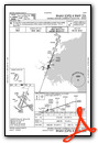
Standard Terminal Arrival (STAR) Charts


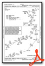


Instrument Approach Procedure (IAP) Charts
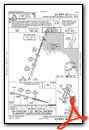
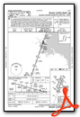
- ILS OR LOC RWY 04R

- ILS OR LOC RWY 15R

- ILS OR LOC RWY 22L

- ILS OR LOC RWY 27
- ILS OR LOC RWY 33L

- ILS RWY 04R (SA CAT I)
- ILS RWY 33L (SA CAT I)
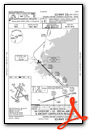
- ILS RWY 04R (CAT II - III)
- ILS RWY 33L (CAT II - III)

- RNAV (RNP) X RWY 33L

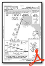
- RNAV (GPS) RWY 04L
- RNAV (GPS) RWY 04R
- RNAV (GPS) RWY 15R

- RNAV (GPS) RWY 27
- RNAV (GPS) RWY 32
- RNAV (GPS) X RWY 22L
- RNAV (GPS) Y RWY 22L
- RNAV (GPS) Z RWY 33L
- LIGHT VISUAL RWY 33L

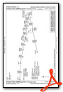
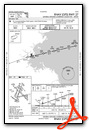
Departure Procedure (DP) Charts
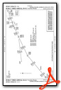
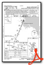
- BLZZR SIX (RNAV)
- BLZZR SIX (RNAV), CONT.1
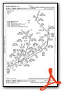
- BRUWN SEVEN (RNAV)
- BRUWN SEVEN (RNAV), CONT.1
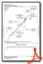
- CELTK SEVEN (RNAV)
- CELTK SEVEN (RNAV), CONT.1
- HYLND SEVEN (RNAV)
- HYLND SEVEN (RNAV), CONT.1
- LBSTA EIGHT (RNAV)

- LBSTA EIGHT (RNAV), CONT.1
- LOGAN FOUR

- LOGAN FOUR, CONT.1

- PATSS SEVEN (RNAV)
- PATSS SEVEN (RNAV), CONT.1

- REVSS SIX (RNAV)

- REVSS SIX (RNAV), CONT.1

- SSOXS SEVEN (RNAV)

- SSOXS SEVEN (RNAV), CONT.1
- WYLYY FIVE (RNAV)
Nearby Airports with Instrument Procedures
| ID | Name | Heading / Distance | ||
|---|---|---|---|---|
 |
KOWD | Norwood Memorial Airport | 215° | 12.7 |
|
KBVY | Beverly Regional Airport | 016° | 13.9 |
|
KBED | Laurence G Hanscom Field Airport | 297° | 14.1 |
|
KGHG | Marshfield Municipal - George Harlow Field Airport | 136° | 21.8 |
|
KLWM | Lawrence Municipal Airport | 346° | 21.9 |
|
1B9 | Mansfield Municipal Airport | 201° | 23.3 |
|
6B6 | Minute Man Air Field Airport | 284° | 23.5 |
|
1B6 | Hopedale Industrial Park Airport | 235° | 27.2 |
|
KTAN | Taunton Municipal/King Field Airport | 180° | 29.3 |
|
KPYM | Plymouth Municipal Airport | 155° | 29.9 |
|
KASH | Boire Field Airport | 318° | 33.8 |
|
KSFZ | North Central State Airport | 219° | 34.2 |
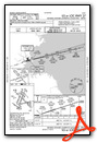
Airport Images
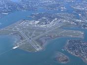
By: jfreesemd


