Login
Register


BXM
Brunswick Exec Airport
Official FAA Data Effective 2026-02-19 0901Z
Chart Supplement

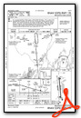
VFR Chart of KBXM
Sectional Charts at SkyVector.com
IFR Chart of KBXM
Enroute Charts at SkyVector.com
Location Information for KBXM
Coordinates: N43°53.54' / W69°56.33'Located 02 miles SE of Brunswick, Maine on 920 acres of land. View all Airports in Maine.
Surveyed Elevation is 74 feet MSL.
Operations Data
|
|
Airport Communications
| AWOS-3PT: | 134.875 Tel. 207-409-1747 |
|---|---|
| PORTLAND APPROACH: | 119.75 ;112-292 120.4 ;293-111 269.35 ;112-292 299.2 ;293-111 |
| PORTLAND DEPARTURE: | 119.75 ;112-292 120.4 ;293-111 269.35 ;112-292 299.2 ;293-111 |
| CLEARANCE DELIVERY: | 123.65 |
| CTAF: | 122.725 |
| UNICOM: | 122.725 |
| ASOS at IWI (10.6 NE): | 135.725 207-882-8094 |
| AWOS-3PT at LEW (17.6 NW): | 118.025 207-783-2806 |
| ASOS at PWM (21.8 SW): | 119.05 207-419-5584 |
- APCH/DEP SVC PRVDD BY BOSTON ARTCC ON FREQS 128.2/263.05 (WATERBORO RCAG) WHEN PORTLAND APCH CTL CLSD.
Nearby Navigation Aids
|
| ||||||||||||||||||||||||||||||||||||||||||||||||||||||||||||


Runway 01L/19R
CLSD INDEFLY. | ||
| Dimensions: | 8000 x 200 feet / 2438 x 61 meters | |
|---|---|---|
| Surface: | Asphalt-Concrete | |
| Edge Lighting: | High Intensity | |
| Runway 01L | Runway 19R | |
| Coordinates: | N43°52.88' / W69°56.33' | N43°54.19' / W69°56.49' |
| Elevation: | 63.4 | 74.2 |
| Traffic Pattern: | Right | Left |
| Runway Heading: | 354° True | 174° True |
| Markings: | Precision Instrument in fair condition. | Precision Instrument in fair condition. |
| Glide Slope Indicator | P4L (3.00° Glide Path Angle) | P4L (3.00° Glide Path Angle) |
Runway 01R/19L
| Dimensions: | 8000 x 200 feet / 2438 x 61 meters | |
|---|---|---|
| Surface: | Asphalt-Concrete | |
| Edge Lighting: | High Intensity | |
| Runway 01R | Runway 19L | |
| Coordinates: | N43°52.89' / W69°56.17' | N43°54.20' / W69°56.33' |
| Elevation: | 61.6 | 73.7 |
| Traffic Pattern: | Right | Left |
| Runway Heading: | 354° True | 174° True |
| Markings: | Precision Instrument in fair condition. | Precision Instrument in fair condition. |
| Glide Slope Indicator | P4L (3.00° Glide Path Angle) | P4L (3.00° Glide Path Angle) |
| Approach Lights: | MALSR 1,400 Foot Medium-intensity Approach Lighting System with runway alignment indicator lights. | |
| REIL: | Yes | |
Services Available
| Fuel: | 100LL (blue), Jet A+ |
|---|---|
| Transient Storage: | Hangars,Tiedowns |
| Airframe Repair: | MAJOR |
| Engine Repair: | MAJOR |
| Bottled Oxygen: | HIGH/LOW |
| Bulk Oxygen: | HIGH/LOW |
| Other Services: | CHARTER SERVICE,PILOT INSTRUCTION,AIRCRAFT RENTAL |
Ownership Information
| Ownership: | Publicly owned | |
|---|---|---|
| Owner: | MIDCOAST RGNL REDEVELOPMENT AUTH | |
| 15 TERMINAL DRIVE | ||
| BRUNSWICK, ME 04011 | ||
| (207) 798-6512 | ||
| Manager: | JIM NALL | |
| 15 TERMINAL DRIVE | ||
| BRUNSWICK, ME 04011 | ||
| 207-406-2081 | ||
Other Remarks
- BIRDS AND DEER INVOF OF ARPT.
- FOR CD CTC PORTLAND APCH AT 207-874-7320, WHEN APCH CLSD CTC BOSTON ARTCC AT 603-879-6859.
- CALM WIND RWY.
- ACTVT MALSR RWY 01R; REIL RWY 19L; PAPI RWY 01R & 19L; HIRL RWY 01R/19L - CTAF.
Weather Minimums

Instrument Approach Procedure (IAP) Charts


Nearby Airports with Instrument Procedures
| ID | Name | Heading / Distance | ||
|---|---|---|---|---|
 |
KIWI | Wiscasset Airport | 067° | 10.7 |
|
KLEW | Auburn/Lewiston Municipal Airport | 302° | 17.6 |
|
KPWM | Portland International Jetport Airport | 227° | 21.9 |
|
KAUG | Augusta State Airport | 013° | 26.4 |
|
81B | Oxford County Regional Airport | 304° | 28.4 |
|
B19 | Biddeford Municipal Airport | 222° | 34.6 |
|
KRKD | Knox County Regional Airport | 074° | 37.7 |
|
KWVL | Waterville Regional Airport | 016° | 40.1 |
|
KIZG | White Mountain Regional Airport | 278° | 44.1 |
|
KSFM | Sanford Seacoast Regional Airport | 228° | 44.9 |
|
0B1 | Bethel Regional Airport | 310° | 49.4 |
|
KOWK | Central Maine/Norridgewock Airport | 003° | 49.5 |


