Login
Register


AUG
Augusta State Airport
Official FAA Data Effective 2026-02-19 0901Z
Chart Supplement

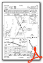
KAUG Airport Diagram

VFR Chart of KAUG
Sectional Charts at SkyVector.com
IFR Chart of KAUG
Enroute Charts at SkyVector.com
Location Information for KAUG
Coordinates: N44°19.24' / W69°47.84'Located 01 miles NW of Augusta, Maine on 406 acres of land. View all Airports in Maine.
Surveyed Elevation is 351 feet MSL.
Operations Data
|
|
Airport Communications
| ASOS: | 118.325 Tel. 207-623-0432 |
|---|---|
| PORTLAND APPROACH: | 128.35 299.2 |
| PORTLAND DEPARTURE: | 128.35 299.2 |
| CLEARANCE DELIVERY: | 119.95 299.2 |
| CTAF: | 123.000 |
| UNICOM: | 123.000 |
| AWOS-3PT at WVL (13.8 NE): | 118.375 207-877-0519 |
| ASOS at IWI (21.9 S): | 135.725 207-882-8094 |
| AWOS-AV at OWK (23.9 N): | 123.075 |
- APCH/DEP SVC PRVDD BY BOSTON ARTCC ON FREQS 128.2/263.05 (112-292) (WATERBORO RCAG); FREQS 120.25/290.50 (293-111) (BANGOR RCAG) WHEN PORTLAND APCH CTL CLSD.
Nearby Navigation Aids
|
| ||||||||||||||||||||||||||||||||||||||||||||||||||||||||||||


Runway 17/35
| Dimensions: | 5002 x 100 feet / 1525 x 30 meters | |
|---|---|---|
| Surface: | Asphalt / Grooved in Good Condition | |
| Weight Limits: | S-50, D-60 | |
| Edge Lighting: | High Intensity | |
| Runway 17 | Runway 35 | |
| Coordinates: | N44°19.66' / W69°48.22' | N44°18.93' / W69°47.70' |
| Elevation: | 310.7 | 347.2 |
| Traffic Pattern: | Left | Left |
| Runway Heading: | 153° True | 333° True |
| Declared Distances: | TORA:5002 TODA:5002 ASDA:5002 LDA:5002 | TORA:5002 TODA:5002 ASDA:5002 LDA:5002 |
| Markings: | Precision Instrument in good condition. | Precision Instrument in good condition. |
| Glide Slope Indicator | P4L (3.00° Glide Path Angle) | P4L (3.00° Glide Path Angle) |
| Approach Lights: | MALSR 1,400 Foot Medium-intensity Approach Lighting System with runway alignment indicator lights. | |
| REIL: | Yes | |
| Obstacles: | 6 ft Tree 210 ft from runway, 20 ft left of center APCH SLP GTR THAN 45 DEG. 7-8 FT BRUSH 190 FT FM THR, 110-120 FT R OF CNTRLN. |
8 ft Tree 201 ft from runway, 90 ft right of center ROAD 240 FT R, 0-200 FT; 3-7 FT BRUSH 195-200 FT FM THR, 65-130 FT R OF CNTRLN. |
Runway 08/26
| Dimensions: | 2613 x 75 feet / 796 x 23 meters | |
|---|---|---|
| Surface: | Asphalt in Fair Condition | |
| Weight Limits: | S-30 | |
| Edge Lighting: | Medium Intensity | |
| Runway 08 | Runway 26 | |
| Coordinates: | N44°19.04' / W69°47.87' | N44°19.24' / W69°47.34' |
| Elevation: | 349.4 | 351.6 |
| Traffic Pattern: | Left | Left |
| Runway Heading: | 62° True | 242° True |
| Declared Distances: | TORA:2613 TODA:2613 ASDA:2613 LDA:2613 | TORA:2613 TODA:2613 ASDA:2613 LDA:2613 |
| Markings: | Non-Precision Instrument in good condition. | Non-Precision Instrument in good condition. |
| Obstacles: | 16 ft Trees 287 ft from runway, 80 ft left of center | 6 ft Fence 201 ft from runway, 131 ft left of center ROAD & FENCE L OF APCH, 0-200 FT FM RWY END, LGTD. |
Services Available
| Fuel: | 100LL (blue), Jet-A |
|---|---|
| Transient Storage: | Hangars,Tiedowns CALL 207-622-1211 FOR HNGR AVBL. |
| Airframe Repair: | MAJOR |
| Engine Repair: | MAJOR |
| Bottled Oxygen: | NONE |
| Bulk Oxygen: | NONE |
| Other Services: | AIR FREIGHT SERVICES,AIR AMBULANCE SERVICES,CHARTER SERVICE,PILOT INSTRUCTION,AIRCRAFT RENTAL,AIRCRAFT SALES |
Ownership Information
| Ownership: | Publicly owned | |
|---|---|---|
| Owner: | STATE OF MAINE | |
| 16 STATE HOUSE STATION | ||
| AUGUSTA, ME 04333 | ||
| 207-624-3250 | ||
| Manager: | JOHN GUIMOND | |
| 75 AIRPORT RD | ||
| AUGUSTA, ME 04330 | ||
| 207-626-2306 | ||
Other Remarks
- RWY 35 DESIGNATED CALM WIND RWY.
- ACR RAMP CLSD TO GA TFC.
- RWY 17/35 HAVE EMAS CATEGORY B2.
- FOR CD WHEN PORTLAND APCH CLSD, CTC BOSTON ARTCC AT 603-879-6859.
- PILOTS CONDUCTING EFVS OPS; BE AWARE LED ALS IN USE RWY 17.
- TWY F EAST CLSD TO ALL ACFT WITH WING SPAN GTR THAN 45 FT.
- LDG FEE FOR MULTI-ENG ACFT; FEE WAIVED WITH FUEL PURCHASE.
- BIRDS & DEER ON & INVOF ARPT.
- 0LL FOR FUEL AFT NML BUS HRS CALL 207-622-2507.
- ACTVT MALSR RWY 17; REIL RWY 35; PAPI RWY 17 & 35; HIRL RWY 17/35; MIRL RWY 08/26 - CTAF.
- ENGINEERED MATERIALS ARRESTING SYSTEM (EMAS) 130 FT IN LENGTH BY 122 FT IN WIDTH LCTD AT DER 17.
- ENGINEERED MATERIALS ARRESTING SYSTEM (EMAS) 150 FT IN LENGTH BY 122 FT IN WIDTH LCTD AT DER 35.
Weather Minimums

Instrument Approach Procedure (IAP) Charts


Nearby Airports with Instrument Procedures
| ID | Name | Heading / Distance | ||
|---|---|---|---|---|
 |
KWVL | Waterville Regional Airport | 022° | 13.8 |
|
KIWI | Wiscasset Airport | 170° | 21.9 |
|
KOWK | Central Maine/Norridgewock Airport | 352° | 23.9 |
|
KBXM | Brunswick Exec Airport | 193° | 26.4 |
|
KLEW | Auburn/Lewiston Municipal Airport | 232° | 26.6 |
|
81B | Oxford County Regional Airport | 251° | 31.1 |
|
2B7 | Pittsfield Municipal Airport | 033° | 32.4 |
|
KRKD | Knox County Regional Airport | 117° | 33.9 |
|
KBST | Belfast Municipal Airport | 080° | 34.2 |
|
0B1 | Bethel Regional Airport | 278° | 44.0 |
|
KPWM | Portland International Jetport Airport | 208° | 46.2 |
|
1B0 | Dexter Regional Airport | 030° | 47.5 |
Airport Images
Do you have a recent image of this airport? Upload it here!


