Login
Register


RKD
Knox County Regional Airport
Official FAA Data Effective 2026-02-19 0901Z
Chart Supplement

VFR Chart of KRKD
Sectional Charts at SkyVector.com
IFR Chart of KRKD
Enroute Charts at SkyVector.com
Location Information for KRKD
Coordinates: N44°3.61' / W69°5.98'Located 03 miles S of Rockland, Maine on 538 acres of land. View all Airports in Maine.
Surveyed Elevation is 55 feet MSL.
Operations Data
|
|
Airport Communications
| AWOS-3PT: | 119.025 Tel. 207-594-7946 |
|---|---|
| PORTLAND APPROACH: | 120.4 299.2 |
| PORTLAND DEPARTURE: | 120.4 299.2 |
| CLEARANCE DELIVERY: | 123.8 |
| UNICOM: | 123.050 |
| CTAF: | 123.050 |
| AWOS-AV at ME78 (20.0 SW): | 123.0 |
| AWOS-AV at BST (21.3 N): | 122.975 207-930-7071 |
| ASOS at IWI (27.1 W): | 135.725 207-882-8094 |
- APCH/DEP SVC PRVDD BY BOSTON ARTCC ON FREQS 128.2/263.05 (112-292) (WATERBORO RCAG); FREQS 124.25/290.50 (293-111) (BANGOR RCAG) WHEN PORTLAND APCH CTL CLSD.
Nearby Navigation Aids
|
| ||||||||||||||||||||||||||||||||||||||||||||||||||||||||||||


Runway 13/31
| Dimensions: | 5412 x 100 feet / 1650 x 30 meters | |
|---|---|---|
| Surface: | Asphalt / Grooved in Excellent Condition | |
| Weight Limits: | S-65, D-80 | |
| Edge Lighting: | High Intensity | |
| Runway 13 | Runway 31 | |
| Coordinates: | N44°3.71' / W69°6.59' | N44°3.40' / W69°5.43' |
| Elevation: | 45.6 | 54.7 |
| Traffic Pattern: | Left | Left |
| Runway Heading: | 111° True | 291° True |
| Displaced Threshold: | 400 Feet | |
| Declared Distances: | TORA:5412 TODA:5412 ASDA:5412 LDA:5012 | TORA:5412 TODA:5412 ASDA:5412 LDA:5412 |
| Markings: | Precision Instrument in good condition. | Precision Instrument in good condition. |
| Glide Slope Indicator | P4R (3.00° Glide Path Angle) | P4L (3.00° Glide Path Angle) |
| Approach Lights: | MALSR 1,400 Foot Medium-intensity Approach Lighting System with runway alignment indicator lights. | |
| REIL: | Yes | |
| Obstacles: | 40 ft Trees 450 ft from runway, 475 ft right of center | |
Runway 03/21
| Dimensions: | 4000 x 100 feet / 1219 x 30 meters | |
|---|---|---|
| Surface: | Asphalt in Good Condition | |
| Weight Limits: | S-65, D-80 | |
| Edge Lighting: | Medium Intensity | |
| Runway 03 | Runway 21 | |
| Coordinates: | N44°3.36' / W69°6.04' | N44°4.00' / W69°5.83' |
| Elevation: | 50.2 | 55.1 |
| Traffic Pattern: | Left | Left |
| Runway Heading: | 13° True | 193° True |
| Declared Distances: | TORA:4000 TODA:4000 ASDA:4000 LDA:4000 | TORA:4000 TODA:4000 ASDA:4000 LDA:4000 |
| Markings: | Non-Precision Instrument in good condition. | Non-Precision Instrument in good condition. |
| Glide Slope Indicator | P4L (3.00° Glide Path Angle) | |
| REIL: | Yes | |
| Obstacles: | 26 ft Trees 357 ft from runway, 270 ft right of center | 50 ft Trees 525 ft from runway, 250 ft left of center |
Services Available
| Fuel: | 100LL (blue), Jet-A |
|---|---|
| Transient Storage: | Hangars,Tiedowns CALL FBO 207-594-2171 FOR AVBL. |
| Airframe Repair: | MAJOR |
| Engine Repair: | MAJOR |
| Bottled Oxygen: | LOW |
| Bulk Oxygen: | LOW |
| Other Services: | AIR FREIGHT SERVICES,CHARTER SERVICE,PILOT INSTRUCTION,AIRCRAFT RENTAL |
Ownership Information
| Ownership: | Publicly owned | |
|---|---|---|
| Owner: | KNOX COUNTY | |
| 62 UNION ST | ||
| ROCKLAND, ME 04841 | ||
| 207-594-0420 | ||
| Manager: | JACOB JOHNSON | |
| 5 AIRPORT RD | ||
| OWLS HEAD, ME 04854 | ||
| 207-701-1715 | ||
Other Remarks
- DEER & SEAGULLS ON & INVOF ARPT.
- VOLUNTARY NGT CUFREW IN EFCT 2230-0600.
- NOISE ABATEMENT PROCS IN EFCT, CALL 207-596-0617 OR VISIT WEBSITE FOR SPECIFIC INSTRUCTIONS.
- FOR CD WHEN APCH CLSD CTC BOSTON ARTCC AT 603-879-6859.
- ACTVT MALSR RWY 13; REIL RWY 03 & 31; PAPI RWY 03, 13 & 31; HIRL RWY 13/31; MIRL RWY 03/21 - CTAF.
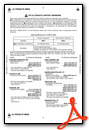
Weather Minimums

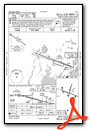
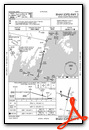
Instrument Approach Procedure (IAP) Charts


Nearby Airports with Instrument Procedures
| ID | Name | Heading / Distance | ||
|---|---|---|---|---|
 |
KBST | Belfast Municipal Airport | 010° | 21.3 |
|
KIWI | Wiscasset Airport | 257° | 27.2 |
|
KAUG | Augusta State Airport | 297° | 33.9 |
|
KBXM | Brunswick Exec Airport | 254° | 37.7 |
|
KWVL | Waterville Regional Airport | 319° | 37.7 |
|
KBHB | Hancock County/Bar Harbor Airport | 053° | 39.5 |
|
2B7 | Pittsfield Municipal Airport | 344° | 44.1 |
|
KBGR | Bangor International Airport | 014° | 46.3 |
|
KLEW | Auburn/Lewiston Municipal Airport | 269° | 51.2 |
|
KOWK | Central Maine/Norridgewock Airport | 320° | 51.3 |
|
KOLD | Dewitt Field/Old Town Municipal Airport | 018° | 56.6 |
|
1B0 | Dexter Regional Airport | 354° | 57.0 |


