Login
Register


PKV
Calhoun County Airport
Official FAA Data Effective 2026-01-22 0901Z
Chart Supplement

VFR Chart of KPKV
Sectional Charts at SkyVector.com
IFR Chart of KPKV
Enroute Charts at SkyVector.com
Location Information for KPKV
Coordinates: N28°39.20' / W96°40.96'Located 03 miles NW of Port Lavaca, Texas on 200 acres of land. View all Airports in Texas.
Surveyed Elevation is 32 feet MSL.
Operations Data
|
|
Airport Communications
| AWOS-3: | 118.275 Tel. 361-552-3060 |
|---|---|
| UNICOM: | 122.800 |
| CTAF: | 122.800 |
| ATIS at VCT (17.3 NW): | 119.025 |
| ASOS at VCT (18.1 NW): | 361-433-5979 |
| ASOS at PSX (23.2 E): | 118.025 361-972-0101 |
- APCH/DEP CTL SVC PRVDD BY HOUSTON ARTCC (ZHU) ON FREQS 135.05/353.6 (VICTORIA RCAG).
Nearby Navigation Aids
|
| ||||||||||||||||||||||||||||||||||||


Runway 14/32
| Dimensions: | 5004 x 75 feet / 1525 x 23 meters | |
|---|---|---|
| Surface: | Asphalt in Excellent Condition | |
| Weight Limits: | S-26 | |
| Edge Lighting: | Medium Intensity | |
| Runway 14 | Runway 32 | |
| Coordinates: | N28°39.58' / W96°41.15' | N28°38.91' / W96°40.61' |
| Elevation: | 29.9 | 28.5 |
| Traffic Pattern: | Left | Right |
| Runway Heading: | 144° True | 324° True |
| Markings: | Non-Precision Instrument in good condition. | Non-Precision Instrument in good condition. |
| Glide Slope Indicator | P2L (3.00° Glide Path Angle) | P2L (3.00° Glide Path Angle) |
| Obstacles: | 13 ft Road 560 ft from runway | 13 ft Road 475 ft from runway |
Runway 05/23
| Dimensions: | 2432 x 60 feet / 741 x 18 meters | |
|---|---|---|
| Surface: | Turf in Excellent Condition | |
| Runway 05 | Runway 23 | |
| Coordinates: | N28°38.99' / W96°41.32' | N28°39.22' / W96°40.95' |
| Elevation: | 32.0 | 29.6 |
| Runway Heading: | 54° True | 234° True |
| Displaced Threshold: | 428 Feet | |
| Markings: | in poor condition. | in poor condition. |
| Obstacles: | 22 ft Tree 141 ft from runway, 70 ft left of center | |
Services Available
| Fuel: | 100LL (blue), Jet-A |
|---|---|
| Transient Storage: | Hangars,Tiedowns |
| Airframe Repair: | MAJOR |
| Engine Repair: | MAJOR |
| Bottled Oxygen: | NONE |
| Bulk Oxygen: | NONE |
Ownership Information
| Ownership: | Publicly owned | |
|---|---|---|
| Owner: | COUNTY OF CALHOUN | |
| CALHOUN CO COURTHOUSE | ||
| PORT LAVACA, TX 77979 | ||
| 361-553-4600 | ||
| Manager: | LUDVIK SVETLIK | |
| 4876 FM 3084 | ||
| PORT LAVACA, TX 77979 | ||
| 361-552-1228 | ||
Other Remarks
- THIS AIRPORT HAS BEEN SURVEYED BY THE NATIONAL GEODETIC SURVEY.
- FOR CD CTC HOUSTON ARTCC AT 281-230-5622.
- RC MODEL ACFT OPR AT RWY 5 END.
- 0LL 100LL AND JET A AVBL 24 HRS SELF SERVE. JET ALSO AVBL BY TRUCK.
- ACTVT MIRL RWY 14/32 - CTAF.
Weather Minimums


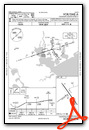
Instrument Approach Procedure (IAP) Charts


Nearby Airports with Instrument Procedures
| ID | Name | Heading / Distance | ||
|---|---|---|---|---|
 |
KVCT | Victoria Regional Airport | 314° | 17.3 |
|
26R | Jackson County Airport | 014° | 21.5 |
|
KPSX | Palacios Municipal Airport | 078° | 23.2 |
|
KRKP | Aransas County Airport | 209° | 38.9 |
|
KARM | Wharton Regional Airport | 037° | 45.5 |
|
T85 | Yoakum Municipal Airport | 328° | 46.2 |
|
KBYY | Bay City Regional Airport | 065° | 47.2 |
|
KTFP | Ingleside Regional Airport | 212° | 52.4 |
|
TX2 | Chase Field Industrial Airport | 251° | 54.6 |
|
KRAS | Mustang Beach Airport | 203° | 54.8 |
|
T69 | Sinton Airport | 231° | 58.5 |
|
KELA | Eagle Lake Airport | 018° | 59.7 |
Airport Images
Do you have a recent image of this airport? Upload it here!


