Login
Register


WYS
Yellowstone Airport
Official FAA Data Effective 2026-02-19 0901Z
Chart Supplement

VFR Chart of KWYS
Sectional Charts at SkyVector.com
IFR Chart of KWYS
Enroute Charts at SkyVector.com
Location Information for KWYS
Coordinates: N44°41.30' / W111°7.06'Located 01 miles N of West Yellowstone, Montana on 735 acres of land. View all Airports in Montana.
Surveyed Elevation is 6649 feet MSL.
Operations Data
|
|
Airport Communications
| AWOS-3P: | 118.1 Tel. (406) 646-7727 |
|---|---|
| CTAF: | 123.000 |
| UNICOM: | 123.000 |
| AWOS-3P at EKS (41.6 NW): | 119.85 406-682-3835 |
| AWOS-3PT at DIJ (56.8 S): | 120.775 208-354-6661 |
| ASOS at RXE (59.3 SW): | 135.075 208-356-0986 |
- APCH/DEP CTL SVC PRVDD BY SALT LAKE ARTCC (ZLC) ON FREQS 132.4/338.3 (BOZEMAN RCAG).
Nearby Navigation Aids
|
| ||||||||||||||||||||||||||||||||||||||||||


Runway 01/19
| Dimensions: | 8400 x 150 feet / 2560 x 46 meters | |
|---|---|---|
| Surface: | Asphalt / Grooved in Good Condition | |
| Weight Limits: | S-90, D-150, ST-280
PCR VALUE: 1490/F/A/X/T
| |
| Edge Lighting: | High Intensity | |
| Runway 01 | Runway 19 | |
| Coordinates: | N44°40.68' / W111°7.49' | N44°41.92' / W111°6.63' |
| Elevation: | 6648.8 | 6634.2 |
| Traffic Pattern: | Left | Left |
| Runway Heading: | 26° True | 206° True |
| Declared Distances: | TORA:8400 TODA:8400 ASDA:8400 LDA:8400 | TORA:8400 TODA:8400 ASDA:8400 LDA:8400 |
| Markings: | Precision Instrument in good condition. | Non-Precision Instrument in good condition. |
| Glide Slope Indicator | P4L (3.00° Glide Path Angle) | P4L (3.00° Glide Path Angle) |
| Approach Lights: | MALSR 1,400 Foot Medium-intensity Approach Lighting System with runway alignment indicator lights. | |
| REIL: | Yes | |
Services Available
| Fuel: | 100LL (blue), Jet A-1+ |
|---|---|
| Transient Storage: | Tiedowns |
| Airframe Repair: | NOT AVAILABLE |
| Engine Repair: | NOT AVAILABLE |
| Bottled Oxygen: | NOT AVAILABLE |
| Bulk Oxygen: | NOT AVAILABLE |
Ownership Information
| Ownership: | Publicly owned | |
|---|---|---|
| Owner: | STATE OF MONTANA | |
| PO BOX 200507 | ||
| HELENA, MT 59620 | ||
| 406-444-2506 | ||
| Manager: | JEFF KADLEC | |
| 721 AIRPORT RD., P.O. BOX 306 | ||
| WEST YELLOWSTONE, MT 59758-0306 | ||
| 406-646-7631 | 406-459-9825/406-444-2506. | |
Other Remarks
- THIS AIRPORT HAS BEEN SURVEYED BY THE NATIONAL GEODETIC SURVEY.
- SNOW REMOVAL NA. WINTER SNOWMOBILE ACT ON & INVOF OF ARPT.
- CLSD 31 OCT - 01 MAY; CK NOTAMS - AMGR OR 406-459-9825
- COLD TEMPERATURE AIRPORT. ALTITUDE CORRECTION REQUIRED AT OR BELOW -19C.
- COND UNMNT 1700-0800.
- FOR CD CTC SALT LAKE ARTCC AT 801-320-2568 .
- 0LL OFF SEASON FUEL- 406-646-7359.
- ACTVT MALSR RWY 01; REIL RWY 19; HIRL RWY 01/19 - CTAF. PAPI RWY 01 & 19 OPR CONSLY. NOT AVBL 31 OCT- 7 MAY .
Weather Minimums

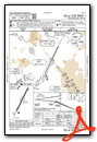
Instrument Approach Procedure (IAP) Charts


Departure Procedure Obstacles (DPO) Charts

Nearby Airports with Instrument Procedures
| ID | Name | Heading / Distance | ||
|---|---|---|---|---|
 |
KEKS | Ennis Big Sky Airport | 327° | 41.9 |
|
KDIJ | Driggs/Reed Memorial Airport | 179° | 56.7 |
|
KRXE | Rexburg-Madison County Airport | 210° | 59.2 |
|
KBZN | Bozeman Yellowstone International Airport | 358° | 65.4 |
|
KJAC | Jackson Hole Airport | 165° | 66.9 |
|
KLVM | Mission Field Airport | 024° | 67.0 |
|
KDLN | Dillon Airport | 299° | 69.9 |
|
KRVF | Ruby Valley Field Airport | 315° | 71.5 |
|
KIDA | Idaho Falls Regional Airport | 210° | 81.6 |
|
6S0 | Big Timber At Howard Field Airport | 035° | 82.7 |
|
KCOD | Yellowstone Regional Airport | 095° | 90.3 |
|
KDUB | Dubois Municipal Airport | 137° | 92.1 |
Airport Images

By: dpk1nba

By: vbazillio


