Login
Register


C25
Waverly Municipal Airport
Official FAA Data Effective 2026-02-19 0901Z
Chart Supplement

VFR Chart of C25
Sectional Charts at SkyVector.com
IFR Chart of C25
Enroute Charts at SkyVector.com
Location Information for C25
Coordinates: N42°44.51' / W92°30.43'Located 02 miles NW of Waverly, Iowa on 48 acres of land. View all Airports in Iowa.
Surveyed Elevation is 992 feet MSL.
Operations Data
|
|
Airport Communications
| DES MOINES APPROACH: | 118.9 251.15 |
|---|---|
| DES MOINES DEPARTURE: | 118.9 251.15 |
| CTAF: | 122.800 |
| UNICOM: | 122.800 |
| ATIS at ALO (12.0 SE): | 120.65 |
| ASOS at ALO (12.1 SE): | 120.65 319-209-4125 |
| AWOS-3 at CCY (20.4 N): | 125.525 641-228-7069 |
- APCH/DEP SVC PRVDD BY MINNEAPOLIS ARTCC ON FREQS 118.9/251.15 (REMOTED FROM WATERLOO RCAG) WHEN DES MOINES APCH CTL CLSD.
Nearby Navigation Aids
|
| ||||||||||||||||||||||||||||||||||||||||||||||||


Runway 11/29
| Dimensions: | 3200 x 60 feet / 975 x 18 meters | |
|---|---|---|
| Surface: | Concrete in Good Condition | |
| Weight Limits: | 5 /R/D/W/U, S-15, D-30 | |
| Edge Lighting: | Medium Intensity | |
| Runway 11 | Runway 29 | |
| Coordinates: | N42°44.59' / W92°30.77' | N42°44.43' / W92°30.09' |
| Elevation: | 992.3 | 980.0 |
| Traffic Pattern: | Left | Left |
| Runway Heading: | 107° True | 287° True |
| Markings: | Non-Precision Instrument in good condition. | Non-Precision Instrument in good condition. |
| Glide Slope Indicator | P2L (3.00° Glide Path Angle) | P2L (3.00° Glide Path Angle) |
| REIL: | Yes | Yes |
Services Available
| Fuel: | 100LL (blue) |
|---|---|
| Transient Storage: | Hangars,Tiedowns |
| Airframe Repair: | MAJOR |
| Engine Repair: | MAJOR |
| Bottled Oxygen: | HIGH/LOW |
| Bulk Oxygen: | NONE |
| Other Services: | PILOT INSTRUCTION,AIRCRAFT RENTAL |
Ownership Information
| Ownership: | Publicly owned | |
|---|---|---|
| Owner: | CITY OF WAVERLY | MIKE CHERRY - PUBLIC WORKS DEPT. |
| 200 2ST STREET NE | ||
| WAVERLY, IA 50677 | ||
| 319-352-4252 | ||
| Manager: | IRVIN SWIETER | |
| 1710 35TH ST NW | ||
| WAVERLY, IA 50677 | ||
| 319-352-8862 | ||
Other Remarks
- RY 11 PLINES L & R ON APCH. PLINE R ON APCH MKD WITH BALL MARKERS.
- FOR CD CTC DES MOINES APCH AT 515-974-8016. WHEN DES MOINES APCH CLSD, FOR CD CTC MINNEAPOLIS ARTCC AT 651-463-5588.
- ACTVT REIL RWY 11 AND 29; PAPI RWY 11 AND 29; MIRL RWY 11/29 - CTAF.
Weather Minimums

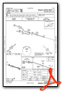
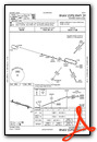
Instrument Approach Procedure (IAP) Charts
Nearby Airports with Instrument Procedures
| ID | Name | Heading / Distance | ||
|---|---|---|---|---|
 |
KALO | Waterloo Regional Airport | 156° | 12.0 |
|
KCCY | Northeast Iowa Regional Airport | 347° | 20.4 |
|
KOLZ | Oelwein Municipal Airport | 098° | 23.8 |
|
KIIB | James H Connell Field At Independence Municipal Airport | 124° | 30.1 |
|
KHPT | Hampton Municipal Airport | 268° | 31.8 |
|
3Y2 | George L Scott Municipal Airport | 064° | 34.8 |
|
KIFA | Iowa Falls Municipal Airport | 244° | 37.5 |
|
KVTI | Vinton Veterans Memorial Airpark Airport | 145° | 38.0 |
|
KCJJ | Ellen Church Field Airport | 023° | 40.9 |
|
KMIW | Marshalltown Municipal Airport | 205° | 41.9 |
|
KMCW | Mason City Municipal Airport | 304° | 44.1 |
|
KDEH | Decorah Municipal Airport | 046° | 46.6 |
Airport Images
Do you have a recent image of this airport? Upload it here!


