Login
Register


IFA
Iowa Falls Municipal Airport
Official FAA Data Effective 2025-12-25 0901Z
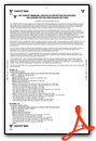
Chart Supplement

VFR Chart of KIFA
Sectional Charts at SkyVector.com
IFR Chart of KIFA
Enroute Charts at SkyVector.com
Location Information for KIFA
Coordinates: N42°28.28' / W93°16.24'Located 03 miles S of Iowa Falls, Iowa on 214 acres of land. View all Airports in Iowa.
Surveyed Elevation is 1137 feet MSL.
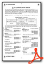
Operations Data
|
|
Airport Communications
| AWOS-3: | 120.425 Tel. 641-648-2469 |
|---|---|
| DES MOINES APPROACH: | 118.9 251.15 |
| DES MOINES DEPARTURE: | 118.9 251.15 |
| UNICOM: | 122.800 |
| CTAF: | 122.800 |
| AWOS-3 at HPT (15.3 N): | 121.025 641-456-4055 |
| AWOS-3 at EBS (26.6 W): | 127.825 515-832-2794 |
| ASOS at MIW (26.6 SE): | 128.325 641-752-2339 |
- APCH/DEP SVC PRVDD BY MINNEAPOLIS ARTCC ON FREQS 118.9/251.15 (REMOTED FROM WATERLOO) WHEN DES MOINES APCH CTL CLSD.
Nearby Navigation Aids
|
| ||||||||||||||||||||||||||||||||||||||||||


Runway 13/31
| Dimensions: | 4602 x 75 feet / 1403 x 23 meters | |
|---|---|---|
| Surface: | Concrete in Excellent Condition | |
| Weight Limits: | 16 /F/B/X/T, S-47, D-69 | |
| Edge Lighting: | Medium Intensity | |
| Runway 13 | Runway 31 | |
| Coordinates: | N42°28.55' / W93°16.60' | N42°28.01' / W93°15.88' |
| Elevation: | 1129.6 | 1137.3 |
| Traffic Pattern: | Left | Left |
| Runway Heading: | 135° True | 315° True |
| Markings: | Non-Precision Instrument in good condition. | Non-Precision Instrument in good condition. |
| Glide Slope Indicator | P2L (3.00° Glide Path Angle) | P2L (3.00° Glide Path Angle) |
| REIL: | Yes | Yes |
Services Available
| Fuel: | 100LL (blue), Jet A+ |
|---|---|
| Transient Storage: | Hangars,Tiedowns |
| Airframe Repair: | NONE |
| Engine Repair: | NONE |
| Bottled Oxygen: | NONE |
| Bulk Oxygen: | NONE |
| Other Services: | CROP DUSTING SERVICES |
Ownership Information
| Ownership: | Publicly owned | |
|---|---|---|
| Owner: | CITY OF IOWA FALLS | |
| PO BOX 698 | ||
| IOWA FALLS, IA 50126 | ||
| 641-648-2527 | ||
| Manager: | RENA HEEM | |
| 16041 HWY 65 | ||
| IOWA FALLS, IA 50126-8443 | ||
| 515-290-5450 | ||
Other Remarks
- RY 31 IS CALM WIND RY.
- FOR CD CTC DES MOINES APCH AT 515-974-8016. WHEN DES MOINES APP CLSD, FOR CD CTC MINNEAPOLIS ARTCC AT 651-463-5588.
- 0LL 24 HOUR SELF SERVE FUEL AVAILABLE
- ACTVT MIRL RY 13/31; REIL & PAPI RYS 13 & 31 - CTAF.
Weather Minimums
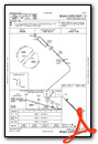
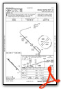
Instrument Approach Procedure (IAP) Charts
Nearby Airports with Instrument Procedures
| ID | Name | Heading / Distance | ||
|---|---|---|---|---|
 |
KHPT | Hampton Municipal Airport | 007° | 15.3 |
|
KEBS | Webster City Municipal Airport | 265° | 26.7 |
|
KMIW | Marshalltown Municipal Airport | 143° | 26.6 |
|
KCAV | Clarion Municipal Airport | 306° | 27.0 |
|
KEAG | Eagle Grove Municipal Airport | 296° | 32.0 |
|
KAMW | Ames Municipal Airport | 208° | 32.7 |
|
KBNW | Boone Municipal Airport | 225° | 36.1 |
|
C25 | Waverly Municipal Airport | 064° | 37.5 |
|
KALO | Waterloo Regional Airport | 081° | 38.9 |
|
KFOD | Fort Dodge Regional Airport | 276° | 41.2 |
|
KMCW | Mason City Municipal Airport | 356° | 41.3 |
|
KCCY | Northeast Iowa Regional Airport | 038° | 46.4 |
Airport Images
Do you have a recent image of this airport? Upload it here!


