Login
Register


CJJ
Ellen Church Field Airport
Official FAA Data Effective 2026-01-22 0901Z
Chart Supplement

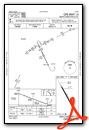
VFR Chart of KCJJ
Sectional Charts at SkyVector.com
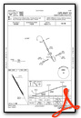
IFR Chart of KCJJ
Enroute Charts at SkyVector.com
Location Information for KCJJ
Coordinates: N43°21.92' / W92°7.98'Located 01 miles SW of Cresco, Iowa on 125 acres of land. View all Airports in Iowa.
Surveyed Elevation is 1279 feet MSL.
Operations Data
|
|
Airport Communications
| UNICOM: | 122.800 |
|---|---|
| CTAF: | 122.800 |
| AWOS-3 at DEH (18.0 E): | 120.925 563-382-2990 |
| AWOS-3PT at FKA (18.9 N): | 118.550 507-765-2182 |
| AWOS-3 at CCY (27.3 SW): | 125.525 641-228-7069 |
- APCH/DEP SVC PRVDD BY MINNAEPOLIS ARTCC ON FREQ 118.85 (LA CROSSE RCAG).
Nearby Navigation Aids
|
| ||||||||||||||||||||||||||||||||||||


Runway 15/33
| Dimensions: | 2949 x 50 feet / 899 x 15 meters | |
|---|---|---|
| Surface: | Concrete in Fair Condition | |
| Weight Limits: | S-29 | |
| Edge Lighting: | Low Intensity | |
| Runway 15 | Runway 33 | |
| Coordinates: | N43°22.14' / W92°8.13' | N43°21.70' / W92°7.84' |
| Elevation: | 1279.0 | 1265.0 |
| Traffic Pattern: | Left | Left |
| Runway Heading: | 154° True | 334° True |
| Markings: | Non-Precision Instrument in fair condition. | Non-Precision Instrument in fair condition. |
| Obstacles: | 74 ft Tree 1736 ft from runway, 86 ft left of center | 25 ft Pole 714 ft from runway, 228 ft left of center |
Services Available
| Fuel: | NONE |
|---|---|
| Transient Storage: | Tiedowns |
| Airframe Repair: | NONE |
| Engine Repair: | NONE |
| Bottled Oxygen: | NONE |
| Bulk Oxygen: | NONE |
Ownership Information
| Ownership: | Publicly owned | |
|---|---|---|
| Owner: | CITY OF CRESCO | |
| 130 NORTH PARK PLACE | ||
| CRESCO, IA 52136 | ||
| 319-547-3101 | ||
| Manager: | CLAIR PECINOVSKY | |
| 12848 WELL ROAD | ||
| CRESCO, IA 52136 | ||
| 563-547-4898 | ||
Other Remarks
- THIS AIRPORT HAS BEEN SURVEYED BY THE NATIONAL GEODETIC SURVEY.
- BE ALERT FOR ULTRALIGHT ACTIVITY ON & INVOF ARPT.
- FOR CD CTC ROCHESTER APCH AT 507-424-8111. FOR CD WHEN ROCHESTER APCH IS CLOSED, CTC MINNEAPOLIS ARTCC AT 651-463-5588.
- SNOW REMOVAL DELAYED AT TIMES; CONFIRM RWY CONDITIONS PRIOR TO USE: CALL 563-547-4898 OR AMGR, 563-379-5898.
- ACTVT LIRL RWY 15/33 - 122.7.
- ANSWERED BY POLICE; NOT ON FIELD.
- CTAF/UNICOM OTS INDEFLY.
Weather Minimums

Instrument Approach Procedure (IAP) Charts
Nearby Airports with Instrument Procedures
| ID | Name | Heading / Distance | ||
|---|---|---|---|---|
 |
KDEH | Decorah Municipal Airport | 107° | 18.1 |
|
KFKA | Fillmore County Airport | 353° | 18.8 |
|
3Y2 | George L Scott Municipal Airport | 146° | 27.3 |
|
KCCY | Northeast Iowa Regional Airport | 230° | 27.3 |
|
55Y | Rushford Municipal/Robert W Bunke Field Airport | 025° | 30.1 |
|
KCHU | Houston County Airport | 063° | 30.8 |
|
KRST | Rochester International Airport | 333° | 36.3 |
|
KAUM | Austin Municipal Airport | 297° | 39.2 |
|
C25 | Waverly Municipal Airport | 203° | 40.9 |
|
KOLZ | Oelwein Municipal Airport | 170° | 41.6 |
|
KONA | Winona Municipal/Max Conrad Field Airport | 023° | 46.6 |
|
KPDC | Prairie Du Chien Municipal Airport | 114° | 48.9 |
Airport Images
Do you have a recent image of this airport? Upload it here!


