Login
Register


CHU
Houston County Airport
Official FAA Data Effective 2025-11-27 0901Z
Chart Supplement

VFR Chart of KCHU
Sectional Charts at SkyVector.com
IFR Chart of KCHU
Enroute Charts at SkyVector.com
Location Information for KCHU
Coordinates: N43°35.78' / W91°30.24'Located 03 miles S of Caledonia, Minnesota on 52 acres of land. View all Airports in Minnesota.
Surveyed Elevation is 1179 feet MSL.
Operations Data
|
|
Airport Communications
| CTAF: | 122.900 |
|---|---|
| ATIS at LSE (20.1 NE): | 124.95 |
| ASOS at LSE (20.2 NE): | 124.95 608-781-9067 |
| AWOS-3 at DEH (21.8 SW): | 120.925 563-382-2990 |
- APCH/DEP SVC PRVDD BY MINNEAPOLIS ARTCC ON FREQS 128.6/363.0 (LA CROSSE RCAG).
- COMMUNICATIONS PRVDD BY GREEN BAY RADIO ON FREQ 122.6 (LA CROSSE RCO).
Nearby Navigation Aids
|
| ||||||||||||||||||||||||||||||||||||||||||


Runway 13/31
| Dimensions: | 3499 x 77 feet / 1066 x 23 meters | |
|---|---|---|
| Surface: | Asphalt in Fair Condition | |
| Weight Limits: | S-10 | |
| Edge Lighting: | Medium Intensity | |
| Runway 13 | Runway 31 | |
| Coordinates: | N43°35.99' / W91°30.52' | N43°35.58' / W91°29.96' |
| Elevation: | 1175.0 | 1179.0 |
| Traffic Pattern: | Left | Left |
| Runway Heading: | 135° True | 315° True |
| Markings: | Non-Precision Instrument in good condition. | Non-Precision Instrument in good condition. |
Services Available
| Fuel: | 100LL (blue) |
|---|---|
| Transient Storage: | Tiedowns |
| Airframe Repair: | NONE |
| Engine Repair: | NONE |
| Bottled Oxygen: | NONE |
| Bulk Oxygen: | NONE |
Ownership Information
| Ownership: | Publicly owned | |
|---|---|---|
| Owner: | HOUSTON COUNTY | |
| 304 S MARSHALL ST | ||
| CALEDONIA, MN 55921-1389 | ||
| 507-725-5803 | ||
| Manager: | BRIAN POGODZINSKI | |
| 1124 E WASHINGTON ST | ||
| CALEDONIA, MN 55921-1623 | ||
| 507-725-3925 | ||
Other Remarks
- THIS AIRPORT HAS BEEN SURVEYED BY THE NATIONAL GEODETIC SURVEY.
- TURF TWY 25 FT WIDE
- TURF TWY UNEVEN
- FOR CD CTC MINNEAPOLIS ARTCC AT 651-463-5588.
- 0LL 24 HR CREDIT CARD SVC AVBL.
- MIRL RWY 13/31 PRESET LOW INTS SS-SR; TO INCR INTS & ACTVT MIRL RWY 13/31 - CTAF.
Weather Minimums

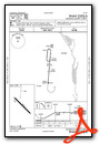
Instrument Approach Procedure (IAP) Charts

Nearby Airports with Instrument Procedures
| ID | Name | Heading / Distance | ||
|---|---|---|---|---|
 |
55Y | Rushford Municipal/Robert W Bunke Field Airport | 312° | 19.4 |
|
KLSE | La Crosse Regional Airport | 032° | 20.1 |
|
KDEH | Decorah Municipal Airport | 208° | 21.8 |
|
Y51 | Viroqua Municipal Airport | 091° | 26.5 |
|
KFKA | Fillmore County Airport | 279° | 29.8 |
|
KONA | Winona Municipal/Max Conrad Field Airport | 342° | 30.4 |
|
KCJJ | Ellen Church Field Airport | 243° | 30.8 |
|
KPDC | Prairie Du Chien Municipal Airport | 154° | 38.4 |
|
3Y2 | George L Scott Municipal Airport | 199° | 38.8 |
|
KCMY | Sparta/Fort Mc Coy Airport | 056° | 39.8 |
|
KOVS | Boscobel Airport | 125° | 44.7 |
|
KRST | Rochester International Airport | 293° | 47.2 |
Airport Images

By: Big Orange Bird


