Login
Register


RST
Rochester International Airport
Official FAA Data Effective 2026-02-19 0901Z
Chart Supplement

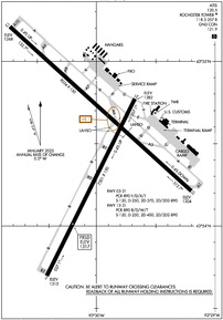
KRST Airport Diagram
VFR Chart of KRST
Sectional Charts at SkyVector.com
IFR Chart of KRST
Enroute Charts at SkyVector.com
Location Information for KRST
Coordinates: N43°54.50' / W92°30.00'Located 07 miles SW of Rochester, Minnesota on 2400 acres of land. View all Airports in Minnesota.
Surveyed Elevation is 1317 feet MSL.
Operations Data
|
|
Airport Communications
| ATIS: | 120.5 |
|---|---|
| ASOS: | Tel. 507-216-8425 |
| ROCHESTER TOWER: | 118.3 257.8 |
| ROCHESTER GROUND: | 121.9 |
| ROCHESTER APPROACH: | 119.8 251.125 |
| ROCHESTER DEPARTURE: | 119.8 251.125 |
| CTAF: | 118.300 |
| UNICOM: | 122.950 |
| EMERG: | 121.5 243.0 |
| AWOS-3PT at 9MN (6.7 N): | 124.175 507-255-9417 |
| AWOS-3PT at TOB (15.7 NW): | 119.075 507-374-6369 |
| AWOS-3PT at FKA (19.6 SE): | 118.550 507-765-2182 |
- APCH/DEP SVC PRVDD BY MINNEAPOLIS ARTCC ON FREQS 132.35/307.3 (ROCHESTER RCAG) WHEN ROCHESTER APCH CTL CLSD.
Nearby Navigation Aids
|
| ||||||||||||||||||||||||||||||||||||||||||||||||||||||


Runway 13/31
| Dimensions: | 9034 x 150 feet / 2754 x 46 meters | |
|---|---|---|
| Surface: | Concrete / Grooved in Good Condition | |
| Weight Limits: | S-120, D-250, ST-400, DT-890
PCR VALUE: 890/R/D/W/T
| |
| Edge Lighting: | High Intensity | |
| Runway 13 | Runway 31 | |
| Coordinates: | N43°55.21' / W92°30.73' | N43°54.21' / W92°29.20' |
| Elevation: | 1268.3 | 1304.1 |
| Traffic Pattern: | Left | Left |
| Runway Heading: | 132° True | 312° True |
| Declared Distances: | TORA:9033 TODA:9033 ASDA:9033 LDA:9033 | TORA:9033 TODA:9033 ASDA:9033 LDA:9033 |
| Markings: | Precision Instrument in good condition. | Precision Instrument in good condition. |
| Glide Slope Indicator | P4L (3.00° Glide Path Angle) | P4L (3.00° Glide Path Angle) |
| RVR Equipment |
Touchdown
Midfield
Rollout
RVR UNAVBL WHEN ATCT CLSD.
|
Touchdown
Midfield
Rollout
RVR UNAVBL WHEN ATCT CLSD.
|
| Approach Lights: | MALSR 1,400 Foot Medium-intensity Approach Lighting System with runway alignment indicator lights. | ALSF2 Standard 2,400 Foot High-intensity Approach Lighting System with sequenced flashers, CATEGORY II or III Configuration. |
| Centerline Lights: | Yes | Yes |
Runway 03/21
| Dimensions: | 7301 x 150 feet / 2225 x 46 meters | |
|---|---|---|
| Surface: | Asphalt-Concrete / Grooved in Good Condition RWY 03 END 2075 FT CONC, MID 3777 FT ASPHALT, RWY 21 END 1449 FT CONC. | |
| Weight Limits: | S-120, D-250, ST-370, DT-890
PCR VALUE: 890/F/D/X/T
| |
| Edge Lighting: | Medium Intensity | |
| Runway 03 | Runway 21 | |
| Coordinates: | N43°53.70' / W92°30.42' | N43°54.77' / W92°29.67' |
| Elevation: | 1314.6 | 1282.0 |
| Traffic Pattern: | Left | Left |
| Runway Heading: | 26° True | 206° True |
| Declared Distances: | TORA:7300 TODA:7300 ASDA:7300 LDA:7300 | TORA:7300 TODA:7300 ASDA:7300 LDA:7300 |
| Markings: | Non-Precision Instrument in good condition. | Non-Precision Instrument in good condition. |
| Glide Slope Indicator | V4L (3.00° Glide Path Angle) | P4L (3.05° Glide Path Angle) |
| REIL: | Yes | Yes |
Services Available
| Fuel: | 100LL (blue), Jet-A |
|---|---|
| Transient Storage: | Hangars |
| Airframe Repair: | MAJOR |
| Engine Repair: | MAJOR |
| Bottled Oxygen: | HIGH/LOW |
| Bulk Oxygen: | NONE |
| Other Services: | CHARTER SERVICE,PILOT INSTRUCTION,AIRCRAFT RENTAL |
Ownership Information
| Ownership: | Publicly owned | |
|---|---|---|
| Owner: | CITY OF ROCHESTER | |
| CITY HALL, 201 4TH ST SE | ||
| ROCHESTER, MN 55904-3708 | ||
| 507-254-1161 | ||
| Manager: | JOHN C REED | |
| 7600 HELGERSON DR SW | ||
| ROCHESTER, MN 55902-1838 | ||
| 507-254-1161 | ||
Other Remarks
- WHEN ATCT CLSD SNOW REMOVAL EQPT PSNL MNT CTAF.
- WATERFOWL ON & INVOF ARPT.
- US CUST AVBL MON-FRI 0830-1700; PN AFT HRS & WKENDS CALL 507-285-5278.
- FOR CD WHEN ATCT IS CLSD CTC FSS VIA RCO, IF UNA CTC MINNEAPOLIS ARTCC AT 651-463-5588.
- 0LL AVBL 24 HRS WITH CREDIT CARD.
- WHEN ATCT CLSD ACTVT OR INCR INTST MALSR RWY 13; HIRL RWY 13/31; MIRL RWY 03/21 - CTAF. HIRL RWY 13/31 PRESET LOW INTST. PAPI RWY 13, 21, & 31; VASI RWY 03 - OPR CONSLY.
Weather Minimums


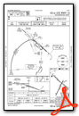
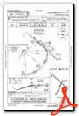
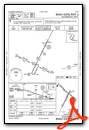
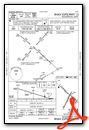
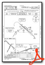
Instrument Approach Procedure (IAP) Charts


Nearby Airports with Instrument Procedures
| ID | Name | Heading / Distance | ||
|---|---|---|---|---|
 |
KTOB | Dodge Center Airport | 294° | 15.8 |
|
KFKA | Fillmore County Airport | 134° | 19.7 |
|
KAUM | Austin Municipal Airport | 232° | 23.9 |
|
55Y | Rushford Municipal/Robert W Bunke Field Airport | 100° | 29.6 |
|
KOWA | Owatonna Degner Regional Airport | 291° | 35.3 |
|
KONA | Winona Municipal/Max Conrad Field Airport | 072° | 35.7 |
|
KCJJ | Ellen Church Field Airport | 153° | 36.3 |
|
KAEL | Albert Lea Municipal Airport | 250° | 40.1 |
|
KRGK | Red Wing Regional Airport | 000° | 40.9 |
|
KFBL | Faribault Municipal-Liz Wall Strohfus Field Airport | 305° | 43.3 |
|
KACQ | Waseca Municipal/Maynard Richard Stensrud Field Airport | 282° | 46.7 |
|
KCHU | Houston County Airport | 113° | 47.2 |
Airport Images

By: Dave


