Login
Register


CKM
Fletcher Field Airport
Official FAA Data Effective 2026-01-22 0901Z
Chart Supplement

VFR Chart of KCKM
Sectional Charts at SkyVector.com
IFR Chart of KCKM
Enroute Charts at SkyVector.com
Location Information for KCKM
Coordinates: N34°17.98' / W90°30.74'Located 07 miles NE of Clarksdale, Mississippi on 252 acres of land. View all Airports in Mississippi.
Surveyed Elevation is 173 feet MSL.
Operations Data
|
|
Airport Communications
| AWOS-3: | 120.675 Tel. 662-624-9777 |
|---|---|
| CTAF: | 122.800 |
| UNICOM: | 122.800 |
| AWOS-3 at UTA (24.5 N): | 118.075 662-363-1652 |
| AWOS-3PT at PMU (31.0 E): | 118.225 662-563-6267 |
| AWOS-3PT at RNV (34.6 S): | 124.175 662-843-3021 |
- APCH/DEP SVC PRVDD BY MEMPHIS ARTCC ON FREQS 135.3/335.8 (BRINKLEY RCAG).
Nearby Navigation Aids
|
| ||||||||||||||||||||||||||||||||||||||||||||||||||||||||||||


Runway 18/36
1 HR PPR FOR ACFT OVER 30000 LBS, CALL 662-624-5554 OR 662-902-1893. | ||
| Dimensions: | 5404 x 100 feet / 1647 x 30 meters | |
|---|---|---|
| Surface: | Asphalt / Grooved in Excellent Condition | |
| Weight Limits: | 30 /F/A/W/T, S-25, D-32 | |
| Edge Lighting: | Medium Intensity | |
| Runway 18 | Runway 36 | |
| Coordinates: | N34°18.43' / W90°30.71' | N34°17.54' / W90°30.76' |
| Elevation: | 171.5 | 172.5 |
| Traffic Pattern: | Left | Left |
| Runway Heading: | 183° True | 3° True |
| Markings: | Non-Precision Instrument in fair condition. | Non-Precision Instrument in fair condition. |
| Glide Slope Indicator | P4R (3.00° Glide Path Angle) | P4L (3.00° Glide Path Angle) |
| REIL: | Yes | Yes |
| Obstacles: | 95 ft Trees 2240 ft from runway, 200 ft right of center | |
Services Available
| Fuel: | 100LL (blue), Jet-A |
|---|---|
| Transient Storage: | Hangars,Tiedowns PILOTS MUST PRVD THEIR OWN TIEDOWN ROPES. |
| Airframe Repair: | NOT AVAILABLE |
| Engine Repair: | MINOR |
| Bottled Oxygen: | NONE |
| Bulk Oxygen: | NONE |
| Other Services: | CROP DUSTING SERVICES,PILOT INSTRUCTION,AIRCRAFT RENTAL |
Ownership Information
| Ownership: | Publicly owned | |
|---|---|---|
| Owner: | COAHOMA CO ARPT BOARD | AND CITY OF CLARKSDALE. |
| PO BOX 406 | ||
| CLARKSDALE, MS 38614 | ||
| 662-624-5554 | ||
| Manager: | DAVID HUGGINS | |
| PO BOX 700 | ||
| CLARKSDALE, MS 38614 | ||
| 662-627-4126 | ||
Other Remarks
- NMRS AGRICULTURAL ACFT OPS W OF N/S TWY. ACFT DEP N & LAND S.
- TWY LGTS ON S STUB TWY TO APN.
- FOR CD CTC MEMPHIS ARTCC AT 901-368-8453/8449.
- 0LL FUEL AVBL 24 HRS WITH CREDIT CARD. OTS INDEF.
- ACTVT REIL RWY 18 & 36; MIRL RWY 18/36 - CTAF. PAPI RWY 18 & 36 OPR CONSLY.
Weather Minimums
Instrument Approach Procedure (IAP) Charts
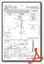
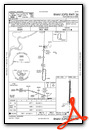
Nearby Airports with Instrument Procedures
| ID | Name | Heading / Distance | ||
|---|---|---|---|---|
 |
KMMS | Selfs Airport | 110° | 11.8 |
|
KHEE | Thompson-Robbins Airport | 333° | 18.5 |
|
KUTA | Tunica Municipal Airport | 019° | 24.5 |
|
KPMU | Panola County Airport | 082° | 31.0 |
|
M37 | Ruleville-Drew Airport | 181° | 31.4 |
|
6M7 | Marianna/Lee County-Steve Edwards Field Airport | 333° | 32.5 |
|
KRNV | Cleveland Municipal Airport | 200° | 34.4 |
|
5M1 | Dewitt Municipal/Whitcomb Field Airport | 266° | 39.6 |
|
KGNF | Grenada Municipal Airport | 127° | 45.3 |
|
M73 | Almyra Municipal Airport | 278° | 47.8 |
|
M36 | Frank Federer Memorial Airport | 316° | 47.9 |
|
KUOX | University-Oxford Airport | 083° | 48.7 |
Airport Images
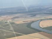
By: Big Orange Bird

By: jtrolinger


Comments
Location
The FBO is on the North end of the airport. The South end terminal is a movie set.