



Login
Register
8A1
Guntersville Municipal/Joe Starnes Field Airport
Official FAA Data Effective 2026-10-29 0901Z
Chart Supplement

VFR Chart of 8A1
Sectional Charts at SkyVector.com
IFR Chart of 8A1
Enroute Charts at SkyVector.com
Location Information for 8A1
Coordinates: N34°24.37' / W86°15.65'Located 03 miles NE of Guntersville, Alabama on 15 acres of land. View all Airports in Alabama.
Surveyed Elevation is 614 feet MSL.
Operations Data
|
|
Airport Communications
| AWOS-3PT: | 121.125 |
|---|---|
| HUNTSVILLE APPROACH: | 125.6 354.1 |
| HUNTSVILLE DEPARTURE: | 125.6 354.1 |
| CTAF: | 122.800 |
| UNICOM: | 122.800 |
| AWOS-3PT at BFZ (10.5 S): | 119.575 256-891-8259 |
| AWOS-3PT at 4A6 (21.1 NE): | 120.125 256-259-1148 |
| ATIS at HUA (26.6 NW): | 120.65 |
- APCH/DEP SVC PRVDD BY MEMPHIS ARTCC ON FREQS 120.8/307.0 (HUNTSVILLE RCAG) WHEN HUNTSVILLE APCH CTL CLSD.
Nearby Navigation Aids
|
| ||||||||||||||||||||||||||||||||||||||||||||||||||||||||||||


Runway 06W/24W
| Dimensions: | 5500 x 200 feet / 1676 x 61 meters | |
|---|---|---|
| Surface: | Water | |
| Runway 06W | Runway 24W | |
| Coordinates: | N34°24.35' / W86°16.00' | N34°24.73' / W86°15.01' |
| Elevation: | 595.0 | 595.0 |
| Runway Heading: | 65° True | 245° True |
Runway 07/25
| Dimensions: | 5005 x 75 feet / 1526 x 23 meters | |
|---|---|---|
| Surface: | Asphalt / Grooved in Good Condition | |
| Weight Limits: | S-24 | |
| Edge Lighting: | Medium Intensity | |
| Runway 07 | Runway 25 | |
| Coordinates: | N34°24.01' / W86°16.27' | N34°24.36' / W86°15.36' |
| Elevation: | 610.0 | 614.6 |
| Runway Heading: | 65° True | 245° True |
| Markings: | Non-Precision Instrument in good condition. | Non-Precision Instrument in good condition. |
| Glide Slope Indicator | P2L (3.35° Glide Path Angle) | |
| REIL: | Yes | Yes |
| Obstacles: | 19 ft Power Line 652 ft from runway, 306 ft left of center | 19 ft Trees 261 ft from runway, 153 ft right of center |
Services Available
| Fuel: | 100LL (blue), Jet A+ |
|---|---|
| Transient Storage: | Tiedowns |
| Airframe Repair: | MAJOR |
| Engine Repair: | MAJOR |
| Bottled Oxygen: | NONE |
| Bulk Oxygen: | NONE |
| Other Services: | AIRCRAFT RENTAL |
Ownership Information
| Ownership: | Publicly owned | |
|---|---|---|
| Owner: | CITY OF GUNTERSVILLE | |
| 341 GUNTER AVE | ||
| GUNTERSVILLE, AL 35976-1128 | ||
| 256-571-7560 | ||
| Manager: | GARY MCILQUHAM | |
| 405 BUCK ISLAND RD | ||
| GUNTERSVILLE, AL 35976-8453 | ||
| (256) 582-6087 | ||
Other Remarks
- DEER, BIRDS, AND COYOTES ON & INVOF ARPT.
- FOR CD CTC HUNTSVILLE APCH AT 256-542-2070, WHEN APCH CLSD CTC MEMPHIS ARTCC AT 901-368-8453/8449.
- CALL OUT SVC AVBL 256-582-6087.
- 0LL 24/7 SELF-SVC AVGAS & FULL SVC JET-A DURNG NML OPN HRS.
- ACTVT REIL RWY 7 & 25; PAPI RWY 25; MIRL RWY 7/25 - CTAF.
Weather Minimums


Instrument Approach Procedure (IAP) Charts


Nearby Airports with Instrument Procedures
| ID | Name | Heading / Distance | ||
|---|---|---|---|---|
 |
KBFZ | Albertville Regional/Thomas J Brumlik Field Airport | 178° | 10.6 |
|
4A6 | Scottsboro Municipal-Word Field Airport | 036° | 21.1 |
|
20A | Robbins Field Airport | 192° | 26.7 |
|
4A9 | Isbell Field Airport | 081° | 27.1 |
|
KGAD | Northeast Alabama Regional Airport | 162° | 27.4 |
|
KHSV | Huntsville International-Carl T Jones Field Airport | 298° | 29.0 |
|
KCMD | Cullman Regional/Folsom Field Airport | 254° | 30.8 |
|
KMDQ | Huntsville Exec Tom Sharp Jr Field Airport | 331° | 30.9 |
|
5M0 | Hartselle/Morgan County Regional Airport | 270° | 33.4 |
|
KDCU | Pryor Field Regional Airport | 293° | 37.0 |
|
KPYP | Centre Piedmont/Cherokee County Regional Airport | 120° | 37.5 |
|
KFYM | Fayetteville Municipal Airport | 339° | 41.9 |
Airport Images

By: anonymous
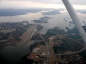
By: GCA7SKY



Comments
Runway Markings have been