Login
Register


HSV
Huntsville International-Carl T Jones Field Airport
Official FAA Data Effective 2025-11-27 0901Z
From the Flight Deck
Chart Supplement

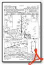
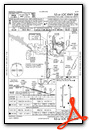
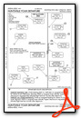
KHSV Airport Diagram

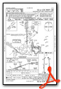
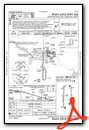
VFR Chart of KHSV
Sectional Charts at SkyVector.com
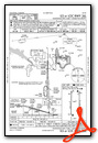
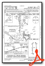
IFR Chart of KHSV
Enroute Charts at SkyVector.com
Location Information for KHSV
Coordinates: N34°38.23' / W86°46.50'Located 09 miles SW of Huntsville, Alabama on 6000 acres of land. View all Airports in Alabama.
Surveyed Elevation is 628 feet MSL.
Operations Data
|
|
Airport Communications
| ATIS: | 121.25 |
|---|---|
| ASOS: | 121.25 Tel. 256-207-5925 |
| HUNTSVILLE TOWER: | 127.6 350.35 |
| HUNTSVILLE GROUND: | 121.9 269.525 |
| HUNTSVILLE APPROACH: | 118.05 ;185-004 118.75 125.6 ;005-184 239.0 ;185-004 354.1 ;005-184 |
| HUNTSVILLE DEPARTURE: | 118.05 ;185-004 125.6 ;005-184 239.0 ;185-004 354.1 ;005-184 |
| IC: | 125.6 ;005-184 354.1 ;005-184 |
| CLEARANCE DELIVERY: | 120.35 |
| UNICOM: | 122.950 |
| EMERG: | 121.5 243.0 |
| CTAF: | 127.600 |
| CLASS C: | 118.05 ;185-004 125.6 ;005-184 239.0 ;185-004 354.1 ;005-184 |
| ATIS at HUA (5.1 NE): | 120.65 |
| ASOS at DCU (8.5 W): | 118.375 256-350-4270 |
| AWOS-3PT at MDQ (17.1 NE): | 120.000 256-829-1242 |
- APCH/DEP SVC PRVDD BY MEMPHIS ARTCC ON FREQS 120.8/307.0 (HUNTSVILLE RCAG) WHEN HUNTSVILLE APCH CTL CLSD.
Nearby Navigation Aids
|
| ||||||||||||||||||||||||||||||||||||||||||||||||||||||


Runway 18R/36L
| Dimensions: | 12600 x 150 feet / 3840 x 46 meters | |
|---|---|---|
| Surface: | Asphalt-Concrete / Grooved in Excellent Condition | |
| Weight Limits: | S-120, D-250, ST-550, DT-1114
PCR VALUE: 768/F/B/X/T
| |
| Edge Lighting: | High Intensity | |
| Runway 18R | Runway 36L | |
| Coordinates: | N34°39.17' / W86°46.93' | N34°37.09' / W86°46.97' |
| Elevation: | 628.4 | 611.2 |
| Traffic Pattern: | Right | Left |
| Runway Heading: | 181° True | 1° True |
| Declared Distances: | TORA:12600 TODA:12600 ASDA:12600 LDA:12600 | TORA:12600 TODA:12600 ASDA:12600 LDA:12600 |
| Markings: | Precision Instrument in good condition. | Precision Instrument in good condition. |
| RVR Equipment | Touchdown Midfield Rollout | Touchdown Midfield Rollout |
| Approach Lights: | ALSF2 Standard 2,400 Foot High-intensity Approach Lighting System with sequenced flashers, CATEGORY II or III Configuration. | MALSR 1,400 Foot Medium-intensity Approach Lighting System with runway alignment indicator lights. |
| Centerline Lights: | Yes | Yes |
Runway 18L/36R
| Dimensions: | 10001 x 150 feet / 3048 x 46 meters | |
|---|---|---|
| Surface: | Asphalt / Grooved in Excellent Condition | |
| Weight Limits: | S-120, D-247, ST-435, DT-972
PCR VALUE: 620/F/B/X/T
| |
| Edge Lighting: | High Intensity | |
| Runway 18L | Runway 36R | |
| Coordinates: | N34°39.19' / W86°45.93' | N34°37.54' / W86°45.96' |
| Elevation: | 609.3 | 588.6 |
| Traffic Pattern: | Left | Right |
| Runway Heading: | 181° True | 1° True |
| Displaced Threshold: | 200 Feet | |
| Declared Distances: | TORA:10001 TODA:10001 ASDA:9801 LDA:9801 | TORA:10001 TODA:10001 ASDA:10001 LDA:9801 |
| Markings: | Precision Instrument in good condition. | Precision Instrument in good condition. |
| Glide Slope Indicator | P4R (3.00° Glide Path Angle) | P4R (3.00° Glide Path Angle) |
| RVR Equipment | Touchdown Rollout | Touchdown Rollout |
| Approach Lights: | MALSR 1,400 Foot Medium-intensity Approach Lighting System with runway alignment indicator lights. | MALSR 1,400 Foot Medium-intensity Approach Lighting System with runway alignment indicator lights. |
Services Available
| Fuel: | 100LL (blue), Jet-A |
|---|---|
| Transient Storage: | Hangars,Tiedowns |
| Airframe Repair: | MAJOR |
| Engine Repair: | MAJOR |
| Bottled Oxygen: | HIGH/LOW |
| Bulk Oxygen: | HIGH/LOW |
| Other Services: | AIR FREIGHT SERVICES,AVIONICS,CARGO HANDLING SERVICES,CHARTER SERVICE,PILOT INSTRUCTION,AIRCRAFT RENTAL,ANNUAL SURVEYING |
Ownership Information
| Ownership: | Publicly owned | |
|---|---|---|
| Owner: | HUNTSVILLE MADISON COUNTY | AIRPORT AUTHORITY |
| 1000 GLENN HEARN BLVD, | ||
| HUNTSVILLE, AL 35824 | ||
| 256-772-9395 | ||
| Manager: | BUTCH ROBERTS | |
| 1000 GLENN HEARN BLVD,, BOX 20008 | ||
| HUNTSVILLE, AL 35824 | ||
| 256-258-1958 | ||
Other Remarks
- LINE UP AND WAIT NA.
- FOR CD WHEN TWR CLSD, IF UNA TO CTC ON FSS FREQ, CTC MEMPHIS ARTCC AT 901-368-8453/8449.
- FLT NOTIFICATION SVC (ADCUS) AVBL.
- INTXN OF TWY J AND SERVICE RD IS UNCONTROLLED.
- ACTVT MALSR RWY 18L, 36L & 36R; HIRL RWY 18L/36R & 18R/36L - CTAF. RWY 18R ALSF ON STEP 2 WHEN ATCT CLSD.
Weather Minimums


Instrument Approach Procedure (IAP) Charts

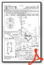

Departure Procedure (DP) Charts
Nearby Airports with Instrument Procedures
| ID | Name | Heading / Distance | ||
|---|---|---|---|---|
 |
KDCU | Pryor Field Regional Airport | 276° | 8.5 |
|
5M0 | Hartselle/Morgan County Regional Airport | 209° | 15.8 |
|
KMDQ | Huntsville Exec Tom Sharp Jr Field Airport | 038° | 17.1 |
|
KCMD | Cullman Regional/Folsom Field Airport | 190° | 22.5 |
|
KFYM | Fayetteville Municipal Airport | 022° | 27.4 |
|
9A4 | Courtland Airport | 272° | 28.4 |
|
8A1 | Guntersville Municipal/Joe Starnes Field Airport | 118° | 29.0 |
|
KGZS | Abernathy Field Airport | 335° | 33.9 |
|
KBFZ | Albertville Regional/Thomas J Brumlik Field Airport | 133° | 35.5 |
|
4A6 | Scottsboro Municipal-Word Field Airport | 085° | 38.2 |
|
KMSL | Northwest Alabama Regional Airport | 279° | 41.8 |
|
2M2 | Lawrenceburg/Lawrence County (Fleeman Field) Airport | 326° | 43.0 |
Airport Images

By: vahalla9@gmail.com


