Login
Register


CON
Concord Municipal Airport
Official FAA Data Effective 2026-01-22 0901Z
Chart Supplement

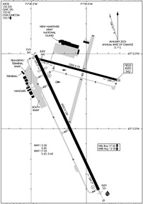
KCON Airport Diagram
VFR Chart of KCON
Sectional Charts at SkyVector.com
IFR Chart of KCON
Enroute Charts at SkyVector.com
Location Information for KCON
Coordinates: N43°12.16' / W71°30.14'Located 02 miles E of Concord, New Hampshire on 697 acres of land. View all Airports in New Hampshire.
Surveyed Elevation is 341 feet MSL.
Operations Data
|
|
Airport Communications
| ASOS: | 132.325 Tel. 603-451-1106 |
|---|---|
| BOSTON APPROACH: | 127.35 269.075 |
| BOSTON DEPARTURE: | 127.35 269.075 |
| CLEARANCE DELIVERY: | 133.65 |
| CTAF: | 122.700 |
| UNICOM: | 122.700 |
| ATIS at MHT (16.5 S): | 119.55 |
| ASOS at MHT (16.7 S): | 119.55 603-626-6902 |
| AWOS-3PT at LCI (22.5 N): | 133.525 603-524-5134 |
Nearby Navigation Aids
|
| ||||||||||||||||||||||||||||||||||||||||||||||||||||||||||||


Runway 17/35
| Dimensions: | 6005 x 100 feet / 1830 x 30 meters | |
|---|---|---|
| Surface: | Asphalt in Fair Condition | |
| Weight Limits: | S-43, D-60 | |
| Edge Lighting: | High Intensity | |
| Runway 17 | Runway 35 | |
| Coordinates: | N43°12.49' / W71°30.46' | N43°11.59' / W71°29.89' |
| Elevation: | 340.6 | 331.4 |
| Runway Heading: | 155° True | 335° True |
| Displaced Threshold: | 641 Feet | |
| Markings: | Non-Precision Instrument in good condition. | Precision Instrument in good condition. |
| Glide Slope Indicator | P4L (3.00° Glide Path Angle) | V4L (3.00° Glide Path Angle) |
| Approach Lights: | MALSR 1,400 Foot Medium-intensity Approach Lighting System with runway alignment indicator lights. | |
| Obstacles: | 68 ft Tree 858 ft from runway, 105 ft left of center APCH SLP 26:1 TO DTHR. |
64 ft Trees 662 ft from runway, 789 ft left of center |
Runway 12/30
| Dimensions: | 3200 x 75 feet / 975 x 23 meters | |
|---|---|---|
| Surface: | Asphalt in Good Condition | |
| Weight Limits: | S-30 | |
| Edge Lighting: | Medium Intensity | |
| Runway 12 | Runway 30 | |
| Coordinates: | N43°12.46' / W71°30.41' | N43°12.32' / W71°29.72' |
| Elevation: | 339.8 | 341.7 |
| Traffic Pattern: | Left | Left |
| Runway Heading: | 105° True | 285° True |
| Markings: | Non-Precision Instrument in good condition. | Non-Precision Instrument in good condition. |
| Obstacles: | 19 ft Antenna 220 ft from runway, 133 ft right of center | 13 ft Ground 293 ft from runway, 143 ft right of center 15 FT TREES 57 FT FM THR, 248 FT R. |
Services Available
| Fuel: | 100LL (blue), Jet-A |
|---|---|
| Transient Storage: | Hangars,Tiedowns |
| Airframe Repair: | MAJOR |
| Engine Repair: | MAJOR |
| Bottled Oxygen: | NONE |
| Bulk Oxygen: | NONE |
| Other Services: | AVIONICS,PILOT INSTRUCTION,AIRCRAFT RENTAL,AIRCRAFT SALES |
Ownership Information
| Ownership: | Publicly owned | |
|---|---|---|
| Owner: | CITY OF CONCORD | |
| 41 GREEN ST | CITY MGR OFC. | |
| CONCORD, NH 03301 | ||
| 603-225-8570 | ||
| Manager: | DAVID ROLLA | |
| 71 AIRPORT RD | ||
| CONCORD, NH 03301 | ||
| 603-228-2267 | ||
Other Remarks
- THIS AIRPORT HAS BEEN SURVEYED BY THE NATIONAL GEODETIC SURVEY.
- WILDLIFE ON & INVOF ARPT.
- COMPASS ROSE CALIBRATED 2014.
- FOR CD CTC BOSTON APCH AT 603-594-5552.
- OPS ON NG TWY & RAMP PROHIBITED WO PRIOR CDN DUE TO SCTY.
- DAY & NGT VFR HEL OPS TO & FM NEW HAMPSHIRE STATE POLICE HNGR.
- OPS OFF PAVED SFCS PROHIBITED DUE TO CONSERVATION MGMT ACTS.
- RWY 35 DSGND CALM WIND RWY.
- MIL TWY & RAMP PCN R/A/W/T.
- HVY HEL ACT 1 NM ESE OF ARPT 800 FT & BLW.
- 0LL SELF SVC 100LL AVBL 24 HRS WITH CREDIT CARD. FOR JET A AFT HRS CALL 603-228-2267 & FLW PROMPTS.
- ACTVT MALSR RWY 35; HIRL RWY 17/35; MIRL RWY 12/30 - CTAF.
Weather Minimums

Instrument Approach Procedure (IAP) Charts
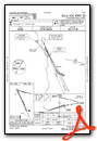
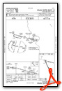
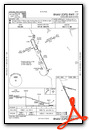
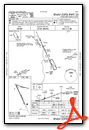
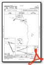
Nearby Airports with Instrument Procedures
| ID | Name | Heading / Distance | ||
|---|---|---|---|---|
 |
KMHT | Manchester Boston Regional Airport | 169° | 16.5 |
|
KLCI | Laconia Municipal Airport | 009° | 22.5 |
|
KASH | Boire Field Airport | 181° | 25.2 |
|
KDAW | Skyhaven Airport | 078° | 25.6 |
|
KPSM | Portsmouth International At Pease Airport | 103° | 30.8 |
|
2B3 | Parlin Field Airport | 290° | 32.0 |
|
KAFN | Jaffrey Airfield Silver Ranch Airport | 222° | 32.5 |
|
KLWM | Lawrence Municipal Airport | 150° | 33.6 |
|
KSFM | Sanford Seacoast Regional Airport | 071° | 36.6 |
|
KEEN | Dillant/Hopkins Airport | 241° | 38.4 |
|
KCNH | Claremont Municipal Airport | 285° | 39.3 |
|
KFIT | Fitchburg Municipal Airport | 196° | 40.5 |


