Login
Register


LCI
Laconia Municipal Airport
Official FAA Data Effective 2025-12-25 0901Z
Chart Supplement

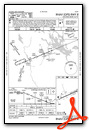
VFR Chart of KLCI
Sectional Charts at SkyVector.com
IFR Chart of KLCI
Enroute Charts at SkyVector.com
Location Information for KLCI
Coordinates: N43°34.38' / W71°25.07'Located 03 miles NE of Laconia, New Hampshire on 502 acres of land. View all Airports in New Hampshire.
Surveyed Elevation is 545 feet MSL.
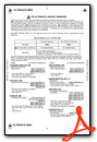
Operations Data
|
|
Airport Communications
| AWOS-3PT: | 133.525 Tel. 603-524-5134 |
|---|---|
| BOSTON APPROACH: | 134.75 254.25 |
| BOSTON DEPARTURE: | 134.75 254.25 |
| CLEARANCE DELIVERY: | 119.85 |
| CTAF: | 123.000 |
| UNICOM: | 123.000 |
| AWOS-3 at 1P1 (19.1 NW): | 118.45 603-536-1698 |
| ASOS at CON (22.4 S): | 132.325 603-451-1106 |
| ASOS at DAW (27.5 SE): | 135.275 603-332-7814 |
Nearby Navigation Aids
|
| ||||||||||||||||||||||||||||||||||||||||||||||||||||||||||||


Runway 08/26
| Dimensions: | 5890 x 100 feet / 1795 x 30 meters | |
|---|---|---|
| Surface: | Asphalt / Grooved in Good Condition | |
| Weight Limits: | 35 /F/D/X/T, S-85, D-110, ST-175 | |
| Edge Lighting: | High Intensity | |
| Runway 08 | Runway 26 | |
| Coordinates: | N43°34.20' / W71°25.69' | N43°34.57' / W71°24.45' |
| Elevation: | 545.4 | 515.5 |
| Traffic Pattern: | Left | Left |
| Runway Heading: | 68° True | 248° True |
| Displaced Threshold: | 244 Feet | |
| Declared Distances: | TORA:5890 TODA:5890 ASDA:5646 LDA:5646 | TORA:5890 TODA:5890 ASDA:5530 LDA:5286 |
| Markings: | Precision Instrument in fair condition. | Non-Precision Instrument in fair condition. |
| Glide Slope Indicator | P4L (3.00° Glide Path Angle) | P4R (4.00° Glide Path Angle) PAPI UNUSBL BYD 6 DEGS L OF CNTRLN. |
| Approach Lights: | MALSR 1,400 Foot Medium-intensity Approach Lighting System with runway alignment indicator lights. | |
| REIL: | Yes | |
| Obstacles: | 57 ft Trees 380 ft from runway, 380 ft right of center | 63 ft Trees 496 ft from runway, 479 ft right of center |
Services Available
| Fuel: | 100LL (blue), Jet-A, Jet A+ |
|---|---|
| Transient Storage: | Hangars,Tiedowns |
| Airframe Repair: | MAJOR |
| Engine Repair: | MAJOR |
| Bottled Oxygen: | HIGH/LOW |
| Bulk Oxygen: | HIGH/LOW |
| Other Services: | CHARTER SERVICE,PILOT INSTRUCTION,AIRCRAFT RENTAL,AIRCRAFT SALES |
Ownership Information
| Ownership: | Publicly owned | |
|---|---|---|
| Owner: | LACONIA AIRPORT AUTHORITY | |
| 65 AVIATION DR | ||
| GILFORD, NH 03429 | ||
| 603-524-5003 | ||
| Manager: | MARV EVERSON | |
| 65 AVIATION DR | ||
| GILFORD, NH 03429 | ||
| 603-524-5003 | ||
Other Remarks
- WILDLIFE ON & INVOF ARPT.
- TWY A CLSD TO ACFT WITH WINGSPANS GTR THAN 49 FT.
- FOR CD CTC BOSTON APCH AT 603-594-5552.
- CTN: LOCKE'S HILL 500 FT TRRN MKD WITH 2 RED BCNS, 1.2 NM E OF ARPT.
- CTN: RISING TRRN 5000 FT S OF ARPT.
- RWY 26 DSGND CALM WIND RWY.
- VOLUNTARY NOISE ABATEMENT PROC: AVOID OVERFLYING VARNEY POINT 1 NM NE OF ARPT. SEE LACONIA ARPT WEBSITE FOR DTLS.
- 0LL 100LL AVBL 24 HRS WITH CREDIT CARD.
- FOR JET A AFT HRS CALL FBOS.
- DUSK-DAWN. ACTVT MALSR RWY 08; REIL RWY 26; HIRL RWY 08/26; WINDSOCK LGTS - CTAF.
Weather Minimums
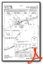
Instrument Approach Procedure (IAP) Charts
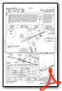
Nearby Airports with Instrument Procedures
| ID | Name | Heading / Distance | ||
|---|---|---|---|---|
 |
KCON | Concord Municipal Airport | 189° | 22.5 |
|
KDAW | Skyhaven Airport | 128° | 27.5 |
|
KIZG | White Mountain Regional Airport | 038° | 32.3 |
|
KSFM | Sanford Seacoast Regional Airport | 108° | 32.8 |
|
2B3 | Parlin Field Airport | 251° | 35.4 |
|
3B4 | Seacoast Airfield Airport | 132° | 38.2 |
|
KMHT | Manchester Boston Regional Airport | 181° | 38.4 |
|
KLEB | Lebanon Municipal Airport | 275° | 38.8 |
|
KPSM | Portsmouth International At Pease Airport | 138° | 39.5 |
|
5B9 | Dean Memorial Airport | 320° | 39.8 |
|
B19 | Biddeford Municipal Airport | 098° | 41.8 |
|
KCNH | Claremont Municipal Airport | 254° | 43.3 |


