Login
Register


CPT
Cleburne Regional Airport
Official FAA Data Effective 2026-01-22 0901Z
Chart Supplement

VFR Chart of KCPT
Sectional Charts at SkyVector.com
IFR Chart of KCPT
Enroute Charts at SkyVector.com
Location Information for KCPT
Coordinates: N32°21.22' / W97°26.03'Located 02 miles NW of Cleburne, Texas on 520 acres of land. View all Airports in Texas.
Surveyed Elevation is 854 feet MSL.
Operations Data
|
|
Airport Communications
| AWOS-3: | 119.525 Tel. 817-641-4135 |
|---|---|
| LONE STAR APPROACH: | 135.975 379.9 |
| LONE STAR DEPARTURE: | 135.975 379.9 |
| BOTCH DP: | 135.975 379.9 |
| WESAT STAR: | 118.1 ;SOUTH 125.8 ;NORTH 306.95 |
| TRUUK RNAV STAR: | 124.3 282.275 |
| SASIE STAR: | 124.3 282.275 |
| GARLAND DP: | 135.975 379.9 |
| DODJE STAR: | 125.2 125.9 343.65 |
| MOTZA STAR: | 118.1 ;SOUTH 125.8 ;NORTH 306.95 |
| CTAF: | 122.800 |
| LIKES STAR: | 125.8 ;SOUTH 135.975 ;NORTH 257.95 |
| JOE POOL DP: | 135.975 379.9 |
| REEKO STAR: | 125.2 343.65 |
| UNICOM: | 122.800 |
| ATIS at FWS (14.2 NE): | 120.025 |
| AWOS-3PT at FWS (14.2 NE): | 120.025 817-426-4172 |
| AWOS-3T at GDJ (20.2 W): | 118.925 817-573-7514 |
Nearby Navigation Aids
|
| ||||||||||||||||||||||||||||||||||||||||||||||||||||||||||||


Runway 15/33
| Dimensions: | 5697 x 100 feet / 1736 x 30 meters | |
|---|---|---|
| Surface: | Asphalt in Fair Condition | |
| Weight Limits: | S-30 | |
| Edge Lighting: | Medium Intensity | |
| Runway 15 | Runway 33 | |
| Coordinates: | N32°21.66' / W97°26.22' | N32°20.79' / W97°25.83' |
| Elevation: | 853.7 | 844.9 |
| Traffic Pattern: | Right | Left |
| Runway Heading: | 159° True | 339° True |
| Displaced Threshold: | 185 Feet | |
| Markings: | Non-Precision Instrument in good condition. | Non-Precision Instrument in good condition. |
| Glide Slope Indicator | P4L (3.00° Glide Path Angle) | |
| Obstacles: | 25 ft Trees 750 ft from runway, 60 ft right of center APCH SLOPE 37:1 TO DTHR. |
32 ft Pole 1340 ft from runway, 285 ft left of center |
Services Available
| Fuel: | 100LL (blue), Jet A+ |
|---|---|
| Transient Storage: | Hangars,Tiedowns |
| Airframe Repair: | MAJOR |
| Engine Repair: | MAJOR |
| Bottled Oxygen: | HIGH/LOW |
| Bulk Oxygen: | HIGH/LOW |
| Other Services: | AVIONICS,CHARTER SERVICE,PILOT INSTRUCTION,AIRCRAFT RENTAL |
Ownership Information
| Ownership: | Publicly owned | |
|---|---|---|
| Owner: | CITY OF CLEBURNE | |
| 10 N ROBINSON, PO BOX 677 | ||
| CLEBURNE, TX 76033 | ||
| 817-645-0900 | ||
| Manager: | CLINTON TUGGLE | |
| 1650 AIRPORT DRIVE | ||
| CLEBURNE, TX 76033 | ||
| 817-641-5456 | ||
Other Remarks
- THIS AIRPORT HAS BEEN SURVEYED BY THE NATIONAL GEODETIC SURVEY.
- FOR CD CTC REGIONAL APCH AT 972-615-2799.
- 0LL FUEL 24 HR SELF-SERVE. FOR ATTENDANT AFT HRS CALL 817-933-1650, CALL-IN FEE.
- ACTVT PAPI RWY 15; MIRL RWY 15/33 - CTAF.
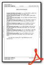
Weather Minimums

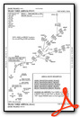
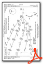
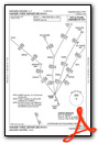
Standard Terminal Arrival (STAR) Charts
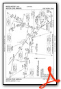
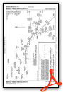
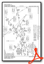

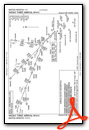
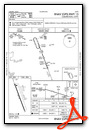
Instrument Approach Procedure (IAP) Charts

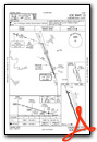
Departure Procedure (DP) Charts


Nearby Airports with Instrument Procedures
| ID | Name | Heading / Distance | ||
|---|---|---|---|---|
 |
KFWS | Fort Worth Spinks Airport | 026° | 14.2 |
|
50F | Bourland Field Airport | 329° | 15.8 |
|
KGDJ | Granbury Regional Airport | 285° | 20.4 |
|
KINJ | Hillsboro Municipal Airport | 133° | 23.6 |
|
KNFW | Fort Worth NAS Jrb (Carswell Field) Airport | 359° | 24.9 |
|
KGKY | Arlington Municipal Airport | 042° | 25.3 |
|
KWEA | Parker County Airport | 331° | 26.7 |
|
KJWY | Mid-Way Regional Airport | 076° | 27.2 |
|
KFTW | Fort Worth Meacham International Airport | 007° | 28.1 |
|
KGPM | Grand Prairie Municipal Airport | 043° | 28.5 |
|
KRBD | Dallas Exec Airport | 055° | 34.7 |
|
4T2 | Kenneth Copeland Airport | 355° | 37.5 |


