Login
Register


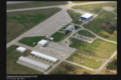
CYOO
Toronto/Oshawa Executive Airport Airport
VFR Chart of CYOO
Sectional Charts at SkyVector.com
IFR Chart of CYOO
Enroute Charts at SkyVector.com
Location Information for CYOO
Coordinates: N43°55.37' / W78°53.78'View all Airports in Ontario, Canada.
Elevation is 460 feet MSL.
Magnetic Variation from 2015 is 11° West
Time Zone is UTC-5(4).
Operations Data
|
|
Customs Information
AOE/50 1330-2130Z Mon-Fri
888-226-7277; AOE/15 Gen Avn
12-05Z
Airport Communications
| Remote Communications Outlet (RCO) | London Radio 123.15 (FISE) |
|---|---|
| Automated Terminal Information Service (ATIS) | 125.675 1130-0330Z |
| Ground Control (GND) | 118.4 1130-0330Z |
| Mandatory Frequency (MF) | traffic 120.1 0330-1130Z 5NM 3000 ASL (CAR 602.98) |
| Control Tower (TWR) | 120.1 (V) 1130-0330Z (Emergency only 905-576-2398) |
| Arrival (ARR) | Toronto tml 133.4 |
| Departure (DEP) | Toronto tml 133.4 |
| Automated Weather Observation System (AWOS) | 125.675 0330-1130Z |
Nearby Navigation Aids
|
| ||||||||||||||||||||||||||||||||||||||||||||||||||||||||||||


Runway 12/30
| Dimensions: | 4250 x 100 feet. | |
|---|---|---|
| Surface: | ||
| Remarks | ASPH Rwy 12 down 0.31% | |
| Runway 12 | Runway 30 | |
| Runway Heading: | 122° | 302° |
| Approach Lights | Runway ID Lights (Strobes) | Runway ID Lights (Strobes) |
| Glide Slope Indicator | PAPI for aircraft with eye-to-wheel height up to 25 feet. | PAPI for aircraft with eye-to-wheel height up to 25 feet. |
Runway 05/23
| Dimensions: | 2654 x 100 feet. | |
|---|---|---|
| Surface: | ||
| Remarks | ASPH Rwy 23 down 0.6% | |
| Runway 05 | Runway 23 | |
| Runway Heading: | 046° | 226° |
| Approach Lights | Runway ID Lights (Strobes) | |
| Glide Slope Indicator | PAPI for aircraft with eye-to-wheel height up to 10 feet. | PAPI for aircraft with eye-to-wheel height up to 10 feet. |
Runway Conditions Reporting Source
Twr 905-576-2398 RSC/CRFI avbl 1130-0330Z Operator 905-243-9376
RSC/CRFI avbl 0330-1130Z PLR/PCN.
Taxiway Information
Normal Rwy 30 deps are from Twy B. Acft requiring full length must notify gnd ctl on
initial contact.
Services Available
| Fuel Available | 100LL (cardlock on Apron I), JA-1 |
|---|---|
| Oil Available | All |
| Servicing Available | Storage, Minor Repairs, Major Repairs, Extended Parking, Tie Downs, Plug-in |
| Private Advisory | Enterprise Air Inc 131.05 905-721-0054 |
Public Facilities
| Location | Facilities | Remarks |
|---|---|---|
| In Terminal Building | Food | 7 |
| On Aerodrome | Car Rental | |
| Within 5 NM | Telephone, Taxi, Medical Aid, Accomodations |
Flight Planning
| Instructions | Pilots to open/close VFR flt pln with London rdo 123.15 or by phone. |
|---|---|
| Flight Information Centre (FIC) | London 866-WXBRIEF (Toll free within Canada) or 866-541-4104 (Toll free within Canada & USA) |
| Weather (WX) | METAR AUTO H24 (see COMM) TAF H24, issue times: 02, 08, 14 and 20Z WxCam |
Aerodrome Operator
Corporation of the City of Oshawa
905-576-8146 11-04Z O/T PN Cert
Nearby Airports with Instrument Procedures
| ID | Name | Heading / Distance | ||
|---|---|---|---|---|
 |
CYTZ | Toronto/Billy Bishop Toronto City Airport | 242° | 28.0 |
|
CYPQ | Peterborough Airport | 062° | 29.5 |
|
CYYZ | Toronto/Lester B. Pearson International Airport | 256° | 35.2 |
|
CYLS | Barrie-Orillia/Lake Simcoe Airport | 331° | 44.2 |
|
CYSN | St Catharines/Niagara District Airport | 206° | 45.5 |
|
CNV8 | Edenvale Airport | 315° | 55.6 |
|
CYTR | Trenton Airport | 089° | 60.4 |
|
CNY3 | Collingwood Airport | 311° | 63.0 |
|
CYHM | Hamilton Airport | 236° | 63.8 |
|
CYQA | Muskoka Airport | 355° | 65.5 |
|
CYKF | Kitchener/Waterloo Airport | 258° | 70.2 |
|
CYFD | Brantford Airport | 244° | 78.9 |