Login
Register


DE00
Doyle's Airport
Official FAA Data Effective 2026-01-22 0901Z
VFR Chart of DE00
Sectional Charts at SkyVector.com
IFR Chart of DE00
Enroute Charts at SkyVector.com
Location Information for DE00
Coordinates: N39°1.24' / W75°34.63'Located 02 miles SSW of Felton, Delaware on 36 acres of land. View all Airports in Delaware.
Estimated Elevation is 51 feet MSL.
Operations Data
|
|
Airport Communications
| D-ATIS at DOV (8.3 NE): | 127.825 |
|---|---|
| AWOS-3 at 33N (11.9 N): | 120.125 302-571-6012 |
| ASOS at GED (22.3 SE): | 118.375 302-855-1052 |
Nearby Navigation Aids
|
| ||||||||||||||||||||||||||||||||||||||||||||||||||||||||||||


Runway 16/34
| Dimensions: | 2000 x 50 feet / 610 x 15 meters | |
|---|---|---|
| Surface: | Turf | |
| Runway 16 | Runway 34 | |
| Displaced Threshold: | 500 Feet | |
| Obstacles: | 25 ft Power Line 100 ft from runway | |
Ownership Information
| Ownership: | Privately Owned | |
|---|---|---|
| Owner: | DAVID & CATHERINE DOYLE | |
| 1029 PEACH BASKET RD | ||
| FELTON, DE 19943 | ||
| 302-284-2101 | ||
| Manager: | DAVID & CATHERINE DOYLE | |
| 1029 PEACH BASKET RD | ||
| FELTON, DE 19943 | ||
| 302-284-2101 | ||
Other Remarks
- FOR CD CTC WASHINGTON ARTCC AT 703-771-3587.
Nearby Airports with Instrument Procedures
| ID | Name | Heading / Distance | ||
|---|---|---|---|---|
 |
KDOV | Dover AFB Airport | 038° | 8.3 |
|
33N | Delaware Airpark Airport | 354° | 11.9 |
|
KRJD | Gooden Airpark Airport | 257° | 13.9 |
|
KGED | Delaware Coastal Airport | 152° | 22.4 |
|
KESN | Easton/Newnam Field Airport | 240° | 26.4 |
|
N06 | Laurel Airport | 181° | 28.7 |
|
KEVY | Summit Airport | 347° | 30.8 |
|
KWWD | Cape May County Airport | 091° | 31.3 |
|
KMIV | Millville Municipal Airport | 048° | 31.4 |
|
W29 | Bay Bridge Airport | 265° | 35.3 |
|
KCGE | Cambridge-Dorchester Regional Airport | 216° | 35.8 |
|
58M | Claremont Airport | 337° | 35.9 |
Airport Images
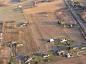
By: jlshoem

By: jlshoem


