Login
Register


DE17
Sugar Hill Airport
Official FAA Data Effective 2024-07-11 0901Z
VFR Chart of DE17
Sectional Charts at SkyVector.com
IFR Chart of DE17
Enroute Charts at SkyVector.com
Location Information for DE17
Coordinates: N38°46.67' / W75°35.00'Located 02 miles SE of Greenwood, Delaware on 238 acres of land. View all Airports in Delaware.
Estimated Elevation is 45 feet MSL.
Operations Data
|
|
Airport Communications
| ASOS at GED (11.6 SE): | 118.375 302-855-1052 |
|---|---|
| D-ATIS at DOV (21.8 N): | 127.825 |
| ATIS at ESN (22.8 W): | 124.475 |
Nearby Navigation Aids
|
| ||||||||||||||||||||||||||||||||||||||||||||||||||||||||||||


Runway 03/21
| Dimensions: | 2300 x 100 feet / 701 x 30 meters | |
|---|---|---|
| Surface: | Turf | |
| Edge Lighting: | Low Intensity | |
| Runway 03 | Runway 21 | |
Ownership Information
| Ownership: | Privately Owned | |
|---|---|---|
| Owner: | ROBERT HUNSBERGER | |
| 14478 SUGAR HILL RD | ||
| GREENWOOD, DE 19950 | ||
| 302-542-8161 | ||
| Manager: | ROBERT HUNSBERGER | |
| 14478 SUGAR HILL RD | ||
| GREENWOOD, DE 19950 | ||
| 302-542-8161 | ||
Other Remarks
- FOR CD CTC WASHINGTON ARTCC AT 703-771-3587.
- FOR RWY LGTS CALL 302-542-8161.
Nearby Airports with Instrument Procedures
| ID | Name | Heading / Distance | ||
|---|---|---|---|---|
 |
KGED | Delaware Coastal Airport | 117° | 11.8 |
|
N06 | Laurel Airport | 182° | 14.1 |
|
KRJD | Gooden Airpark Airport | 311° | 17.6 |
|
KDOV | Dover AFB Airport | 014° | 21.8 |
|
KESN | Easton/Newnam Field Airport | 274° | 22.8 |
|
KCGE | Cambridge-Dorchester Regional Airport | 235° | 25.4 |
|
33N | Delaware Airpark Airport | 358° | 26.4 |
|
KSBY | Salisbury-Ocean City Wicomico Regional Airport | 172° | 26.5 |
|
KWWD | Cape May County Airport | 066° | 34.5 |
|
KOXB | Ocean City Municipal Airport | 142° | 35.4 |
|
W29 | Bay Bridge Airport | 289° | 37.0 |
|
KMIV | Millville Municipal Airport | 033° | 42.7 |
Airport Images
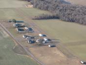
By: jlshoem
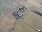
By: jlshoem


