Login
Register


DKK
Chautauqua County/Dunkirk Airport
Official FAA Data Effective 2026-01-22 0901Z
Chart Supplement

KDKK Airport Diagram

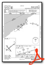
VFR Chart of KDKK
Sectional Charts at SkyVector.com
IFR Chart of KDKK
Enroute Charts at SkyVector.com
Location Information for KDKK
Coordinates: N42°29.64' / W79°16.27'Located 03 miles E of Dunkirk, New York on 450 acres of land. View all Airports in New York.
Surveyed Elevation is 692 feet MSL.
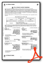
Operations Data
|
|
Airport Communications
| ASOS: | 119.275 Tel. 716-366-7664 |
|---|---|
| BUFFALO APPROACH: | 126.5 317.6 |
| BUFFALO DEPARTURE: | 126.5 317.6 |
| CTAF: | 123.075 |
| UNICOM: | 123.075 |
| AWOS-3PT at JHW (20.5 S): | 118.425 716-664-6005 |
| AWOS-3P at XNT (27.1 E): | 122.8 716-592-4400 |
| ASOS at BUF (35.7 NE): | 716-587-0517 |
Nearby Navigation Aids
|
| ||||||||||||||||||||||||||||||||||||||||||||||||||||||


Runway 06/24
| Dimensions: | 6000 x 100 feet / 1829 x 30 meters | |
|---|---|---|
| Surface: | Asphalt / Grooved in Fair Condition | |
| Weight Limits: | S-49, D-68, ST-130 | |
| Edge Lighting: | High Intensity | |
| Runway 06 | Runway 24 | |
| Coordinates: | N42°29.36' / W79°16.69' | N42°30.01' / W79°15.68' |
| Elevation: | 673.9 | 661.5 |
| Traffic Pattern: | Left | Left |
| Runway Heading: | 49° True | 229° True |
| Markings: | Non-Precision Instrument in fair condition. | Non-Precision Instrument in fair condition. |
| Glide Slope Indicator | P4L (3.00° Glide Path Angle) | P4L (3.00° Glide Path Angle) |
| REIL: | Yes | Yes |
| Obstacles: | 30 ft Tree 405 ft from runway, 44 ft right of center | |
Runway 15/33
| Dimensions: | 4000 x 100 feet / 1219 x 30 meters | |
|---|---|---|
| Surface: | Asphalt in Fair Condition | |
| Weight Limits: | S-49, D-68, ST-130 | |
| Edge Lighting: | Medium Intensity | |
| Runway 15 | Runway 33 | |
| Coordinates: | N42°29.81' / W79°16.68' | N42°29.31' / W79°16.10' |
| Elevation: | 660.4 | 692.3 |
| Traffic Pattern: | Left | Left |
| Runway Heading: | 139° True | 319° True |
| Markings: | Non-Precision Instrument in fair condition. | Non-Precision Instrument in fair condition. |
| Glide Slope Indicator | P4L (3.00° Glide Path Angle) | P4L (3.10° Glide Path Angle) |
| Obstacles: | 70 ft Tree 787 ft from runway, 300 ft right of center | 62 ft Trees 775 ft from runway, 273 ft right of center |
Services Available
| Fuel: | 100LL (blue), Jet-A, Jet A+ |
|---|---|
| Transient Storage: | Hangars,Tiedowns |
| Airframe Repair: | MINOR |
| Engine Repair: | MAJOR |
| Bottled Oxygen: | NONE |
| Bulk Oxygen: | HIGH/LOW |
Ownership Information
| Ownership: | Publicly owned | |
|---|---|---|
| Owner: | CHAUT CO | |
| N. ERIE STREET | ||
| MAYVILLE, NY 14701 | ||
| 716-753-8406 | ||
| Manager: | JOHN MACHEMER | |
| 3163 AIRPORT DR | ||
| JAMESTOWN, NY 14701 | ||
| 716-581-0062 | ||
Other Remarks
- DEER & BIRDS INVOF AIRPORT
- FICONS NOT RGLRLY MNT.
- COLD TEMPERATURE AIRPORT. ALTITUDE CORRECTION REQUIRED AT OR BELOW -21C.
- FOR CD CTC BUFFALO ATCT AT 716-626-6939/6919.
- ACTVT HIRL RWY 06/24, MIRL RWY 15/33, PAPI 06, 24, 15, & 33, & REIL RWY 6 & 24 -CTAF.
Weather Minimums
Instrument Approach Procedure (IAP) Charts
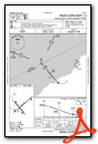
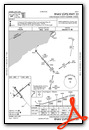

Nearby Airports with Instrument Procedures
| ID | Name | Heading / Distance | ||
|---|---|---|---|---|
 |
KJHW | Chautauqua County/Jamestown Airport | 178° | 20.4 |
|
9G0 | Buffalo Airfield Airport | 047° | 33.0 |
|
KBUF | Buffalo Niagara International Airport | 041° | 35.9 |
|
KBQR | Buffalo-Lancaster Regional Airport | 048° | 38.9 |
|
8G2 | Corry-Lawrence Airport | 205° | 38.8 |
|
KIAG | Niagara Falls International Airport | 021° | 39.6 |
|
CYSN | St Catharines/Niagara District Airport | 005° | 42.1 |
|
KOLE | Cattaraugus County-Olean Airport | 110° | 42.8 |
|
9G3 | Akron/Jesson Field Airport | 047° | 47.1 |
|
KERI | Erie International/Tom Ridge Field Airport | 238° | 47.2 |
|
KBFD | Bradford Regional Airport | 145° | 50.1 |
|
6G1 | Titusville Airport | 201° | 57.1 |
Airport Images
Do you have a recent image of this airport? Upload it here!


